Khao Phing Kan facts for kids
|
Native name:
เขาพิงกัน
|
|
|---|---|
 |
|
| Geography | |
| Location | Southeast Asia |
| Coordinates | 8°16′29″N 98°30′04″E / 8.274591°N 98.501151°E |
| Administration | |
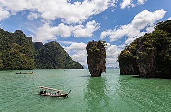
Khao Phing Kan (which means 'hills leaning against each other' in Thai) is a famous island in Thailand. It's located in Phang Nga Bay, northeast of Phuket. These islands are special because they are made of tall, pointy limestone rocks called karst towers. They are part of the beautiful Ao Phang Nga National Park.
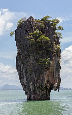
Close to Khao Phing Kan, about 40 meters (130 feet) away, there's a smaller, 20-meter (66-foot) tall rock called Ko Ta Pu or Ko Tapu. Since 1974, after they appeared in the James Bond movie The Man with the Golden Gun, both Khao Phing Kan and Ko Ta Pu became known as James Bond Island.
Contents
What's in a Name?
The name Khao Phing Kan means 'hills leaning against each other' in Thai. This describes how the two main islands look connected.
Khao Ta Pu can mean 'crab's eye' island, and Ko Tapu means 'nail' or 'spike' island. These names describe its unique shape. The words koh (meaning 'island') and khao (meaning 'hill') are often used interchangeably when naming these islands.
After the 1974 James Bond movie The Man with the Golden Gun, tourists started calling them James Bond Island. This name is now much more common than their original Thai names.
A Famous Island's Story
Before 1974, Khao Phing Kan was a quiet place that few people visited. But then, it was chosen as a filming location for the James Bond movie The Man with the Golden Gun. In the movie, it was the secret hideout for the villain, Francisco Scaramanga.
After the movie came out, the island became a very popular spot for tourists. This popularity also led to a lot of litter on the island.
In 1981, the island became the most famous part of the new Ao Phang Nga Marine National Park. To protect the unique limestone rocks, tourist boats have not been allowed to get too close to Ko Ta Pu since 1998. This rule helps prevent the rocks from eroding and possibly collapsing.
Exploring the Islands
Khao Phing Kan: The Leaning Hills
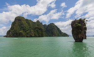
Khao Phing Kan is made up of two islands covered in forests with steep sides. They are located in the northwestern part of Phang Nga Bay, about 6 kilometers (3.7 miles) from the mainland. Many other islands are nearby.
The western part of the island is about 130 meters (427 feet) wide. The eastern part is longer, about 240 meters (787 feet) long and 140 meters (459 feet) wide.
The island has a few caves and two sandy beaches. One beach is in the southwest, and the other is between the two main islands. The beach between the islands is where tourist boats arrive. It also has souvenir shops selling items like shells and local crafts.
The beaches and caves often get covered by water when the tides come in. The water level can change by 2 to 3 meters (6.6 to 9.8 feet). So, you can only visit some caves when the tide is low. The Thai name for Khao Phing Kan describes how the island looks like a flat limestone cliff leaning against another rock.
The water around the island is shallow and has a pale-green color. The bottom is covered with silt, which is fine dirt brought into Phang Nga Bay by rivers.
Ko Ta Pu: The Nail Island
Ko Ta Pu is a limestone rock that stands about 20 meters (66 feet) tall. It's wider at the top (about 8 meters or 26 feet across) and narrower near the water (about 4 meters or 13 feet across). It sits about 40 meters (130 feet) west of Khao Phing Kan.
How Ko Ta Pu Was Formed
There's a local legend about how Ko Ta Pu was formed. A long time ago, a fisherman always caught many fish. But one day, he only caught a nail in his net. No matter how many times he threw the nail back, he kept catching it. In anger, he cut the nail in half with his sword. One half of the nail flew up and landed in the sea, forming Ko Ta Pu.
Scientists have a different explanation. Millions of years ago, this area was a coral reef. Over time, the Earth's plates moved, breaking the reef apart. The ocean levels rose, covering these pieces. Wind, waves, and tides slowly shaped these islands, creating unique forms like Ko Ta Pu. You can see how the tides have worn away the bottom of the rock.
In the James Bond movie The Man with the Golden Gun, the villain Scaramanga calls Ko Ta Pu a "mushroom-shaped rock." He says it hides two large solar panels that come out of the top to capture sunlight.
Ko Ta Pu has also appeared in other movies, including another James Bond film called Tomorrow Never Dies and the Italian movie Quo Vado?.
Island Weather
The area has a tropical monsoon climate. This means it often rains, and the temperature stays pretty stable. Between May and October, there are many rainy days, with a lot of rain falling each year. The temperature usually stays between 23°C (73°F) and 32°C (90°F). The air is also quite humid, around 83%.
Plants and Animals
Most of the island is covered with deciduous shrubs and evergreen trees. Some tough plants, like Pandanus, cycads, and euphorbs, can grow on the cliffs of Ko Ta Pu. They push their roots into tiny cracks and survive on rainwater.
The shallow, warm waters around the island are full of life. Many nutrients come from nearby mangrove forests and rivers. This creates a rich environment for tiny plankton and other marine creatures.
The bay is home to many different animals:
- Reptiles: 26 different kinds.
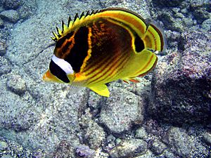
- Fish: 24 species, including colorful butterflyfish that live near coral reefs.
- Crabs and Shrimp: 15 types of crabs and 14 types of shrimp, like blue crabs and humpback shrimp.
- Other Sea Creatures: You can find manta rays, sharks, moray eels, puffer fish, sea cucumbers, and different kinds of brain coral and staghorn coral.
- Amphibians: Such as the Fejervarya raja and the common tree frog.
- Birds: Over 100 species, including the striated heron and little egret.
The water also has many aquatic plants like red algae, Halimeda, and seagrass.
 | Selma Burke |
 | Pauline Powell Burns |
 | Frederick J. Brown |
 | Robert Blackburn |


