King's Sedgemoor Drain facts for kids
Quick facts for kids King's Sedgemoor Drain |
|
|---|---|

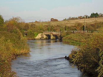
King's Sedgemoor Drain near Dunball
|
|
| Country | England |
| State | Somerset |
| Region | Somerset Levels |
| Physical characteristics | |
| Main source | River Cary Henley Corner, Somerset, England 51°05′26″N 2°48′28″W / 51.09056°N 2.80778°W |
| River mouth | River Parrett Dunball, Somerset, England 51°09′42″N 2°59′19″W / 51.16167°N 2.98861°W |
The King's Sedgemoor Drain is a special man-made channel in Somerset, England. It was built to help drain the wet, marshy lands of King's Sedgemoor. This channel takes water from the River Cary and guides it along the south side of the Polden Hills. Eventually, the water flows into the River Parrett near Dunball, which is close to Bridgwater.
People living in the area first worried about these drainage plans. They feared losing their rights to use the land for grazing animals. But the main channel was built between 1791 and 1795. It helped a lot with flooding, even though it had some small problems.
The drain was improved during the Second World War. It became a backup water supply for a factory making weapons. It was upgraded again in 1972 when the Sowy River flood relief channel was built. Today, the drain is a great place for fishing and is also important for many different kinds of birds.
Contents
Why the Drain Was Needed
The land where the King's Sedgemoor Drain now flows used to be common land. This meant everyone could use it for farming. After 1539, the land was divided, and the Crown owned the soil. In the 1600s, a man named Cornelius Vermuyden tried to build small drainage systems.
Even after a huge flood in 1607, people in Sedgemoor were not convinced. They worried that better pastures would mean they would lose their common rights. The land was often flooded, and the water just stayed there until it dried up.
Many plans for drainage were suggested in the late 1700s. But these plans often failed because landowners and commoners disagreed. Some plans were even scams to make money. However, new laws were passed between 1777 and 1801. These laws finally allowed drainage projects to begin in the Somerset moors.
Building the Big Drain

A law in 1791 allowed improvements to drain King's Sedgemoor. The old ways for water to flow out were not good enough. New plans suggested a channel from the area to an existing sluice called Dunball Clyse. A surveyor named William White found a good path for the drain.
The plan involved digging a deep channel about 2.5 miles (4 km) long through a slightly higher ridge of clay. This was needed to make sure the water could flow downhill. An engineer named William Jessop agreed with White's plan, so this route was chosen.
The King's Sedgemoor Drain is about 10.5 miles (17 km) long. It was finished in 1795. It starts at the River Cary at Henley Corner and goes to Dunball. The engineer for this project was Robert Anstice.
There were problems with the new sluice at Dunball. It was built on soft ground that used to be a bend in the river. This made the sluice about 4 feet (1.2 m) too high. This caused mud and dirt to build up in the channel. Also, the earth banks built from the dug-out soil made the peat underneath rise up in the middle of the drain. This problem was finally fixed by moving the banks further back.
The project also included new bridges. Some bridges had special gates to control water for irrigation. But many bridge openings were too small. This caused water to build up during floods. The whole project cost over £32,000 and helped drain about 11,000 acres (4,500 ha) of land.
Keeping the Drain Working
For the next 140 years, keeping the drain in good shape was a challenge. The people in charge, called the Commissioners of Sewers, did not do regular maintenance. The banks kept slipping, and the peat kept rising from the bottom of the drain.
Reports were made about the drain's poor condition, but nothing much happened. In 1828, local landowners took action themselves. They asked Josiah Easton to check the drain. He reported that the drain was almost useless and needed £10,000 to fix it.
In 1844, the sluice doors at Dunball were about to fall apart. They were lowered and new doors were fitted. But the moors still flooded almost every winter. New groups were put in charge, but they also struggled to raise enough money for repairs. In 1876, a high tide washed away the sluice gates. This caused the moors to flood again.
The Drain in Modern Times
A new law in 1930 brought hope for the future. Many small groups responsible for flood defenses were replaced by the Somerset Catchment Board. This new board could raise money more easily for drainage work.
In 1939, a new engineer took charge, and work began to improve the King's Sedgemoor Drain. The channel, bridges, and Dunball sluice were all too small. The start of the Second World War threatened to stop the work, but it continued.
During the war, a factory making explosives was built at Puriton. The Catchment Board needed to make sure the factory had enough water every day. The Huntspill River was built for this purpose. The King's Sedgemoor Drain was made a backup water source. All the planned improvements were finished to ensure water was always available. Greylake sluice was built in 1942 to control water levels.
The drain was upgraded again in 1972. This was part of a big project to build a flood relief channel for the River Parrett, called the Sowy River. Improvements to the drain included moving and rebuilding the sluice at Dunball. This new sluice keeps salt water from entering the drain where it meets the River Parrett.
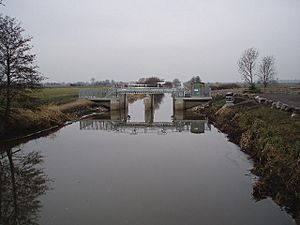
In 2006, Greylake Sluice was improved again. This £2.95 million project won an award for its safety and environmental care. The new design has two tilting gates that allow for better control of water levels.
Most of the Somerset Levels are drained by pumping stations. But the King's Sedgemoor Drain works only by gravity. This means water flows out naturally without pumps. The Environment Agency manages the main drain. Smaller drainage ditches that feed into the drain are managed by local drainage boards.
Wildlife Along the Drain
In 2008, a special "eel-pass" was added at Greylake Sluice. This is an open metal channel with bristles on the bottom. It helps young eels, called glass eels, wiggle their way past the sluice. These eels travel all the way from the Sargasso Sea. An infra-red camera watches the eels at night. This has given important information about how eels move and why their numbers are going down.
The King's Sedgemoor Drain has many fish. It was even used for the National Fishing Championships in 2008.
Near Greylake, the Royal Society for the Protection of Birds has a reserve. It covers about 270 acres (110 ha). You can see birds like Eurasian curlews, lapwings, and snipe in summer. In winter, birds like Bewick's swans and golden plovers arrive.
How Clean is the Water?
The Environment Agency checks the water quality of rivers in England. They give each river an overall ecological status. This can be high, good, moderate, poor, or bad. This status looks at things like the types of invertebrates, plants, and fish living in the water. They also check for chemicals. Chemical status is either good or fail.
In 2015, the water quality of the King's Sedgemoor Drain was rated as "moderate" for its overall ecological status. Its chemical status was "good." This data includes the Sowy River.
Following the Drain's Path
In ancient Roman times, the River Parrett flowed differently. It followed part of the path that the King's Sedgemoor Drain uses today. It made a big loop along the south side of the Polden Hills.
The King's Sedgemoor Drain begins at a narrow sluice at Henley Corner. This sluice sends most of the water from the River Cary into the drain. The drain then flows north-west. It passes under Cradle Bridge and then Greylake Bridge, which carries the A361 road.
Near Greylake Bridge, the Sowy River joins the drain. Just north of the bridge is the RSPB bird reserve. To the south, there is a special area of land called Burtle Beds, which is protected for its unique geology.
The drain then passes near Westonzoyland village, where the Battle of Sedgemoor was fought in 1685. It turns north, passing under roads at Parchey and Bawdrip. At Crandon Bridge, the A39 road crosses the drain.
Finally, the drain passes south of Puriton. It goes under the M5 motorway, a railway line, and the A38 road. It then reaches the River Parrett at Dunball clyse.
| Point | Coordinates (Links to map resources) |
OS Grid Ref | Notes |
|---|---|---|---|
| Dunball Clyce | 51°09′40″N 2°59′17″W / 51.161°N 2.988°W | ST309407 | Junction with River Parrett |
| Sowy River Junction | 51°06′43″N 2°53′17″W / 51.112°N 2.888°W | ST379351 | River Parret flood channel |
| Greylake Sluice | 51°06′22″N 2°51′47″W / 51.106°N 2.863°W | ST396344 | |
| Henley Corner | 51°05′24″N 2°48′29″W / 51.090°N 2.808°W | ST435327 | Junction with River Cary |
 | John T. Biggers |
 | Thomas Blackshear |
 | Mark Bradford |
 | Beverly Buchanan |


