King City, Missouri facts for kids
Quick facts for kids
King City, Missouri
|
|
|---|---|

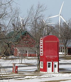
Big Pump and wind farm in the Tri-County Historical Park
|
|

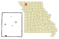
Location of King City, Missouri
|
|

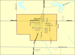
U.S. Census Map
|
|
| Country | United States |
| State | Missouri |
| County | Gentry |
| Area | |
| • Total | 1.38 sq mi (3.58 km2) |
| • Land | 1.38 sq mi (3.58 km2) |
| • Water | 0.00 sq mi (0.00 km2) |
| Elevation | 1,109 ft (338 m) |
| Population
(2020)
|
|
| • Total | 799 |
| • Density | 578.15/sq mi (223.25/km2) |
| Time zone | UTC-6 (Central (CST)) |
| • Summer (DST) | UTC-5 (CDT) |
| ZIP code |
64463
|
| Area code(s) | 660 |
| FIPS code | 29-38774 |
| GNIS feature ID | 2395536 |
King City is a small city located in the southwest part of Gentry County, Missouri, in the United States. In 2020, the city had a population of 799 people. It's a place with interesting history and a strong community spirit.
Contents
History of King City
Early Settlement and Naming
The first European settler in the area was John Pittsenbarger. He set up his tent in 1856. He wanted to name the town Petersburg, but that name was already taken by another town in Boone County, Missouri.
Local stories say that the United States Postmaster General suggested the name King City. The Postmaster General at that time was Horatio King.
Railroad and Bluegrass Farming
In 1878, King City became a stop on the St. Joseph and Des Moines Railway. This railway later became part of the Burlington Northern network. Today, this railway line is no longer used.
In the early 1900s, King City was a very important area for harvesting Kentucky bluegrass seeds. This region stretched from Kearney, Missouri to Maitland, Missouri. People even said it produced more bluegrass seeds than the entire state of Kentucky! A local resident, John Weller, was known as the "King of Blue Grass Raisers." However, by the 1950s, bluegrass seed production moved to other farming areas, like the Pacific Northwest.
The Big Pump and Wind Farm
In the 1990s, a unique building called the Big Pump was moved to King City. It looks like a giant gasoline pump and stands 25-foot (7.6 m) tall. The Big Pump is now on the National Register of Historic Places. It was built by Rufus Limpp, who was from King City. The Limpp Community Lake near King City is also named after him. The Big Pump is located at the Tri-County Museum.
In 2006, a company from St. Louis, Missouri started the Bluegrass Ridge Wind Farm. This farm has 27 large windmills about a mile north of King City. These windmills are 300 feet (91 m) high and were the first commercial electric windmills in Missouri. The wind farm's name honors the area's bluegrass history.
Local Businesses and Landmarks
King City has one main grocery store called McCrea's. It's a family business that has been open for over 50 years. Mr. McCrea, one of the original owners, still works there every day.
The Opera Hall Block is another important building in King City. It was added to the National Register of Historic Places in 2002.
Famous Former Resident
A well-known children's author, Clyde Robert Bulla, used to live in King City. He passed away in 2007.
Education in King City
King City has two schools, both called King City R-1. There is an elementary school and a junior high/high school. For many years, these schools were in separate buildings. After a fire, they were combined into one building while a new high school was built. Later, the two separate buildings were joined together with new classrooms and hallways. They have also added a new agriculture building and more classrooms.
Sports and Local Heroes
Roger Wehrli, a famous football player, went to King City High School. He played for the University of Missouri and then for the St. Louis (now Arizona) Cardinals in the NFL. He is even in the NFL Hall of Fame! King City's football field is named Wehrli Field in his honor. There are plans to upgrade the track at the field.
Geography of King City
King City is located right on US Route 169. It is about three-quarters of a mile north of the border between Gentry and Dekalb counties. Nearby towns include Stanberry, which is about eleven miles north, and Union Star, which is about six miles southwest.
The city covers a total area of 1.38 square miles (3.57 km2). All of this area is land, with no water.
Population Changes
| Historical population | |||
|---|---|---|---|
| Census | Pop. | %± | |
| 1880 | 196 | — | |
| 1890 | 622 | 217.3% | |
| 1900 | 905 | 45.5% | |
| 1910 | 966 | 6.7% | |
| 1920 | 1,150 | 19.0% | |
| 1930 | 1,101 | −4.3% | |
| 1940 | 1,103 | 0.2% | |
| 1950 | 1,031 | −6.5% | |
| 1960 | 1,009 | −2.1% | |
| 1970 | 1,023 | 1.4% | |
| 1980 | 1,063 | 3.9% | |
| 1990 | 986 | −7.2% | |
| 2000 | 1,012 | 2.6% | |
| 2010 | 1,013 | 0.1% | |
| 2020 | 799 | −21.1% | |
| U.S. Decennial Census | |||
The population of King City has changed over the years. In 1880, there were only 196 people. The population grew to over 1,000 people by the 1920s and stayed around that number for many decades. In 2020, the population was 799.
See also
 In Spanish: King City (Misuri) para niños
 | Sharif Bey |
 | Hale Woodruff |
 | Richmond Barthé |
 | Purvis Young |

