Kristianstad Municipality facts for kids
Quick facts for kids
Kristianstad Municipality
Kristianstads kommun
|
||
|---|---|---|

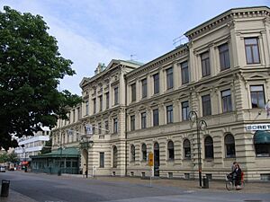
Kristianstad City Hall
|
||
|
||
 |
||
| Country | ||
| County | ||
| Seat | Kristianstad | |
| Area | ||
| • Total | 1,828.45 km2 (705.97 sq mi) | |
| • Land | 1,251.72 km2 (483.29 sq mi) | |
| • Water | 576.73 km2 (222.68 sq mi) | |
| Area as of January 1, 2010. | ||
| Population
(June 30, 2012)
|
||
| • Total | 79,207 | |
| • Density | 43.3192/km2 (112.1962/sq mi) | |
| Time zone | UTC+1 (CET) | |
| • Summer (DST) | UTC+2 (CEST) | |
| ISO 3166 code | SE | |
| Province | ||
| Municipal code | 1290 | |
| Website | www.kristianstad.se | |
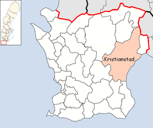
Kristianstad Municipality (which in Swedish is called Kristianstads kommun) is a special area in southern Sweden. It is part of Skåne County. The main town, or "seat," where the local government is located, is the city of Kristianstad.
This municipality was formed over several years. In 1967, many smaller country areas joined together to create the City of Kristianstad. More areas were added in 1971, and by 1974, the municipality became its current size. Originally, there were 35 separate local areas in 1863 that eventually became part of Kristianstad Municipality.
Contents
Geography
Kristianstad Municipality is the largest municipality in Skåne County by land area. It covers about 1,818 square kilometers (about 702 square miles).
Localities
There are 26 urban areas (called tätort in Swedish) within Kristianstad Municipality. These are towns or villages where people live closely together.
The table below lists these urban areas. They are ordered by how many people live in them, based on numbers from December 31, 2020. The main town, Kristianstad, is shown in bold.
| # | Urban area | Population |
|---|---|---|
| 1 | Kristianstad | 41,299 |
| 2 | Åhus | 10,487 |
| 3 | Hammar | 3,556 |
| 4 | Tollarp | 3,449 |
| 5 | Fjälkinge | 1,860 |
| 6 | Färlöv | 1,550 |
| 7 | Önnestad | 1,442 |
| 8 | Degeberga | 1,328 |
| 9 | Viby | 1,204 |
| 10 | Everöd | 925 |
| 11 | Gärds Köpinge | 920 |
| 12 | Arkelstorp | 791 |
| 13 | Rinkaby | 749 |
| 14 | Yngsjö | 717 |
| 15 | Balsby | 514 |
| 16 | Österslöv | 475 |
| 17 | Linderöd | 471 |
| 18 | Bäckaskog | 317 |
| 19 | Nyehusen och Furuboda | 310 |
| 20 | Huaröd | 267 |
| 21 | Östra Sönnarslöv | 265 |
| 22 | Vånga | 259 |
| 23 | Bjärlöv | 242 |
| 24 | Vittskövle | 239 |
| 25 | Vanneberga | 218 |
| 26 | Skepparslöv | 201 |
Demographics
Demographics is the study of people in a certain area, looking at things like age, where they were born, and how many people live there. In 2022, during the Swedish general election, there were 86,502 people living in Kristianstad Municipality. Out of these, 65,373 were Swedish citizens old enough to vote.
When people voted, 37.5% chose parties from the "left coalition" (groups of political parties with similar ideas, often focused on social equality). Meanwhile, 61.0% voted for parties from the "right coalition" (another group of parties, often focused on individual freedom and lower taxes).
Kristianstad was the most populated municipality in Sweden where the Sweden Democrats party received the most votes. The right coalition had a lead of 12,610 votes over the left coalition in this municipality.
International Relations
Kristianstad Municipality has special partnerships with other towns and cities around the world. These are called "twin towns" or "sister cities." This means they work together on cultural, educational, and economic projects.
Twin Towns — Sister Cities
Kristianstad Municipality is twinned with these places:
 Espoo, Finland
 Kongsberg, Norway
 Koszalin, Poland
 Køge Municipality, Denmark
 Rendsburg, Germany
 Šiauliai, Lithuania
 Skagafjörður, Iceland
See also
 In Spanish: Municipio de Kristianstad para niños
 | Laphonza Butler |
 | Daisy Bates |
 | Elizabeth Piper Ensley |


