La Conchita, California facts for kids
Quick facts for kids
La Conchita, California
|
|
|---|---|
| Country | United States |
| State | California |
| County | Ventura |
| Population
(2000)
|
|
| • Total | 338 |
| Time zone | UTC-8 (Pacific (PST)) |
| • Summer (DST) | UTC-7 (PDT) |
| ZIP codes |
93001
|
| Area code(s) | 805 |
| GNIS feature ID | 1661263 |
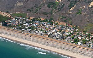
La Conchita (![]() i/ˌlɑː kənˈtʃiːtə/; Spanish for "The Little Shell") is a small community in Ventura County, California. It's located right on U.S. Route 101, near the border of Santa Barbara County.
i/ˌlɑː kənˈtʃiːtə/; Spanish for "The Little Shell") is a small community in Ventura County, California. It's located right on U.S. Route 101, near the border of Santa Barbara County.
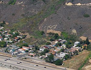
La Conchita is known for its beautiful coastal views. However, it has also faced challenges. On January 10, 2005, a big landslide happened here. This landslide sadly killed 10 people and damaged many homes. It happened in an area where a smaller landslide had occurred in 1995.
Contents
History of La Conchita
The name "La Conchita" means "little conch shell" in Spanish. It was first used for a railroad stop in the 1880s. Back then, the small beach town was called "Punta." Its streets were named after places where railroad workers came from, like San Fernando and Bakersfield.
The name "La Conchita" later became official for the village we know today. Before that, the coastal area was called Punta Gorda, meaning "massive point." This name referred to a large rock sticking out into the sea.
Early Days and Settlers (1817–1912)
The land where La Conchita now sits was once part of a large Mexican ranch. In the 1860s, after a long dry period, the land was divided and sold. Many new people came to California because of the Homestead Acts.
One early settler, Levi Gould Stanchfield, started a ranch here in 1875. He raised sheep and grew lima beans. Later, Charles E. Ablett, a druggist from Santa Barbara, bought the property. He was important in the early development of the area.
Around this time, the Southern Pacific railroad line was being built. The village of Punta grew as a result. Families like the Callis, Mullins, and Gaynors were among the first to settle here.
From 1880 to 1916, Punta had its own U.S. post office. It was also a stop for stagecoaches and trains. The first school in the area, the Rincon School, opened in 1883. It later became the Punta Gorda School District.
Building the railroad tracks along the coast was tough. There wasn't much room for a road. So, in 1910, they built a wooden causeway, like a bridge, around the cliffs. This became part of the Rincon Sea Level Road. By 1912, it was part of California's state highway system. It was later replaced with a concrete road in 1926.
Farming was the main job for many years. But it was hard because there wasn't much fresh water. People drilled for water, and oil drilling also became important. The Rincon Oil Field, near the town, was found in 1927.
Growing as a Community (1913–1959)
In the 1920s, a map of La Conchita was first made. At that time, it was mostly home to workers from nearby oil fields.
In 1923, Edward C. Ramelli bought land with a resort hotel called the Mussel Rock Inn. His brother, Milton, was a surveyor. He planned the first 19 homes and called the area "La Conchita del Mar." They promoted it as an affordable beach paradise. Lots started at $200 and even included oil rights! It was called a "beach with a future."
Even though oil was found nearby, no oil was discovered in La Conchita itself. Also, the promise of fresh water for all the lots didn't come true for a long time.
For many years, La Conchita stayed a small, quiet place. People built summer homes on the beach, enjoying the peace and beauty.
In 1928, Eleanor Gallardo Ramey was born in La Conchita. Her father, Joseph Gallardo, built their home. The Gallardo house still stands today. Joseph worked for the railroad. Eleanor remembers going to the one-room Punta Gorda Schoolhouse in La Conchita.
Pete Richardson came to La Conchita in 1928 when he was two. His father worked in the oil fields. Dick Talaugon's family moved there in 1932. They were part of a growing community of Pacific Islanders who worked on local farms.
By 1930, about a dozen families lived in small cottages. Lima beans grew around the community. Water was delivered by a company for 25 cents per five-gallon jug. A reliable water source finally arrived in 1959 with the building of Casitas Dam.
A popular restaurant called Frank and Rudy's was once located on the beach. It even had a glass dance floor over the water! Famous Hollywood people like Marie Dressler visited it. It closed in 1942.
In the 1950s, the highway was made wider. Many beach cottages had to be moved or taken down. La Conchita then became a popular vacation spot for families from the San Fernando Valley. Mobile homes and beach cottages appeared, and later, larger custom homes.
Recent Times and Landslides (1960–Present)
In 1975, the La Conchita Ranch Co. started farming the flat area above the community. They grew citrus fruits and avocados.
The Seaside Banana Gardens, a unique attraction, opened in La Conchita in 1985. It grew over 50 types of exotic bananas! It was very famous and featured in magazines. Sadly, it closed in 1998 after a mudslide affected the area.
Famous artist Roger Brown lived in La Conchita from the late 1980s until his death in 1997. The town and its environment inspired many of his paintings. His pink adobe studio home, designed by architect Stanley Tigerman, is a landmark in La Conchita.
In 1995, the first major mudslide hit the village. Then, on January 10, 2005, a much larger landslide occurred. This event tragically took the lives of ten residents.
After the 2005 landslide, residents formed the La Conchita Community Organization (LCCO). They worked with government officials to find solutions for the landslide problem. In 2006, the Governor announced money for a study to make the community safer.
In 2008, families affected by the 2005 landslide settled a lawsuit against the La Conchita Ranch. The ranch was found partly responsible. However, a lawsuit against Ventura County was not successful. The court decided that the warnings given by the County about the dangers of living in La Conchita were clear enough.
As of 2015, La Conchita is still an active community with about 300 residents. People are aware of the risk of more landslides. Ideas like reshaping the hill or the government buying the town have been discussed, but no big changes have happened yet.
Geography
La Conchita is a small town with two main streets running along the coast. Ten shorter streets connect these to the base of Rincon Mountain.
The town is located between Rincon Point to the northwest and Mussel Shoals to the southeast. The tall Rincon Mountain rises sharply to the northeast. The closest city is Carpinteria, about five miles (8 km) away.
 | Frances Mary Albrier |
 | Whitney Young |
 | Muhammad Ali |


