
La Moille, Illinois facts for kids
Quick facts for kids
La Moille, Illinois
|
|
|---|---|

Historic school in La Moille
|
|

Location of La Moille in Bureau County, Illinois.
|
|
.svg)
Location of Illinois in the United States
|
|
| Country | United States |
| State | Illinois |
| County | Bureau |
| Townships | Lamoille, Clarion |
| Area | |
| • Total | 1.16 sq mi (3.0 km2) |
| • Land | 1.16 sq mi (3.0 km2) |
| • Water | 0.00 sq mi (0 km2) 0% |
| Population
(2020)
|
|
| • Total | 679 |
| • Density | 585.3/sq mi (226.0/km2) |
| Time zone | UTC-6 (CST) |
| • Summer (DST) | UTC-5 (CDT) |
| ZIP Code(s) |
61330
|
| Area code(s) | 815 |
| FIPS code | 17-41794 |
La Moille is a small village located in Bureau County, Illinois, in the United States. In 2020, about 679 people lived there. It is part of the larger Ottawa area. The village got its name from the Lamoille River valley, which is in Vermont.
Contents
History of La Moille Village

La Moille was first settled in 1830 by Daniel Dimmick. He later founded another town called Dimmick, Illinois after the Blackhawk War. The village was first called Greenfield when it was planned, but its name was soon changed to La Moille.
In 1870, a new train line, the Chicago, Burlington, and Quincy Railroad, started running through La Moille. This brought both people and goods between Mendota, IL and Fulton, IL.
By 1877, La Moille had grown quite a bit. It had a hotel, several churches, and more than a dozen stores. There was also a grain elevator and doctors. The town even had a one room schoolhouse. These businesses formed a downtown area that stretched for three blocks.
The Allen School was built in 1887. This helped with the growing number of students and the combining of public schools. Sadly, a big fire on May 19, 1916, destroyed much of the northern part of the downtown area.
Geography of La Moille
La Moille is located at 41°31′45″N 89°16′52″W / 41.52917°N 89.28111°W. This means it is in a specific spot on the map.
The village covers an area of about 1.16 square miles (3.00 square kilometers). All of this area is land, with no large bodies of water inside the village limits.
La Moille is an important meeting point for several roads. It is where State Highway 92 and U.S. Route 34 cross. Also, State Highway 89 and U.S. Route 34 meet here.
Pike Creek, a small stream that flows into Big Bureau Creek, runs south through the town.
Population and People
| Historical population | |||
|---|---|---|---|
| Census | Pop. | %± | |
| 1880 | 488 | — | |
| 1890 | 516 | 5.7% | |
| 1900 | 576 | 11.6% | |
| 1910 | 555 | −3.6% | |
| 1920 | 547 | −1.4% | |
| 1930 | 504 | −7.9% | |
| 1940 | 509 | 1.0% | |
| 1950 | 505 | −0.8% | |
| 1960 | 655 | 29.7% | |
| 1970 | 669 | 2.1% | |
| 1980 | 734 | 9.7% | |
| 1990 | 654 | −10.9% | |
| 2000 | 773 | 18.2% | |
| 2010 | 726 | −6.1% | |
| 2020 | 679 | −6.5% | |
| U.S. Decennial Census | |||
In 2020, the village of La Moille had 679 people living there. There were 297 households and 206 families. This means about 587 people lived in each square mile.
Most of the people in La Moille are White, making up about 93.67% of the population. A small number are Asian or from other races. About 5.89% of the people are Hispanic or Latino.
About 23% of the people living in La Moille are under 18 years old. The average age in the village is about 37.3 years.
Images for kids
-
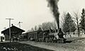
La Moille CB&Q Depot around 1920
-
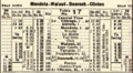
A 1923 train schedule showing a stop at La Moille

See also
 In Spanish: La Moille (Illinois) para niños
