
Lake Parramatta facts for kids
Quick facts for kids Lake Parramatta |
|
|---|---|

|
|

Location of Lake Parramatta
in Greater Sydney |
|
| Country | Australia |
| Location | North Parramatta, Sydney |
| Coordinates | 33°47′24″S 151°00′27″E / 33.79000°S 151.00750°E |
| Purpose | Domestic |
| Status | Decommissioned |
| Construction began | 1855 |
| Opening date | September 1856 |
| Construction cost | £17,000 |
| Owner(s) | City of Parramatta |
| Dam and spillways | |
| Type of dam | Arch dam |
| Impounds | Hunts Creek |
| Height | 15 m (49 ft) |
| Reservoir | |
| Creates | Lake Parramatta |
| Total capacity | 485 ML (17.1×10⁶ cu ft) |
| Active capacity | 450 ML (16×106 cu ft) |
| Catchment area | 8 km2 (3.1 sq mi) |
| Surface area | 10.5 ha (26 acres) |
| Designations | |
|---|---|
| Official name | Lake Parramatta Dam |
| Designated | 23 March 2012 |
| Reference no. | 01879 |
Lake Parramatta is a special place in North Parramatta, Sydney, Australia. It's a man-made lake and a popular spot for fun activities. The lake was created by a dam built across Hunts Creek, finished in 1856. This dam was made of masonry (stone blocks) and shaped like an arch.
For many years, the dam provided water for homes in Parramatta. It stopped being used for water supply in 1909. Now, Lake Parramatta and the land around it are a beautiful nature reserve where people can relax and enjoy the outdoors.
The reserve covers about 73-hectare (180-acre) of bushland, which is the biggest natural area left in the Parramatta region. The water that flows into Lake Parramatta comes from an 8-square-kilometre (3.1 sq mi) area, bordered by North Rocks Road, Pennant Hills Road, and Hunts Creek. The dam wall is 15 metres (49 ft) tall, and the lake can hold up to 485 megalitres (17.1×10⁶ cu ft) of water, covering an area of about 10.5 hectares (26 acres).
This dam is very important! It was one of the first engineered dams built since Roman times (around 100 BC). It was also the very first dam of its kind in Australia. What's more, it was only the second arch dam in the world to be built using special calculations. The dam wall is now listed on the New South Wales State Heritage Register because of its historical importance in dam building. It was added to this list on March 23, 2012.
In 2012, Lake Parramatta Reserve was officially named a 'Wildlife Refuge'. This means it's a protected area for many different animals and plants, including some rare species. People used to swim in the lake between 1920 and 1940. After being closed for a long time due to water quality issues, swimming was allowed again in 2015. You can enter the reserve from Lackey Street in North Parramatta.
Contents
A Look Back: Lake Parramatta's History
First People and the Land
The land around Lake Parramatta belongs to the Burramatagal and Bidjigal clans of the Darug people. These are Indigenous Australians who have lived here for a very long time. We know they used this area because there are signs of their presence, like rock shelters, hand stencils, and tools. It's possible that some of their ancient sites were covered when the dam was built in the 1850s.
This area was important to Aboriginal people because it had plenty of fresh water and many different types of food. Records from 1804 show that people enjoyed using the Reserve, especially around Hunts Creek.
Building the Dam
For many years, Parramatta got its water from the Parramatta River. In 1815, a public well was dug. Then, in 1818, Governor Macquarie ordered a dam to be built across the river. This was called the Town Dam, and it held a lot of water. It's still there today near Lennox Bridge.
But as Parramatta grew, the river water became dirty, and there wasn't enough of it. By 1847, about 4,500 people lived there, and they needed more clean water. People argued about where to build a new dam: some wanted it on Toongabbie Creek, others on Hunts Creek.
In 1849, citizens asked the Governor for money to build a new water supply. The government gave them some money, and a group of citizens called the Water Committee was formed to manage the project. After much discussion, the Surveyor General, Sir Thomas Mitchell, suggested Hunts Creek.
Plans were made for a "circular" (arch) dam. The first few contractors didn't finish the job. A new Water Committee was formed, and they hired Captain Percy Simpson to prepare new plans. Later, Edward Orpen Moriarty, a civil engineer, took over supervising the work.
In November 1853, a contractor named W. Randle was chosen. Before building the dam, workers had to cut and shape stones from a nearby quarry. On June 8, 1855, the first stone was officially laid in the dam wall by James Pye, who had strongly supported the Hunts Creek plan.
About 150 men worked day and night on the dam. The project cost about £17,000 (around $34,000). The dam was finished in September 1856.
The dam was built as a curved arch, with the water side being straight up. It was 12.5 metres (41 ft) high, 4.5 metres (15 ft) thick at the bottom, and 2.4 metres (7 ft 10 in) thick at the top. It was made from solid sandstone blocks taken from the creek area. Each block was carefully shaped.
To make sure the dam was watertight, the stone blocks were joined with special cement. Two different types of cement were brought from England: Roman cement for parts touching the water and Portland cement for other areas.
For the next 25 years, the dam mainly topped up the old Town Dam and was used as a swimming spot for boys. It wasn't until 1881 that a system of pipes and pumps was built to deliver water from Lake Parramatta directly to homes in the town.
By the 1890s, Parramatta's population grew to 13,000. During dry years, the lake sometimes ran low. So, in 1898, the dam wall was made taller by 3.3 metres (11 ft). The original overflow channel was closed, and floods could now pass over the raised dam top.
In 1909, Lake Parramatta stopped supplying water to the town because Parramatta was connected to Sydney's main water system. In the 1920s and 1930s, the reserve became a popular place for picnics and swimming. It even had its own life-saving club! Today, the Hunts Creek water reserve is managed by the Parramatta Council as a public recreation area, known as Lake Parramatta Reserve.
What Does the Dam Look Like?
The dam is located on Hunts Creek, inside the Lake Parramatta Reserve. It's about 1.5 kilometres (0.93 mi) north of the center of Parramatta.
Lake Parramatta Dam is a curved stone dam with a straight water-facing side. The original wall, built in 1856, was 12.5 metres (41 ft) high. It was 4.5 metres (15 ft) thick at the bottom and 2.4 metres (7 ft 10 in) thick at the top. It also had a 0.3 metres (1 ft 0 in) high parapet (a low wall).
The dam was built using solid sandstone blocks dug from the creek. Each block was carefully shaped to fit perfectly. The dam wall also extended about 4 metres (13 ft) into the banks on each side.
The stone blocks were held together with cement mortar to stop water from leaking. Two types of cement were imported from England. Roman cement was used where the joints touched the water, and Portland cement was used everywhere else.
The first way for excess water to flow out was a channel dug at the northern end of the dam. When the dam was made taller, this channel was closed. Now, floods can go over the top of the raised dam.
Considering how old it is, Lake Parramatta Dam is in very good shape. The original sandstone blocks look excellent, with no major signs of wear. The mortar holding the stones together is also very good, with only tiny leaks in a few spots. The dam is strong, holds water well, and is safe.
Nature and Surroundings
The reserve includes 60 hectares (150 acres) of bushland and parkland. It's located less than 2 kilometres (1.2 mi) from the center of Parramatta. Hunts Creek, the main waterway flowing into the reserve, is a branch of the Parramatta River.
The reserve's edges are next to suburban areas, Hunts Creek, private bushland, and playing fields of The King's School.
The geology of Lake Parramatta is interesting. It sits where two different rock types meet: Wianamatta shale and Hawkesbury sandstone. This mix creates different types of plant communities. You can find sandstone blue-gum forests, iron bark trees, and plants typical of the Cumberland Plain Woodland. Some coastal plants like Banksia serrata also grow here.
Fun Things to Do at Lake Parramatta
When the dam was no longer needed for water supply in 1909, Lake Parramatta and its surroundings were given to the City of Parramatta to be used as a recreational area. Between 1920 and 1940, the lake was a very popular swimming hole. At one point, it had the biggest inland freshwater lifesaving club in Australia! However, by the late 1980s, signs were put up saying "No Swimming" because the water quality wasn't consistently good.
In 2006, the City of Parramatta allowed limited swimming again. They decided to only permit swimming on special event days. The first event, called the Freshwater Festival, was held on December 3, 2006. It included swimming races and public swimming, supervised by the Royal Life Saving Society Australia.
On January 24, 2015, Lake Parramatta officially became a designated swimming spot once more! There's an area marked with buoys for swimming, and lifeguards are on duty from 9 am to 5 pm on weekends and public holidays during the warm season.
The reserve around the swimming area has lots of other fun things to do. You can walk on scenic tracks through the bushland, use barbecue areas, or let kids play in the playgrounds. There's also a restaurant. Plus, visitors can even rent boats to explore the natural habitat on the lake.
How to Get There
Getting to Lake Parramatta by road can be a bit tricky because it's tucked away in suburban streets. Many Sydneysiders don't even know about it! To get there, you can take Bourke Street off Church Street in Parramatta, then turn onto Lacey Street, and then Illawong Drive. Illawong Drive goes into the reserve and follows the eastern side of the lake.
If you're traveling by bus from the Parramatta Bus Interchange, the CDC NSW route 609 is an option. The closest Sydney Trains station is at Parramatta.
Why Lake Parramatta Dam is Special
Lake Parramatta Dam holds a very important place in Australia's history. It was the first large dam built in Australia, finished in 1856. It was built around the same time as modern arch dams in Europe, and probably without knowing about them. This makes it a significant landmark in dam technology both in Australia and worldwide.
Here's why it's so special:
- It was the first large dam built in Australia.
- It's the only dam in Australia made of ashlar masonry (finely cut stone blocks) in an arch shape.
- It's believed to be the eleventh earliest single arch dam built in the world since ancient times.
- It's thought to be the only masonry dam in the world that used both Roman and Portland cements in its construction.
- The dam wall is quite thin compared to other structures of its age.
- It was part of one of Australia's earliest suburban water projects and served for 60 years.
- Important engineers and builders of the time were involved: Captain Percy Simpson (likely the designer), Edward Orpen Moriarty (supervised construction), and W. Randle (the contractor).
- The dam used a small amount of material (only 3,000 cubic metres (110,000 cu ft) of masonry) because of its clever arch design. If it had been a different type of dam, it would have needed twice as much material.
- Its design might have inspired later "cylinder" formula dams built by C. W. Darley, which gained international attention.
- The dam's height was raised in 1898 by C. W. Darley. This was part of an early worldwide program of arch dam construction that also attracted international notice.
- The dam was raised by 3.3 metres (11 ft) using a concrete arch, but it didn't harm the original stone structure.
- The excellent design and construction quality mean the dam is still in great condition today, even after 140 years. It can even handle very large floods.
- The dam is still a key part of a popular social and recreational area for Parramatta and nearby communities.
Lake Parramatta was added to the New South Wales State Heritage Register on March 23, 2012, because it met several important criteria.
- Important People Connected to the Dam
Lake Parramatta Dam is linked to four very important people from New South Wales in the mid-to-late 1800s: Captain Percy Simpson, Edward Orpen Moriarty, Cecil West Darley, and William Randle.
- Captain Percy Simpson (1789-1877)
Simpson was a surveyor, engineer, and administrator. He was the first engineer for the dam project and is believed to have designed it. He was known for his engineering skills and for supervising convict labor to build high-quality structures like parts of the Great North Road.
- Edward Orpen Moriarty (1824-1896)
Moriarty was a consulting engineer. He supervised the building of Lake Parramatta Dam and might have changed its design slightly. He also suggested using specific mortars for the stone joints. Later, he became Engineer-in-Chief for Harbours and River Navigation, overseeing many important harbor and water projects in NSW.
- Cecil West Darley (1842-1928)
Cecil Darley became a chief engineer in the Public Works Department. He was responsible for raising Lake Parramatta Dam in 1898. He is famous for designing 13 thin arch dams around the turn of the 20th century, which were well-known internationally.
- William Randle (Randall)
William Randle was the contractor who built the dam. He was also responsible for building Australia's first steam railway in Melbourne and Fort Denison in Sydney Harbour. He was known for his advanced and creative construction methods.
- Amazing Technical Achievements
Lake Parramatta Dam is important for its technical breakthroughs:
- It was one of the very first arch dams ever built (the first in Australia, and the 11th in the world).
- It was very cost-effective, using the least amount of material possible. Most materials were found locally, except for the cements.
- The special cement mortar used for the stone blocks was very innovative. It helped the dam stay strong and watertight for over 140 years.
- The way Randle handled and placed the heavy stone blocks was also innovative. He used a timber frame with a "travelling-jenny" (a type of crane) and a rail line to move the blocks from the quarry to the dam.
- Raising the dam in 1898 with a concrete arch was part of a program of thin arch dam construction in NSW that gained international attention.
- The dam's high quality design and construction mean it still meets modern safety standards even after 140 years.
- Community Connection
The Institution of Engineers has called Lake Parramatta Dam a National Engineering Landmark.
When Lake Parramatta Dam was finished in 1856, it was a huge deal for the people of Parramatta. Their old water source was dirty and unreliable. The new dam provided clean, fresh water, even during droughts. Twenty-five years later, a pumping system brought this water directly to their homes.
Today, the dam is a main feature of Lake Parramatta Reserve. Many tourists and picnickers visit it. The birdlife (especially waterfowl) and native animals around the dam, and fish in the lake, make it a lovely escape from city life. There's also a nature trail around part of the lake.
The Reserve is a popular recreation area in Parramatta. It has a small beach, barbecue areas, picnic spots, parking, a kiosk, and playgrounds for kids. Bushwalking is very popular, and there's even an orienteering track.
In 1958, the Parramatta Council decided to protect the bushland and develop the recreation area. They also applied to make it a "Complete Sanctuary," making it the first wildlife refuge in the Sydney area.
- A Rare and Unique Place
Lake Parramatta Dam is truly rare:
- It's the only masonry arch dam in Australia.
- It was Australia's first large dam, built a year before Melbourne's Yan Yean Dam. (A "large dam" is usually over 15 metres (49 ft) high, which Lake Parramatta Dam became after it was raised in 1898).
- It was the first arch dam in Australia, and it took 40 years before another arch dam was built (Lithgow Dam, 1896).
Even though it's the only masonry arch dam in Australia, it's a cylindrical arch dam, a type that was later built many times using concrete. So, Lake Parramatta Dam is unique in Australia and set an important example for future dam designs.
- A Great Example of Its Kind
The dam is a fantastic example of its type. Its thin shape and curve made it an economical dam for Parramatta. The original stonework is clearly visible from the downstream side and is still in good condition. It shows how skilled stonemasons were at building large water-holding structures. The choice of Roman cement mortar for bonding the stones was excellent, as it has lasted 140 years with very little leakage or damage.
When the dam was raised in 1898, its main character was kept. Even though concrete was used, it blended well. The arch shape remained, the stone layers were copied, and the original stonework stayed visible, much like Fort Denison in Sydney Harbour.
Considering its age, Lake Parramatta Dam is in very good condition. The original sandstone blocks are excellent, with no major signs of wear. The mortar is also very good, with only tiny leaks in a few places.
Gallery
-
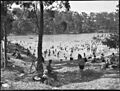
Swimming in the lake, December 1938, photo by Sam Hood
-
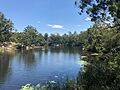
Lake Parramatta, January 2019
-
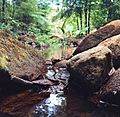
A small stream within the lake


