Lake Santeetlah, North Carolina facts for kids
Quick facts for kids
Lake Santeetlah, North Carolina
|
|
|---|---|
 |
|
| Country | United States |
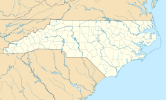
| State | North Carolina |
| County | Graham |
| Area | |
| • Total | 0.19 sq mi (0.50 km2) |
| • Land | 0.19 sq mi (0.50 km2) |
| • Water | 0.00 sq mi (0.00 km2) |
| Elevation | 2,159 ft (658 m) |
| Population
(2020)
|
|
| • Total | 38 |
| • Density | 195.88/sq mi (75.52/km2) |
| Time zone | UTC-5 (Eastern (EST)) |
| • Summer (DST) | UTC-4 (EDT) |
| ZIP code |
28771
|
| Area code(s) | 828 |
| FIPS code | 37-36514 |
| GNIS feature ID | 2352729 |
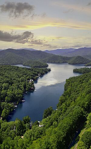
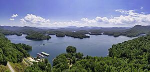
Lake Santeetlah is a small town in Graham County, North Carolina, United States. It's about 6 miles (10 km) northwest of Robbinsville. The town is special because it sits on a piece of land almost completely surrounded by Lake Santeetlah. This lake is also mostly surrounded by the beautiful Nantahala National Forest.
Many of the more than 200 homes in Lake Santeetlah are second homes. Their owners often live permanently in Florida and Georgia. The town was first created in 1989 and was called "Santeetlah." In 1999, its name was changed to "Lake Santeetlah." The number of full-time residents was 67 in 2000 and went down to 38 by 2020.
Contents
Geography of Lake Santeetlah
The town of Lake Santeetlah is located in the middle of Graham County. It sits on a piece of land that sticks out into Lake Santeetlah. This lake is a large reservoir built on the Cheoah River. The Cheoah River flows north and eventually joins the Little Tennessee River.
U.S. Route 129 runs just north of the town. This road leads southeast about 6 miles (10 km) to Robbinsville, which is the main town in the county. Going northwest on the same road, it's about 9 miles (14 km) to Tapoco, where the Little Tennessee River is located.
According to the United States Census Bureau, the town of Lake Santeetlah covers a total area of about 0.19 square miles (0.5 square kilometers). All of this area is land.
History of Lake Santeetlah
Early Settlement and the Dam
Graham County has many mountains. Because of this, it was one of the last places in the eastern United States where European settlers built homes. The town of Robbinsville wasn't officially formed until 1893. By 1915, it only had about 200 people.
The area around the Cheoah River, known as "Santeetlah," had very few settlers. The river valley was later flooded when the Santeetlah Dam was finished in 1928. In 1939, the U.S. Forest Service bought the land where Lake Santeetlah town now stands.
Kenneth Keyes and Thunderbird Estates
The person who really started the idea for Lake Santeetlah was Kenneth S. Keyes, Sr. (1896–1995). He was from Detroit and became a very successful real estate dealer in Miami. He owned many businesses that managed hotels and other properties. He was also a leader in national real estate groups.
In 1947, Mr. Keyes traded some land he owned with the Forest Service. In return, he received the land that is now the town of Lake Santeetlah. He called this property "Thunderbird Estates." It seems he wanted to build a big hotel there. He even hired architects to draw plans. However, Mr. Keyes never built anything. In 1958, he sold the undeveloped land to another developer from Florida.
Developing the Resort and Water Issues
In the early 1960s, a new company called Smoky Mountain Resorts built a lodge and some cabins. This is when the first people started building homes on the north side of the peninsula. The lodge became a central place for the "Thunderbird Mountain Resort." People gathered there for activities like square dancing, movies, and church services.
Roads were built and paved, and a water system was put in place. However, the "Thunderbird Mountain Club Resort" often struggled with money. In 1971, Smoky Mountain Resorts sold its part of the property to W. Bennett Collette. He was known for buying properties that were having financial problems.
Mr. Collette moved the properties between his different companies. By 1973, he made it clear he didn't want to run the water system anymore. The Thunderbird Homeowners Association, formed in 1969, started looking into taking over the water system. This caused some disagreements among the members.
Forming the Town of Santeetlah
The water system became very unreliable. Some property owners even dug their own wells because the water supply was so bad. After some legal issues, the insurance company that owned the property became more open to the idea of the area becoming an official town.
On April 13, 1989, Thunderbird Mountain officially became the Town of Santeetlah. In 1991, the insurance company gave the roads and the water system to the new town. With help from state grants and money from property owners, a new water system was built. The roads were also repaved.
In the same year, a volunteer fire department and a community center were built. Ten years later, in 1998, a town hall was opened on the Fourth of July.
Growth and New Construction
In 1979, North Carolina had stopped new connections to the old water system. This meant that even though homes could still be built if owners dug their own wells, growth was limited. When the new water system was finished in 1995, a new wave of construction began.
Homes built in the 1990s and early 2000s were often much larger and fancier than the simple cabins from the 1960s. The old lodge, which had been used only sometimes, was taken down. Its materials were used for a sales office for a new, fancy lakefront development. For the first time, properties in Lake Santeetlah started selling for over a million dollars.
Population in Lake Santeetlah
| Historical population | |||
|---|---|---|---|
| Census | Pop. | %± | |
| 1990 | 47 | — | |
| 2000 | 67 | 42.6% | |
| 2010 | 45 | −32.8% | |
| 2020 | 38 | −15.6% | |
| U.S. Decennial Census | |||
In the year 2000, there were 67 people living in Lake Santeetlah. These people lived in 38 households, and 25 of those were families. The town had about 332 people per square mile (128 people per square kilometer). Most of the people living there were White (94.03%).
The average household had about 1.76 people, and the average family had about 2.12 people. In terms of age, about 4.5% of the population was under 18. A large portion, 43.3%, was 65 years old or older. The average age of people in the town was 61 years.
Fun Things to Do in Lake Santeetlah
Lake Santeetlah and the Cheoah District of the Nantahala National Forest offer many great ways to have fun outdoors.
Fishing and Boating
The lake is home to many types of fish. You can find smallmouth bass, largemouth bass, walleye, crappie, bream, and lake trout. Santeetlah Marina is the only full-service marina on the lake. The lake has a long shoreline, stretching about 76 miles (122 km).
There are more than 50 simple campsites located around the lake. These sites have a picnic table and a fire ring. They do not have water or toilets, but you also don't need a permit or have to pay a fee to use them.
Hiking and Outdoor Adventures
The Cheoah District has over 200 miles (320 km) of hiking trails. You can even hike about 8 miles (13 km) from Lake Santeetlah to reach the famous Appalachian Trail.
About a mile north of the town is the Cheoah Point Recreation Area. This area has places for swimming, camping, and picnicking. It also has a boat ramp for launching boats.
The nearby Cheoah River is well-known for its exciting whitewater rapids. These are rated as Class IV and V, which means they are very challenging. You can usually experience these rapids about 17 days a year, depending on when water is released from the Santeetlah Dam.
The Tail of the Dragon
Lake Santeetlah is next to a part of U.S. 129 called the Tail of the Dragon. This road is very popular with motorcycle and sports car fans. It's famous for having 318 curves in just 11 miles (18 km), making it a thrilling drive.
See also
 In Spanish: Lake Santeetlah (Carolina del Norte) para niños


