Lakeville, Minnesota facts for kids
Quick facts for kids
Lakeville, Minnesota
|
||
|---|---|---|
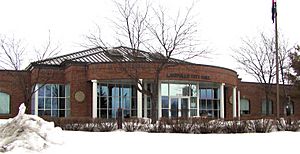
Lakeville City Hall
|
||
|
||
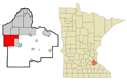
Location within Dakota County, Minnesota
|
||
| Country | United States | |
| State | Minnesota | |
| County | Dakota | |
| Founded | 1855 | |
| Established | 1858 | |
| Incorporated | 1967 | |
| Founded by | J. J. Brackett | |
| Named for | Prairie Lake (now known as Lake Marion) | |
| Government | ||
| • Type | Mayor–council | |
| Area | ||
| • City | 38.35 sq mi (99.33 km2) | |
| • Land | 36.59 sq mi (94.78 km2) | |
| • Water | 1.76 sq mi (4.55 km2) | |
| Elevation | 1,086 ft (331 m) | |
| Population
(2020)
|
||
| • City | 69,490 | |
| • Estimate
(2022)
|
74,553 | |
| • Rank | US: 498th MN: 9th | |
| • Density | 1,898.95/sq mi (733.19/km2) | |
| • Metro | 3,693,729 (US: 16th) | |
| Time zone | UTC-6 (Central (CST)) | |
| • Summer (DST) | UTC-5 (CDT) | |
| ZIP code |
55044
|
|
| Area code(s) | 952 | |
| FIPS code | 27-35180 | |
| GNIS feature ID | 2395614 | |
Lakeville is a growing city located just south of Minneapolis-Saint Paul in Minnesota. It's the largest city in Dakota County, Minnesota, and is about 20 miles (32 km) from downtown Minneapolis and St. Paul. Lakeville started as a busy center for milling and farming. Today, it's one of the fastest-growing cities in the Twin Cities area. In 2020, about 69,490 people lived there, making it Minnesota's tenth-largest city.
Lakeville became well-known in 1910 because of Marion Savage. He built the Dan Patch Railroad Line to serve his fun Antlers Amusement Park. While many people who live in Lakeville travel to Minneapolis or St. Paul for work, Lakeville also has its own big industries. One important area is the Airlake Industrial Park, which even has its own airport!
Contents
Exploring Lakeville's Past
How Lakeville Began
Lakeville started thanks to a military road built between Fort Snelling and forts to the south. In 1855, a man named J. J. Brackett, who carried mail along this road, decided to create a town. He chose a spot halfway between Saint Paul and Saint Peter, next to a lake he called Prairie Lake. This village officially became Lakeville Township in 1858.
The Dan Patch Connection
Lakeville gained fame when Colonel Marion Savage expanded his entertainment business. He built the Antlers Amusement Park in 1910. Savage was already famous because of his amazing racing horse, Dan Patch. Because the park was so popular and Dan Patch was so well-known, Prairie Lake was renamed Lake Marion. The train line that went to the park was also named the Dan Patch Railroad Line.
Early Settlers and Growth
In the early days, Lakeville was mostly farmland, and many of the first settlers were farmers. A large number of them came from Scandinavian countries like Denmark and Norway. Other groups, like the Irish, Scots, and English, also settled there. A local grocery store, Enggren's Grocery, was a main part of downtown from 1900 until it closed in 2006.
Lakeville grew a lot later in the 20th century, like many other suburbs around the Twin Cities. It officially became the City of Lakeville in 1967. For a while, it stayed mostly agricultural. But in the early 2000s, more and more people started moving to Lakeville. This happened because land in other parts of the metropolitan area became very expensive. Lakeville quickly became a "boomtown" with lots of new homes and people.
Lakeville's Location and Climate
Where is Lakeville?
Lakeville covers about 37.83 square miles (98.0 km²). Most of this area is land, with about 1.77 square miles (4.58 km²) being water. You might still see a place called Argonne on maps within Lakeville. This was a settlement project after World War I that didn't work out. It was later redeveloped into typical suburban shops and homes.
Rivers and Waterways
A part of the Vermillion River flows through Lakeville. This river starts just west of the city and flows east across Dakota County. It eventually empties into the Mississippi River. Much of Lakeville's water drains into the Vermillion River. North Creek, another important stream, also starts in northern Lakeville and flows east to meet the Vermillion. The Minnesota Department of Natural Resources has even named the Vermillion River a special trout stream.
Lakeville's Weather
Lakeville has a climate with warm summers and cold, snowy winters. It's known as a humid continental climate.
| Climate data for Lakeville weather station - 2010–2020 | |||||||||||||
|---|---|---|---|---|---|---|---|---|---|---|---|---|---|
| Month | Jan | Feb | Mar | Apr | May | Jun | Jul | Aug | Sep | Oct | Nov | Dec | Year |
| Mean daily maximum °F (°C) | 22.6 (−5.2) |
26.4 (−3.1) |
42.4 (5.8) |
55.0 (12.8) |
68.7 (20.4) |
78.3 (25.7) |
82.8 (28.2) |
80.4 (26.9) |
72.1 (22.3) |
57.2 (14.0) |
41.9 (5.5) |
27.1 (−2.7) |
54.5 (12.5) |
| Daily mean °F (°C) | 16.5 (−8.6) |
19.4 (−7.0) |
34.9 (1.6) |
46.2 (7.9) |
59.2 (15.1) |
68.9 (20.5) |
73.2 (22.9) |
70.9 (21.6) |
63.5 (17.5) |
49.6 (9.8) |
36.1 (2.3) |
22.5 (−5.3) |
46.7 (8.2) |
| Mean daily minimum °F (°C) | 10.4 (−12.0) |
12.2 (−11.0) |
26.8 (−2.9) |
37.4 (3.0) |
49.5 (9.7) |
59.9 (15.5) |
63.9 (17.7) |
61.3 (16.3) |
55.2 (12.9) |
41.9 (5.5) |
29.5 (−1.4) |
18.1 (−7.7) |
38.8 (3.8) |
| Source: weather-online | |||||||||||||
Lakeville's People
How Many People Live Here?
| Historical population | |||
|---|---|---|---|
| Census | Pop. | %± | |
| 1880 | 168 | — | |
| 1890 | 258 | 53.6% | |
| 1900 | 373 | 44.6% | |
| 1910 | 385 | 3.2% | |
| 1920 | 474 | 23.1% | |
| 1930 | 522 | 10.1% | |
| 1940 | 543 | 4.0% | |
| 1950 | 628 | 15.7% | |
| 1960 | 924 | 47.1% | |
| 1970 | 7,556 | 717.7% | |
| 1980 | 14,790 | 95.7% | |
| 1990 | 24,854 | 68.0% | |
| 2000 | 43,128 | 73.5% | |
| 2010 | 55,954 | 29.7% | |
| 2020 | 69,490 | 24.2% | |
| 2022 (est.) | 74,553 | 33.2% | |
| U.S. Decennial Census 2020 Census |
|||
| Historical population | |||
|---|---|---|---|
| Census | Pop. | %± | |
| 1860 | 598 | — | |
| 1870 | 780 | 30.4% | |
| 1880 | 802 | 2.8% | |
| 1890 | 701 | −12.6% | |
| 1900 | 805 | 14.8% | |
| 1910 | 841 | 4.5% | |
| 1920 | 744 | −11.5% | |
| 1930 | 999 | 34.3% | |
| 1940 | 1,268 | 26.9% | |
| 1950 | 1,356 | 6.9% | |
| 1960 | 2,123 | 56.6% | |
| U.S. Census for Lakeville Township | |||
In 2020, Lakeville had 69,490 people living in the city. The population has grown a lot over the years. By 2022, it was estimated to be around 74,553 people.
Who Lives in Lakeville?
In 2020, most people in Lakeville were White (81.7%). There were also African American (4.5%), Asian (6.0%), and Native American (0.4%) residents. About 5.1% of people were from two or more races. People of Hispanic or Latino background made up 5.3% of the population.
The city has many families. In 2020, about 56% of households had children under 18 living with them. The average household had 2.8 people. The median age in Lakeville is 38 years old. About 31% of the population is under 19, and 31% is between 30 and 49 years old. The population is almost evenly split between males (51%) and females (49%).
Lakeville's Economy
Businesses and Jobs
Lakeville is home to the Airlake Industrial Park, which is one of the largest industrial parks in Minnesota. It covers 1,500 acres and has about 200 companies. These companies employ around 4,500 people. The park was named "Airlake" because it has an airport ("air") and is near Lake Marion ("lake").
The Airlake Airport helps bring in business. It has one runway and is managed by the Metropolitan Airports Commission. This airport helps reduce air traffic at bigger airports by handling smaller planes. The FAA (Federal Aviation Administration) also has a control center nearby that manages air traffic for Minnesota and other states.
Farming and Food
Even though Lakeville is growing, large farms still operate here. They mostly grow corn and soybeans, and some raise dairy cattle. A big food company, Post Consumer Brands, has had its main office in Lakeville since 2015.
Fun and Learning in Lakeville
Parks and Recreation
Lakeville offers many ways to have fun outdoors! As of 2020, the city has over 3,000 acres of parks and natural areas. The Parks & Recreation Department takes care of 62 public places. These include parks, sports fields, playgrounds, trails, tennis courts, skating rinks, and picnic areas. There are also places for fishing, swimming beaches, and the Lakeville Area Arts Center.
Some popular parks include:
- Antlers Park: This park has a big swimming beach, volleyball courts, baseball fields, a playground, and picnic areas. You can also fish from the pier or play horseshoes.
- Orchard Lake Beach: Here you'll find a picnic area, shore fishing, playground equipment, and volleyball courts.
- Valley Lake Beach: This park has a playground, picnic area, a walking trail around the lake, and a fishing pier.
Education in Lakeville
Lakeville is served by three different school districts. Most students attend schools in the Lakeville Area School District 194. Parts of northern and eastern Lakeville are served by Independent School District 196 (Rosemount-Apple Valley-Eagan) and Farmington School District 192.
Lakeville has two large high schools, each with nearly 2,000 students:
- Lakeville North
- Lakeville South (opened in 2005)
There are also eight public elementary schools and three public middle schools. Students from Century Middle School usually go to Lakeville North, while McGuire Middle School students go to Lakeville South. Kenwood Middle School students might go to either, depending on where they live. Some students can also choose to attend public schools in other districts.
Getting Around Lakeville
Roads and Highways
Lakeville is easy to reach by car. Interstate 35 runs directly through the city. Cedar Avenue/MN 77 is also nearby to the east.
Railroads
A short-line railroad company called Progressive Rail is based in Lakeville. They own some old train tracks between Lakeville and Northfield. Another set of tracks, owned by Canadian Pacific Railway, runs between Lakeville and Savage, but it hasn't been used since the 1990s.
Famous People from Lakeville
Lakeville has been home to many talented people, including:
- Elisabeth Bachman, an Olympic volleyball player
- Rachel Banham, a WNBA basketball player
- Paul Krause, a Pro Football Hall of Famer
- Chelsea Laden, an ice hockey goalie and TV star
- Charlie Lindgren, a professional ice hockey goalie
- J.P. Macura, an NBA basketball player
- Jake Oettinger, a professional ice hockey goalie
- Ryan Poehling, a professional ice hockey player
- Jordan Schroeder, a professional ice hockey player
- Brady Skjei, a professional ice hockey player
- Regan Smith, an Olympic gold medalist in swimming
See also
 In Spanish: Lakeville (Minnesota) para niños
 | Claudette Colvin |
 | Myrlie Evers-Williams |
 | Alberta Odell Jones |


