Lameroo facts for kids
Quick facts for kids LamerooSouth Australia |
|||||||||||||||
|---|---|---|---|---|---|---|---|---|---|---|---|---|---|---|---|

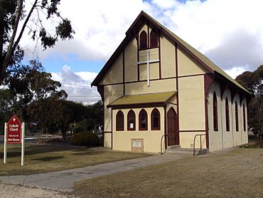
Irish Martyrs Catholic Church, Lameroo
|
|||||||||||||||
| Established | 17 November 1904 (town) 2 August 1999 (locality) |
||||||||||||||
| Postcode(s) | 5302 | ||||||||||||||
| Elevation | 98 m (322 ft)(railway station) | ||||||||||||||
| Time zone | ACST (UTC+9:30) | ||||||||||||||
| • Summer (DST) | ACST (UTC+10:30) | ||||||||||||||
| Location |
|
||||||||||||||
| LGA(s) | Southern Mallee District Council | ||||||||||||||
| Region | Murray and Mallee | ||||||||||||||
| County | Chandos | ||||||||||||||
| State electorate(s) | Hammond | ||||||||||||||
| Federal Division(s) | Barker | ||||||||||||||
|
|||||||||||||||
|
|||||||||||||||
| Footnotes | Adjoining localities | ||||||||||||||
Lameroo is a town located in the Murray Mallee area of South Australia. It sits on the Mallee Highway and the Pinnaroo railway line. The town is about 40 kilometers west of the Victorian border. It is also about 210 kilometers east of Adelaide, the capital city of South Australia.
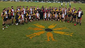
Lameroo is an important service center for the farms around it. Farmers in this area mainly grow grain and raise sheep. The town's school, Lameroo Regional Community School, serves students from Lameroo and nearby towns like Geranium, Parrakie, and Parilla. Lameroo is also home to the Lameroo Hawks Football Club.
Contents
History of Lameroo
The land in the Murray Mallee region was first used for grazing animals in the late 1850s. For about 20 years, only a few people lived there. In 1884, a well was dug at a place then called Wow Wow Plain. This helped people settle there permanently.
The land was mapped out in 1894. The first maps of Wow Wow Plain made sure each farm had some open land ready for planting crops. The town area was officially set aside in 1894, and the government dug another well.
How Lameroo Got Its Name
The town was named Lameroo in 1904. The name was suggested by J.M. Johnston. He had worked on the Overland Telegraph Line and heard the word in Darwin. He liked the sound of it, as it was the name of Lameroo Beach there.
Much of the land that became the District Council of Lameroo was first given to farmers in 1858. This area is now the western part of the Southern Mallee District Council. In 2006, Lameroo celebrated its 100th birthday. This marked 100 years since the train line was built through the town.
Historic Buildings in Lameroo
Two important buildings in Lameroo are listed on the South Australian Heritage Register. These are the old Bank Manager's Residence and the Irish Martyrs Catholic Church. These buildings are protected because of their historical importance.
The Lameroo Railway Line
The Pinnaroo railway line opened in Lameroo in 1906. At first, it carried many different goods and also passengers. Later, the line was only used to transport bulk grain. Trains would empty the grain silos in Lameroo. After mid-2015, the train line stopped being used. Now, all the grain from the harvest is moved by road.
Local Media and Newspapers
Lameroo was once home to a newspaper called the Pinnaroo Country News. It was published from 1908 to 1922. This was the first country newspaper started by James Barclay and William Macfarlane. After 1911, another newspaper, Pinnaroo and Border Times, started and became more popular.
Lameroo also had two other short-lived newspapers: the Lameroo Weekly News in 1922 and the Lameroo Mail in 1927.
Attractions and Nature
Lameroo is located between two important natural areas. To the north is the Billiatt Wilderness Protection Area. To the south is the Ngarkat Conservation Park. Both of these areas are great for people who enjoy hiking and nature.
Exploring Local Wildlife and Plants
In spring, the Ngarkat Conservation Park is filled with beautiful native Australian wildflowers. The Billiatt Wilderness Protection Area is home to native animals like kangaroos and mallee fowl. These protected areas help keep the local wildlife and plants safe.
See also
 In Spanish: Lameroo para niños


