
Laupen facts for kids
Quick facts for kids
Laupen
|
||
|---|---|---|
 |
||
|
||

Laupen
Location in Switzerland

Laupen
Location in Canton of Bern
|
||
| Country | Switzerland | |
| Canton | Bern | |
| District | Laupen | |
| Area | ||
| • Total | 4.13 km2 (1.59 sq mi) | |
| Elevation | 489 m (1,604 ft) | |
| Population
(Dec 2020 )
|
||
| • Total | 3,230 | |
| • Density | 782.1/km2 (2,026/sq mi) | |
| Postal code |
3177
|
|
| Surrounded by | Bösingen (FR), Ferenbalm, Gurmels (FR), Kriechenwil, Mühleberg, Neuenegg | |

Laupen is a small town, also called a municipality, in Switzerland. It is located in the Bern-Mittelland area of the canton of Bern. Laupen is the main town of its district.
Contents
History of Laupen


Laupen was first mentioned in old writings between 1130 and 1133. Back then, it was called Loupa. Later, in 1173, it was known as Loyes in French. By 1352, it was recorded as Louppen in Latin.
The Battle of Laupen
Laupen was the site of an important battle in 1339. This was the Battle of Laupen. In this battle, the town of Bern and its allies, the Swiss Confederation, won a big victory against the town of Fribourg.
This battle was important because it showed how new foot soldier tactics were becoming stronger than old-style heavy cavalry (knights). After this victory, Bern joined the Swiss Confederation in 1353.
Early Settlements in Laupen
People have lived in the Laupen area for a very long time. Archeologists found Bronze Age sword blades in a gravel pit. They also found two old grave mounds.
Coins, weapons, and pots from the Roman era were found north of Laupen. Traces of a Roman road were also discovered.
Laupen Castle

Laupen Castle was built between the 10th and 13th centuries. It was one of many castles built by the empire along the Sense and Saane rivers. The castle has a strong main tower, called a keep, and a ring wall. It sits on a high rock above the Sense river.
The castle was once a home for kings. Then, it became the home of a count. Later, it was owned by the Counts of Kyburg. After them, the Habsburgs and the Counts of Savoy fought over it. The Habsburgs won and put a special officer, called a castellan, in charge of the castle in 1269.
In 1324, Bern bought the castle and its lands. When the emperor could not pay back a loan, Laupen became the first area, or bailiwick, controlled by Bern.
Laupen as Part of Bern
After Laupen joined the Canton of Bern, the castle became Bern's local government office. The castle was updated and renovated many times over the centuries. Until 1798, a special officer called a bailiff lived there.
The town of Laupen itself got its own city walls in the 13th century. In 1275, King Rudolf I gave Laupen a special town charter. This meant Laupen could govern itself, similar to Bern.
Laupen became fully controlled by Bern in 1324. The town's leaders, like the mayor and council, reported to Bern's governor.
Town Development
Until the 15th century, Laupen was an important stop on the road between Bern and Fribourg. Bern built a bridge over the Sarine river in 1324. However, floods often destroyed it. Later, other bridges were built nearby, so the Sarine bridge in Laupen was not rebuilt.
Without easy trade routes, the town did not grow much. This meant many old buildings from the 16th and 17th centuries are still standing. The old town has two rows of houses and a church around a triangular market square. Parts of the old city walls and the Freiburgtor (Fribourg gate) from the 15th century can still be seen.
In the late 1800s, the arrival of the railroad and new roads helped Laupen's economy grow. Today, many people work in services like restaurants, or in manufacturing, such as printing and metal work.
Geography of Laupen

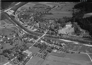
Laupen covers an area of about 4.12 square kilometers (1.59 square miles). A large part of this land, about 38.6%, is used for farming. Forests cover about 29.9% of the area. Buildings and roads make up about 25.5% of the land. Rivers and lakes cover about 5.1%.
Laupen is located on the right side of the Sense River. This is close to where the Sense River flows into the Saane River.
Coat of arms
The blazon of Laupen's coat of arms shows a green linden tree with seven leaves on a silver background.
People in Laupen (Demographics)

Laupen has a population of about 3,300 people. Around 10% of the people living in Laupen are from other countries. Over the past ten years, the population has grown slightly.
Most people in Laupen (about 92%) speak German as their main language. A smaller number speak Italian or French.
In 2008, about 49% of the population was male and 51% was female. Many people living in Laupen were born there or in the same canton. About 10% of the population was born outside of Switzerland.
About 23.6% of the population are children and teenagers (0–19 years old). Adults (20–64 years old) make up 61%, and seniors (over 64 years old) make up 15.4%.
Most households in Laupen have about 2.3 people. There are also many households where only one person lives.
Important Heritage Sites

Laupen Castle is a very important historical site in Switzerland. It is listed as a heritage site of national significance. The entire town of Laupen is also part of the Inventory of Swiss Heritage Sites, meaning it has important historical value.
Economy
In 2010, the unemployment rate in Laupen was 2.8%. This means a small number of people who wanted to work could not find jobs.
In 2008, about 13 people worked in farming (the primary sector). About 205 people worked in manufacturing and construction (the secondary sector). The largest number of people, 837, worked in services (the tertiary sector). This includes jobs in shops, restaurants, transportation, and healthcare.
Many people who live in Laupen travel to other towns for work. Also, many people from other towns come to Laupen to work. About 23.8% of workers use public transport, and 47.9% use a private car to get to work.
Transport

Laupen has a train station called Laupen BE. It is on the Flamatt–Laupen line, which connects Laupen to other towns by train.
Religion
Based on a 2000 survey, most people in Laupen belong to the Swiss Reformed Church (about 67%). About 18% are Roman Catholic. Smaller numbers of people belong to other Christian churches, or are Islamic, Buddhist, or Hindu. About 6.7% of the population do not belong to any church.
Weather
Laupen has about 126 days of rain or snow each year. On average, it gets about 1002 millimeters (39 inches) of rain or snow annually. June is usually the wettest month, with about 111 millimeters (4.4 inches) of rain or snow. February is the driest month, with about 62 millimeters (2.4 inches) of precipitation.
Education
In Laupen, about 42% of the people have finished high school. About 13% have gone on to higher education, like university.
The schools in Bern Canton, where Laupen is located, have a specific system. Children start with one year of kindergarten. Then they go to primary school for six years. After that, they attend three years of lower secondary school. Students are grouped by their abilities. After secondary school, students can continue their education or start an apprenticeship.
In the 2009–10 school year, 326 students attended schools in Laupen. There were 49 kindergarten students, 171 primary students, and 115 lower secondary students. Some students were from other countries or had a different first language than the classroom language.
Laupen has two libraries: the Schul- und Gemeindebibliothek Laupen and the Bibliothek Laupen. In 2008, these libraries had over 15,000 books and other media. They loaned out almost 29,000 items that year.
Notable people
- Ernst Wilczek (1867 in Laupen – 1948) – A Swiss botanist and pharmacist.
See also
 In Spanish: Laupen para niños
