
Leadville mining district facts for kids

The Leadville mining district in Colorado was once the state's top producer of silver. It also holds one of the world's biggest deposits of lead, zinc, and silver. Oro City, an early gold mining town, was located near Leadville. It was known for one of Colorado's richest gold discoveries. Miners found about 120,000 to 150,000 ounces of gold there. This gold was worth about $2.5 to $3 million at the time.
By 1963, the district had produced huge amounts of metals. This included 240 million ounces of silver and 3 million ounces of gold. It also yielded 987 million tons of lead, 712 million tons of zinc, and 48 million tons of copper. The area also produced bismuth and iron-manganese ore.
Contents
History of Mining in Leadville


,_1833-1880.jpg)
The Gold Rush Begins
Gold was first found in the Leadville area in late 1859. This was during the famous Pike's Peak Gold Rush. The first discovery wasn't very exciting. But on April 26, 1860, a miner named Abe Lee found a lot of gold in California Gulch. This was about a mile east of Leadville. Soon after, Oro City was founded at these new gold sites.
By July 1860, a big gold rush was happening. The town and nearby areas quickly grew to 10,000 people. An estimated $2 million in gold was taken from California Gulch and Iowa Gulch that first summer. This amount would be worth about $70 million today. However, within a few years, most of the easy-to-find gold was gone. Oro City's population dropped to only a few hundred people.
From Gold to Silver
In 1874, gold miners at Oro City noticed a heavy, black sand. This sand was making it hard to find gold. They had it tested and found it was a lead mineral called cerussite. This cerussite also contained a lot of silver. Prospectors then followed the cerussite to where it came from. By 1876, they had found several large silver-lead deposits. This discovery started the Colorado Silver Boom.
Unlike gold, which was found in loose dirt (called placer mining), the silver was in veins deep within the rock. This meant miners had to dig deep into the ground. This type of mining is called hard rock mining.
Leadville's Silver Boom
The city of Leadville was founded in 1877. It was started by mine owners Horace Austin Warner Tabor and August Meyer. By 1878, Leadville became the main town of Lake County. The town was likely named Leadville because lead was a major mineral found there.
By 1880, millions of dollars were being made. Leadville became one of the world's largest silver mining towns. Its population grew to over 40,000 people. Leadville became Colorado's biggest mining camp. It was the second-largest town in Colorado, after Denver.
Life in Leadville was tough. The town became very crowded. It was hard to find enough food and supplies. Everything had to be brought in by pack mules or stagecoach. Places to sleep were very expensive. Leadville is a high mountain town, so winters were long and very cold. Many miners suffered from the cold and lack of food. Crime was also a big problem, and law enforcement struggled to control it.
Many small shanty towns grew up around Leadville. These included Poverty Flats, Slabtown, Finntown, and Boughtown. "Boughtown" got its name from the many pine trees in the area. Miners built their homes there using four posts covered with pine branches.

The End of the Silver Boom
In 1893, a law called the Sherman Silver Purchase Act was canceled. This caused a big panic in Leadville and other silver towns in Colorado. The price of silver dropped very quickly. Many silver mines had to close down. Mining companies then started to rely more on income from lead and zinc.

The Sherman Mine produced over 10 million ounces of silver. Most of this was between 1968 and 1982. This silver was worth over $300 million. The last active mine in the Leadville District, the Black Cloud mine, closed in 1999. Even though there is no active mining now, the area has a long history. Over 2,800 mine claims were filed there. There are also over 1,600 test sites, 1,300 shafts, and 155 tunnels. The silver produced from Leadville mines was worth an estimated $512 million by 1967. This would be about $4.7 billion today.
Geology of the Leadville District

Leadville is located in the middle of the Colorado Mineral Belt (CMB). This is a 50-mile-wide strip that stretches 300 miles north and south. The minerals in the CMB mostly came from hot, molten rock (magma) that pushed up from deep underground. The main ores found in the CMB were mixed metal sulfide minerals. These included pyrite, galena, sphalerite, chalcopyrite, and also gold, silver, and copper. During the last ice age, natural gold was freed from the rock. This made it available for placer mining.
The Leadville district has many faults (cracks in the Earth's crust). It also has many areas where hot rock pushed up. This area is on the east side of the Arkansas River valley.

Silver is found with manganese and lead. It is in veins and other types of deposits within certain rock layers. These layers include the Leadville Limestone, the Dyer Dolomite, and the Manitou Dolomite. The main ore minerals are pyrite, sphalerite, and galena. In the upper parts of the mines, these minerals changed into cerussite, anglesite, and smithsonite. Leadville was Colorado's biggest silver-producing area.
Environmental Impact of Mining

For over 130 years, mining and metal processing in Leadville created a lot of waste. This waste contained metals like arsenic and lead. These metals were harmful to people and the environment. The waste was left on the ground. It then washed into streams and leaked into surface water and groundwater.
Because of this pollution, the site was added to the U.S. Environmental Protection Agency (EPA) list of priority cleanup sites in 1983. Cleanup efforts began in the mid-1980s. Since 1995, the EPA and the companies responsible have worked to clean up the area. They have moved and covered over 350,000 cubic yards of contaminated soil and waste. The cleanup has included stopping acid mine runoff, covering waste piles, and cleaning up homes. By September 2011, most of the cleanup was finished. The risk of exposure to pollution is now low. However, pregnant women, nursing mothers, and young children are still advised to have their blood-lead levels checked.
Mine Drainage Tunnels
As mines got deeper, keeping water out became very expensive. To solve this, two long tunnels were dug. These tunnels allowed water to drain out by gravity. Water from both tunnels eventually flows into the Arkansas River.
Yak Tunnel
The Yak tunnel is 3.5 miles long. It was built between 1895 and 1923 to drain the southern part of the mining district. Its exit is in California Gulch, east of Leadville. This tunnel became part of the cleanup site in 1983. In October 1985, a large rush of water from the Yak tunnel reached the Arkansas River. This raised the level of dissolved metals in the river for many miles downstream. Since June 1991, the tunnel's owner, ASARCO, has treated the water to remove metals.
Leadville Tunnel
The Leadville tunnel was started in 1943. It was built to drain mines in the northern part of the district. This helped increase metal production during World War II. The tunnel's exit is north of Leadville, on the East Fork of the Arkansas River. In 1959, the US Bureau of Reclamation bought the tunnel for $1.00. They wanted to use it as a source of irrigation water for farms.
Since March 1992, the Bureau of Reclamation has treated the water from this tunnel. This removes dissolved metals and makes the water safe. In 1995, parts of the tunnel collapsed. This partly blocked the water flow. It created a large underground reservoir of about 1 billion gallons of water. People worried that if the blockage suddenly broke, a huge amount of polluted water would rush out. This could overwhelm the treatment facilities and flow into the Arkansas River. The rising water level inside the tunnel also caused polluted water to leak out through springs.
Officials had different opinions about the danger. Some worried about a "national catastrophe." Others said there was "no imminent public safety hazard." In June 2008, a report concluded that a sudden burst of water was unlikely. In February 2008, the EPA started pumping water from the tunnel system. This helped reduce the water pressure behind the blockage. The water pumped out was clean enough to go into the Arkansas River without treatment.
Things to See and Do


Mineral Belt National Recreation Trail
The Mineral Belt National Recreation Trail is a fun way to explore the area. It's an 11.6-mile trail for biking and walking. It loops around Leadville and goes through the historic mining district. Part of the trail follows old railroad beds used by mining camps. Signs along the way share interesting facts about Leadville's past.
Route of the Silver Kings
The "Route of the Silver Kings" is a driving tour. It covers 20 square miles of the historic mining district around Leadville. The tour includes old mines, power plants, ghost towns, and mining camps.
National Mining Hall of Fame and Museum
The National Mining Hall of Fame and Museum is a large museum. It has many exhibits about mining. You can see a detailed model railroad and a replica of an underground mine. There's also a "Gold Rush" room with many real gold samples. The museum has a big collection of minerals and a mining art gallery.
Matchless Mine and Cabin
The Matchless mine and cabin was once the home of Baby Doe Tabor, a famous figure from Leadville's history. It is open for visitors during the summer.
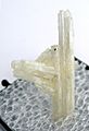
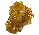
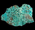
Gallery of Leadville Area Minerals
-
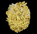
Gold-quartz
-
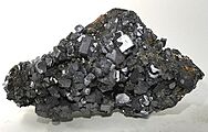
Galena—Black Cloud Mine
-
Cerussite
-
Baryte
-
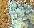
Cerussite-rosasite-azurite
-
Wulfenite-rosasite
-
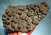
Goethite
-
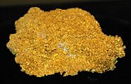
Gold - Little Jonny Mine


_(17161825282).jpg)
