Left Hand Creek (Colorado) facts for kids
Quick facts for kids Left Hand Creek |
|
|---|---|

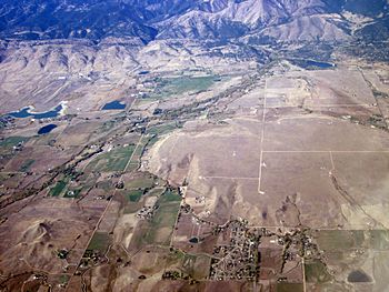
Left Hand Creek and Canyon. Aerial photo by Doc Searls
|
|
| Physical characteristics | |
| Main source | 40°04′00″N 105°34′21″W / 40.06667°N 105.57250°W |
| River mouth | Confluence with Saint Vrain 4,924 ft (1,501 m) 40°09′18″N 105°05′15″W / 40.15500°N 105.08750°W |
| Basin features | |
| Progression | Saint Vrain—South Platte—Platte— Missouri—Mississippi |
Left Hand Creek is a cool stream in Boulder County, Colorado, in the United States. It flows into Saint Vrain Creek and is about 33.9 miles (54.6 km) long. The creek starts high up in the mountains. It then flows through a deep valley called Left Hand Canyon.
Left Hand Creek begins at Left Hand Park Reservoir. This is near Niwot Mountain. The creek flows through a steep gorge. It passes below the town of Ward. After leaving the mountains, it crosses open ranch lands. It flows north of Niwot. Finally, it joins Saint Vrain Creek near Longmont.
Contents
Exploring Left Hand Canyon
Left Hand Canyon is a popular spot for outdoor fun. Many people enjoy riding their bikes on the roads here. It is also a great place for hiking. Some parts of the creek are good for whitewater kayaking. Rock climbing is another exciting activity.
Parks and Wildlife
The canyon has several parks. These are part of the City of Boulder Open Space. You can find them along the road that goes into the canyon. This road starts from U.S. Highway 36. The tall canyon walls are home to birds of prey. These are birds like hawks and eagles. To protect these birds, some climbing areas are closed in late winter and early spring. This is when the birds are nesting.
The Creek's Name and History
Left Hand Creek was named after a famous Native American leader. He was Chief Left Hand of the Arapaho people.
Gold Rush Discovery
In 1859, people rushed to Colorado looking for gold. This was called the Colorado Gold Rush. During this time, gold was found in Left Hand Canyon. The discovery happened at a place called Gold Hill. This spot is about halfway up the canyon.
The 2013 Flood Event
Left Hand Creek had a very big flood in September 2013. This flood caused a lot of damage. Sadly, one person in the town of Jamestown died. This happened because of mud and rocks flowing from a nearby ravine.
Recovery and Restoration
The flood changed the creek bed in many places. It moved a lot of sand and rocks around. After the flood, people worked hard to fix things. They helped the town of Jamestown and other canyon residents. This work was still going on in 2017. A group called the Lefthand Watershed Oversight Group helps. They are a non-profit organization. Their goal is to check, protect, and improve the Left Hand Creek Watershed.
Whitewater Kayaking Adventures
Before 2000, not many people knew about kayaking on Left Hand Creek. It became more known after that. The first people to kayak here were Brook Aitken, Chris McEniry, and Craig D. Irwin in 1998.
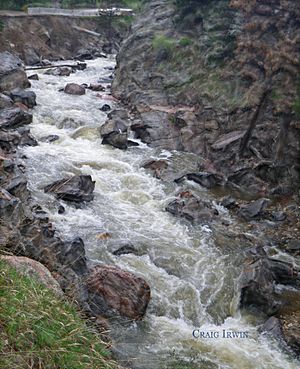
These kayakers entered a challenging part of the creek. It's called the Class V mini-gorge. They went through a small tunnel under Left Hand Canyon Drive. From there, they faced a tight and twisty section. It was full of large rocks and small waterfalls. This mini-gorge is below the road. Sometimes, it can have lots of tree branches and logs. The kayak run on Left Hand Creek is short but full of action!
Parking Information
The City of Boulder Mountain Parks and Open Space has a parking area. It is located at Buckingham Park.
 | William M. Jackson |
 | Juan E. Gilbert |
 | Neil deGrasse Tyson |


