
Leo Belgicus facts for kids
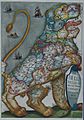
The Leo Belgicus is a special map that shows the old Low Countries (which are now mostly the Netherlands, Belgium, Luxembourg, and a small part of northern France). What makes this map unique is that it's drawn in the shape of a mighty lion!
The first Leo Belgicus map was made by an Austrian mapmaker named Michael Aitzinger in 1583. At that time, the Netherlands was in the middle of the Eighty Years' War, fighting for its freedom.
There were three main types of these lion-shaped maps. In the most common one, the lion's head was in the northeast part of the country, and its tail was in the southeast.
The most famous version of the Leo Belgicus was drawn by Claes Janszoon Visscher in 1609. This was an important year because it was when the Twelve Years' Truce began, which was a break in the fighting during the war.
A third version of the map was made later, after the Dutch Republic finally gained its freedom in 1648 with the Peace of Westphalia. This map is called the Leo Hollandicus, or the Holland Lion, and it only shows the province of Holland.
Images for kids
-
Bello Belgico by Stradæ, 1631

See also
 In Spanish: Leo Belgicus para niños
