Lindsay, Oklahoma facts for kids
Quick facts for kids
Lindsay, Oklahoma
|
|
|---|---|
| Motto(s):
"Working hard as a community"
|
|

Location of Lindsay, Oklahoma
|
|
| Country | United States |
| State | Oklahoma |
| County | Garvin |
| Area | |
| • Total | 2.32 sq mi (6.01 km2) |
| • Land | 2.32 sq mi (6.00 km2) |
| • Water | 0.01 sq mi (0.02 km2) |
| Elevation | 974 ft (297 m) |
| Population
(2020)
|
|
| • Total | 2,864 |
| • Density | 1,236.61/sq mi (477.46/km2) |
| Time zone | UTC-6 (Central (CST)) |
| • Summer (DST) | UTC-5 (CDT) |
| ZIP code |
73052
|
| Area code(s) | 405 |
| FIPS code | 40-43150 |
| GNIS feature ID | 2410840 |
Lindsay is a city in Garvin County, Oklahoma, United States. In 2020, about 2,864 people lived there. Lindsay used to be known as "The Broomcorn Capital of the World." This was because a special plant called broomcorn was grown a lot in the area. Today, broomcorn is no longer grown there, so the city doesn't use that slogan anymore.
Contents
History of Lindsay
Lindsay started in January 1902. Two big railroad companies, the Kiowa, Chickasha and Fort Smith Railway and the Chicago, Rock Island and Pacific Railroad, were building their train lines. They decided to connect their lines halfway between Chickasha and Pauls Valley. This connection was finished in 1903. Trains from Pauls Valley would stop and turn around in Lindsay. The same happened for trains from Chickasha.
The city of Lindsay was named after Lewis Lindsay. He was a farmer in the area. He gave 440 acres (about 1.8 square kilometers) of his land to create the town. When Lindsay was founded, it was part of Pickens County, Chickasaw Nation.
Geography of Lindsay
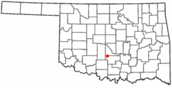
Lindsay is located in the northwest part of Garvin County. The northern edge of the town is right along the border of McClain County.
The city sits in the valley of the Washita River. Oklahoma State Highway 19 goes through the middle of Lindsay. This road is called Cherokee Street in town. If you go east on Highway 19, it's about 11 miles (18 km) to Maysville. If you go northwest, it's about 28 miles (45 km) to Chickasha. Oklahoma State Highway 76 also passes through Lindsay. It goes north about 23 miles (37 km) to Blanchard and south about 46 miles (74 km) to Healdton.
The total area of Lindsay is about 6.0 square kilometers (2.3 square miles). Most of this area is land. Only a tiny part, about 0.02 square kilometers (0.01 square miles), is water.
Climate in Lindsay
| Climate data for Lindsay, Oklahoma | |||||||||||||
|---|---|---|---|---|---|---|---|---|---|---|---|---|---|
| Month | Jan | Feb | Mar | Apr | May | Jun | Jul | Aug | Sep | Oct | Nov | Dec | Year |
| Mean daily maximum °F (°C) | 51.0 (10.6) |
56.6 (13.7) |
66.4 (19.1) |
75.8 (24.3) |
82.4 (28.0) |
89.4 (31.9) |
95.6 (35.3) |
95.1 (35.1) |
86.4 (30.2) |
76.8 (24.9) |
63.9 (17.7) |
53.6 (12.0) |
74.4 (23.6) |
| Mean daily minimum °F (°C) | 25.3 (−3.7) |
30.0 (−1.1) |
39.0 (3.9) |
49.1 (9.5) |
57.6 (14.2) |
65.5 (18.6) |
69.8 (21.0) |
68.1 (20.1) |
60.9 (16.1) |
49.9 (9.9) |
38.6 (3.7) |
28.8 (−1.8) |
48.6 (9.2) |
| Average precipitation inches (mm) | 1.3 (33) |
1.8 (46) |
2.9 (74) |
3.4 (86) |
5.4 (140) |
4.0 (100) |
2.1 (53) |
2.4 (61) |
4.3 (110) |
3.7 (94) |
2.2 (56) |
1.7 (43) |
35.1 (890) |
| Source 1: weather.com | |||||||||||||
| Source 2: Weatherbase.com | |||||||||||||
People in Lindsay
| Historical population | |||
|---|---|---|---|
| Census | Pop. | %± | |
| 1910 | 1,156 | — | |
| 1920 | 1,543 | 33.5% | |
| 1930 | 1,713 | 11.0% | |
| 1940 | 1,792 | 4.6% | |
| 1950 | 3,021 | 68.6% | |
| 1960 | 4,258 | 40.9% | |
| 1970 | 3,705 | −13.0% | |
| 1980 | 3,454 | −6.8% | |
| 1990 | 2,947 | −14.7% | |
| 2000 | 2,889 | −2.0% | |
| 2010 | 2,840 | −1.7% | |
| 2020 | 2,864 | 0.8% | |
| U.S. Decennial Census | |||
In 2000, there were 2,889 people living in Lindsay. They lived in 1,244 households, and 794 of these were families. The city had about 1,232 people per square mile (476 people per square kilometer).
Most people in Lindsay were White (about 90.86%). There were also many Native American people (about 4.92%). Other groups included African American, Asian, and Pacific Islander people. Some people were from other races or from two or more races. About 1.25% of the population was Hispanic or Latino.
About 27.3% of households had children under 18 living with them. About 52.1% were married couples. About 25% of the people in Lindsay were 65 years old or older. The average age was 40 years.
Economy of Lindsay
The main way people in Lindsay make money and find jobs is through the oilfield industry. This means that businesses related to finding and processing oil are very important here.
Education in Lindsay
Lindsay Public Schools provide education for students. They have schools for children from kindergarten all the way through high school.
Transportation in Lindsay
Lindsay is located where two important state highways meet: Oklahoma State Highway 76 and Oklahoma State Highway 19. Just east of town, another highway, SH-59B, connects with SH-19. This road then leads to Oklahoma State Highway 59.
The city also has its own airport, called Lindsay Municipal Airport. It is located northeast of the town.
Parks and Attractions in Lindsay
Lindsay has three public parks where people can relax and play:
- Charlie Jones Park is on North West 4th Street.
- George Brown Park is on Highway 76 North. The Lindsay Municipal Golf Course is also located here.
- Shady Grove Park is at 498 W Apache St. This park also has a swimming pool.
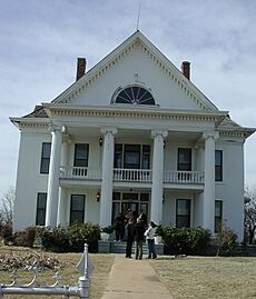
A special place to visit is the Murray-Lindsay Mansion & Pikes Peak School. The mansion was built in 1880 by Frank Murray, an immigrant from Ireland, and his wife, Alzira McCaughey, who was a Choctaw Indian. It has 15 rooms, two bathrooms, and four fireplaces. You can see how people lived back then, as it still has its original furniture. Across the road from the mansion is the Pikes Peak School House. This two-room school was built in 1908. The mansion is listed on the National Register of Historic Places listings in Garvin County, Oklahoma and is also known as "Erin Springs Mansion."
See also
 In Spanish: Lindsay (Oklahoma) para niños


