
Liri facts for kids
Quick facts for kids Liri |
|
| River | |
| Country | Italy |
|---|---|
| Regions | Abruzzo, Lazio |
| Provinces | L'Aquila, Frosinone |
| Comuni | Cappadocia, Sora, Isola del Liri, Ceprano, Aquino, Sant'Apollinare |
| Tributaries | |
| - left | Fibreno, Melfa |
| - right | Sacco |
| Small cities | Sora, Pontecorvo |
| Source | Monte Camiciola, Monti Simbruini |
| - location | Cappadocia, L'Aquila, Abruzzo, Italy |
| - elevation | 1,108 m (3,635 ft) |
| - coordinates | 42°00′10″N 13°16′59″E / 42.00278°N 13.28306°E |
| Confluence | Garigliano |
| - location | Sant'Apollinare, Frosinone, Lazio, Italy |
| - elevation | 15 m (49 ft) |
| - coordinates | 41°24′35″N 13°51′46″E / 41.40972°N 13.86278°E |
| Length | 120 km (75 mi) |
| Basin | 4,140 km² (1,598 sq mi) |
| Discharge | for Pontecorvo |
| - average | 50 m³/s (1,766 cu ft/s) |
The Liri River is an important river in central Italy. It flows through the Abruzzo and Lazio regions. When it reaches the Tyrrhenian Sea, it changes its name to Garigliano.
Contents
Journey of the Liri River
The Liri River is about 120 km (75 mi) long. If you include the Garigliano part, it stretches for 158 km (98 mi). The area of land that drains into the Liri is about 4,140 km2 (1,598 sq mi). The entire Liri-Garigliano river system drains an even larger area of 5,020 square kilometres (1,940 sq mi).
Where the River Starts
The Liri River begins high up on Monte Camiciola. This mountain is part of the Monti Simbruini, which are in the central Apennines mountain range. The river starts at a height of about 1,108 m (3,635 ft). This spot is in the town of Cappadocia, in the L'Aquila province, Abruzzo region.
The River's Path
The Liri first flows southeast through a long valley. This valley runs in the same direction as the Apennines mountains. The river continues until it reaches the city of Sora.
Before reaching Isola del Liri (which means "Liri Island"), another river called the Fibreno joins the Liri. After this, the Liri splits into two parts. These two parts then come back together, surrounding the lower part of the town. One of these branches even forms a 28-metre (92 ft) high waterfall!
A dam is built on the river after it meets the Sacco river. The Sacco is the Liri's biggest tributary (a smaller river that flows into a larger one). This happens near the town of Ceprano. The last major river to join the Liri is the Melfa, which meets it near Aquino.
The Liri River then forms the border between the Lazio and Campania regions. After passing Cassino, it joins with the Gari river. From this point on, the river is known as the Garigliano. After flowing for another 38 km (24 mi), the river finally empties into the Tyrrhenian Sea.
Towns and Provinces Along the Liri
The Liri River flows through two regions and two provinces in Italy. Here are some of the towns (called comuni) it passes through:
- Abruzzo region
- L'Aquila: Cappadocia, Castellafiume, Capistrello, Civitella Roveto, Canistro, Civita d'Antino, Morino, San Vincenzo Valle Roveto, Balsorano
- Lazio region
- Frosinone: Sora, Isola del Liri, Monte San Giovanni Campano, Fontana Liri, Arce, Strangolagalli, Ceprano, San Giovanni Incarico, Aquino, Pontecorvo, San Giorgio a Liri, Sant'Apollinare
Main Rivers Joining the Liri
Here are the most important rivers that flow into the Liri River:
|
Rivers joining from the left:
|
Rivers joining from the right:
|
Gallery
-
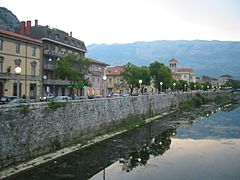
The Liri River in Sora.
-
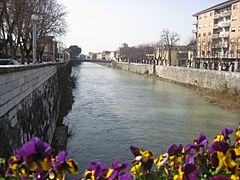
Another view of the Liri in Sora.
-
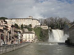
A beautiful waterfall in Isola del Liri.
-
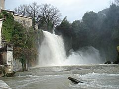
The Cascata Grande (Great Waterfall) in Isola del Liri.
-
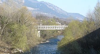
A Bridge crossing over the Liri River.


Related pages
See also
 In Spanish: Río Liri para niños
