
Province of Frosinone facts for kids
Quick facts for kids
Province of Frosinone
|
|
|---|---|

Palazzo Gramsci, province headquarters.
|
|

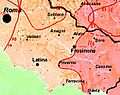
Map with the province of Frosinone, in red, in Italy
|
|
| Country | |
| Region | Lazio |
| Capital | Frosinone |
| Comuni | 91 |
| Area | |
| • Total | 3,247.08 km2 (1,253.70 sq mi) |
| Population
(January 2017)
|
|
| • Total | 493,067 |
| • Density | 151.8494/km2 (393.2880/sq mi) |
| Time zone | UTC+1 (CET) |
| • Summer (DST) | UTC+2 (CEST) |
| Postal code |
03100
|
| Telephone prefix | 0775 |
| Vehicle registration | FR |
| ISTAT | 060 |
| Website | Official website: http://www.provincia.fr.it/ |
The Province of Frosinone (called Provincia di Frosinone in Italian) is a special area in the Lazio region of Central Italy. Its main city, or capital, is Frosinone.
Contents
History of Frosinone Province
The Province of Frosinone was created in December 1926. It was formed using parts of the Lazio and Campania regions.
Geography and Nature
.svg)
The Province of Frosinone covers an area of about 3,247 square kilometers (1,254 square miles). This makes it the third largest province in the Lazio region.
This province is located in the southeast part of the Lazio region. It shares borders with several other areas:
- To the north, it borders the Abruzzo region (specifically the L'Aquila province).
- To the northwest and west, it borders the Metropolitan City of Rome.
- To the east, it borders the Molise region (the Isernia province).
- To the southeast, it borders the Campania region (the Caserta province).
- To the south, it borders the Latina province.
 |
Rome | L'Aquila province (Abruzzo) | |
|
| Rome | Isernia province (Molise) | |||
| Latina province | Caserta province (Campania) |
The highest mountain in the province is called Monte Meta, or simply La Meta. It is about 2,242 meters (7,356 feet) tall. This mountain is located right on the border with the L'Aquila province.
The two most important rivers in the province are the Liri and its branch, the Sacco river. The Liri river is about 120 kilometers (75 miles) long, and the Sacco river is about 87 kilometers (54 miles) long.
Population in Frosinone Province
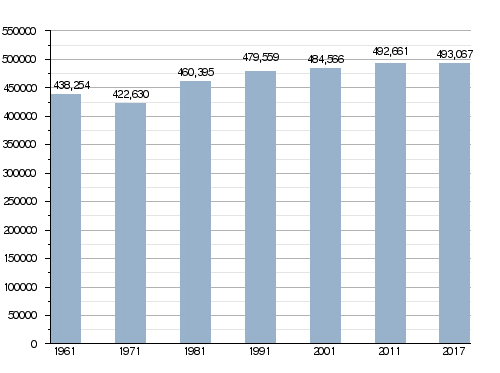
In 2017, there were 493,067 people living in the Province of Frosinone. This means there were about 151.8 people living in each square kilometer.
How the population has changed in Frosinone province
How the Province is Run

The Province of Frosinone is made up of 91 smaller towns or areas called comuni (singular: comune). These comuni are:
- Acquafondata
- Acuto
- Alatri
- Alvito
- Amaseno
- Anagni
- Aquino
- Arce
- Arnara
- Arpino
- Atina
- Ausonia
- Belmonte Castello
- Boville Ernica
- Broccostella
- Campoli Appennino
- Casalattico
- Casalvieri
- Cassino
- Castelliri
- Castelnuovo Parano
- Castro dei Volsci
- Castrocielo
- Ceccano
- Ceprano
- Cervaro
- Colfelice
- Colle San Magno
- Collepardo
- Coreno Ausonio
- Esperia
- Falvaterra
- Ferentino
- Filettino
- Fiuggi
- Fontana Liri
- Fontechiari
- Frosinone
- Fumone
- Gallinaro
- Giuliano di Roma
- Guarcino
- Isola del Liri
- Monte San Giovanni Campano
- Morolo
- Paliano
- Pastena
- Patrica
- Pescosolido
- Picinisco
- Pico
- Piedimonte San Germano
- Piglio
- Pignataro Interamna
- Pofi
- Pontecorvo
- Posta Fibreno
- Ripi
- Rocca d'Arce
- Roccasecca
- San Biagio Saracinisco
- San Donato Val di Comino
- San Giorgio a Liri
- San Giovanni Incarico
- San Vittore del Lazio
- Sant'Ambrogio sul Garigliano
- Sant'Andrea del Garigliano
- Sant'Apollinare
- Sant'Elia Fiumerapido
- Santopadre
- Serrone
- Settefrati
- Sgurgola
- Sora
- Strangolagalli
- Supino
- Terelle
- Torre Cajetani
- Torrice
- Trevi nel Lazio
- Trivigliano
- Vallecorsa
- Vallemaio
- Vallerotonda
- Veroli
- Vicalvi
- Vico nel Lazio
- Villa Latina
- Villa Santa Lucia
- Villa Santo Stefano
- Viticuso
The largest comune by area is Veroli, covering about 119.65 square kilometers (46.19 square miles). The smallest is Vicalvi, which is about 8.21 square kilometers (3.17 square miles). The comune with the fewest people living in it is Acquafondata, with only 263 inhabitants.
Largest Comuni by Population
Here are the 10 comuni with the most people living in them, along with their population, size, and height above sea level.
| No. | Comune | Population (2017) |
Area (km²) |
Density | Altitude (m) |
|---|---|---|---|---|---|
| 1 | Frosinone | 46,120 | 46.85 | 984.4 | 291 |
| 2 | Cassino | 36,460 | 83.42 | 437.1 | 40 |
| 3 | Alatri | 28,884 | 96.96 | 297.9 | 502 |
| 4 | Sora | 26,057 | 72.13 | 361.3 | 300 |
| 5 | Ceccano | 23,494 | 61.06 | 384.8 | 200 |
| 6 | Anagni | 21,411 | 112.82 | 189.8 | 424 |
| 7 | Ferentino | 21,131 | 81.00 | 260.9 | 395 |
| 8 | Veroli | 20,525 | 119.65 | 171.5 | 615 |
| 9 | Pontecorvo | 13,200 | 88.80 | 148.6 | 97 |
| 10 | Monte San Giovanni Campano | 12,847 | 48.71 | 263.7 | 438 |
Gallery of Frosinone Province
-
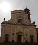
The cathedral in Frosinone.
-
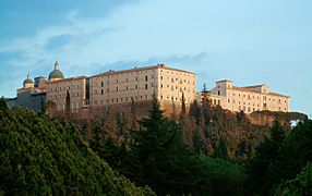
The Monte Cassino Abbey.
-
The Palazzo di Bonifacio VIII in Anagni.
-
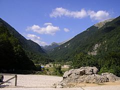
The Canneto valley.


.jpg)

More to Explore
- List of communes of the Province of Frosinone
Images for kids
-
A map showing the different languages spoken in Southern Lazio. Pink shows Central Italian, and magenta shows Southern Italian (Neapolitan dialects).

See also
 In Spanish: Provincia de Frosinone para niños
