
List of New York State Historic Markers in Richmond County, New York facts for kids
Have you ever seen a special sign, often blue or green, that tells you about something important that happened a long time ago? These are called historic markers! New York State has placed many of these markers all over, including in Richmond County, which is also known as Staten Island. These markers help us learn about the exciting history of this area, from old battles to the first settlements and important meetings.
Contents
Exploring Richmond County's History
Richmond County, or Staten Island, has a rich past. These historic markers point out places where big events happened. They help us imagine what life was like hundreds of years ago.
Important Historic Markers
Here are some of the special historic markers you can find in Richmond County:
Battle Hill
This marker tells us about a place called Battle Hill. It was once an Indian village. In 1643, the Dutch attacked this village. Later, during the Revolutionary War, the British built a small fort here. You can find this marker on the corner of Western and Washington Avenue in Richmond, New York.
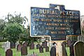
Burial Place
This marker shows where the early Dutch settlers of the North Shore were buried. This burial ground was used until 1696. The area around it eventually grew into the community of Port Richmond. The marker is on Richmond Avenue, between the railroad and Richmond Terrace in Port Richmond, New York.
Conference House
The Conference House is a very important historical spot. On September 11, 1776, famous American leaders like Benjamin Franklin and John Adams met here. They talked with British representatives, including Lord Howe and Sir Henry Strachey. They were trying to find a peaceful way to end the Revolutionary War. The marker is about 100 feet from Phillip Street, near Craig Avenue and Hylan Boulevard in Tottenville, Staten Island.
French Church
This marker points to where the first church on Staten Island once stood. It was a French church built in 1695. At that time, it was the only church on the island. The marker is on Arthur Kill Road, between Gifford's land and Richmond Avenue in Richmond, New York.
Old Town
Old Town was the first permanent settlement on Staten Island. It was started in 1661 by Pierre Billiou and others. They received permission from the Dutch West India Company to settle here. The marker is on the corner of Old Town Road in Old Town, Staten Island.
English Church
This marker shows the spot where an English Church (which was Presbyterian) stood. It was here from 1729 to 1769. The marker is on Richmond Road in Richmond, New York.
Perine House
The land where the Perine House stands was first given to Thom. Stillwell in September 1677. Before that, it was covered by Dutch land grants to Pierre Billiou and Han Christofel. The marker is on Richmond Road in Richmond, New York.
Signal Hill
Signal Hill was used as a special signal station. It was part of a military area near Bay Street. The forts here were rebuilt in 1812. The marker is near Bay Street in Richmond, New York.
Site of Fort Knyphausen
This marker shows the location of Fort Knyphausen. This fort was used by the British during the Revolutionary War. The marker is on Daniel Low Terrace, between Fort Place and Low Circle in Richmond, New York.
The Christopher House
The Christopher House was built around 1750. It was a home where local patriots from Staten Island traditionally met during the Revolutionary War. The marker is about 200 feet from Willow Brook Road and Victory Building in Richmond, New York.
Images for kids
-
The burial place of early Dutch settlers in Port Richmond.

See also
