List of rivers and water bodies of Montreal Island facts for kids
The rivers and water bodies of Montreal are mostly man-made today. For a long time, the natural water system of the island of Montreal stayed the same. But around the 1800s, Montreal started big building projects. These included creating the Lachine Canal and many of the city's first large parks.
Contents
History of Montreal's Waterways
After the Ice Age
About 13,000 years ago, after the last Ice Age, a huge body of water called the Champlain sea covered Montreal. It also covered the area known as the Saint Lawrence Lowlands. Over a few hundred years, this sea slowly dried up. As the water went away, Mount Royal and its three peaks appeared as islands.
When the sea was completely gone, some water stayed behind in low areas on the island. One example was Beaver Lake, located right on Mount Royal. This lake slowly turned into a swampy area. In 1938, it was dug out again to become the lake we see today.
Montreal's Old Rivers and Lakes

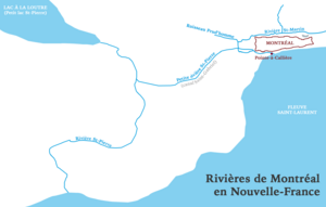
Long ago, Montreal had a complex system of rivers and lakes. Most of these are now gone or flow through underground pipes.
- Otter Lake: This was a marshy lake, about 4 kilometers long and 1 kilometer wide. It was located halfway between Old Montreal and Lachine. Over time, it was filled in and dried up. This happened especially when the Lachine Canal was built and industries grew in the area. Today, Highway 20 runs right through where the lake used to be.
- Saint Pierre River: This river started in Côte-des-Neiges and flowed down to Notre-Dame-de-Grâce. It widened to form Otter Lake. After the lake, it continued towards the St. Lawrence River, ending near Nuns' Island.
- Little St. Pierre River: This river was created by people in 1697 and called "St. Gabriel canal." It connected the Saint-Pierre River (east of Otter Lake) to the Pointe-à-Callière Museum area. Part of it was turned into an underground sewer pipe in 1832. The Pointe-à-Callière Museum plans to show parts of this old river to the public around 2017.
- Saint Martin River: Also known as "Little River," this river began near Mount Royal Cemetery. It flowed through Outremont, Quebec, Mile End, and the Plateau Mont-Royal area. It even went through La Fontaine Park, where the park's pond is a small part of the old river. From there, it branched west, running along the old fortifications of Montreal to the main river. You can still find some small signs of this river today.
Waterways Today
Today, Montreal has only a few natural streams and lakes left. However, many parks have large ponds or artificial lakes that were built by people.
List of Montreal's Water Bodies
Here is a partial list of the current water bodies on the island of Montreal:
| Name | Photo | Location | Location details | Type | Area (ha) |
|---|---|---|---|---|---|
| Lachine Canal |  |
Montreal | 45°27′39″N 73°36′17″W / 45.4607°N 73.6046°W | artificial | 158 hectares (390 acres) |
| Aqueduct Canal |  |
Montreal | 45°26′11″N 73°35′58″W / 45.4363°N 73.5994°W | artificial | [convert: needs a number] |
| Olympic pool |  |
Jean-Drapeau Park | 45°30′32″N 73°31′26″W / 45.5089°N 73.5238°W | artificial | 24 hectares (59 acres) |
| Lake Île Notre-Dame |  |
Jean-Drapeau Park | 45°30′08″N 73°31′31″W / 45.5023°N 73.5253°W | artificial | 14 hectares (35 acres) |
| Centennial Lake |  |
Dollard-Des Ormeaux | 45°29′12″N 73°48′51″W / 45.4868°N 73.8143°W | artificial | 9.8 hectares (24 acres) |
| Lac des Dauphins |  |
Jean-Drapeau Park | 45°31′27″N 73°32′11″W / 45.5241°N 73.5364°W | artificial | 5 hectares (12 acres) |
| Lac des Battures |  |
Nuns' Island | 45°27′16″N 73°33′17″W / 45.4545°N 73.5546°W | artificial | 5 hectares (12 acres) |
| Main pond Parc Angrignon |  |
Angrignon Park | 45°26′35″N 73°36′05″W / 45.4430°N 73.6014°W | artificial | 4.8 hectares (12 acres) |
| Little Basin |  |
Parc des Rapides | 45°25′40″N 73°35′29″W / 45.4278°N 73.5914°W | artificial | 3.5 hectares (8.6 acres) |
| Swan Lake |  |
Jean-Drapeau Park | 45°30′31″N 73°32′04″W / 45.5087°N 73.5344°W | artificial | 3 hectares (7.4 acres) |
| Pond Fountain |  |
Parc La Fontaine | 45°31′29″N 73°34′09″W / 45.5248°N 73.5691°W | artificial | 2.8 hectares (6.9 acres) |
| Beaver Lake |  |
Mount Royal Park | 45°29′55″N 73°35′51″W / 45.4986°N 73.5974°W | artificial | 1.9 hectares (4.7 acres) |
| Basin Jarry Park |  |
Jarry Park | 45°32′07″N 73°37′30″W / 45.5353°N 73.6249°W | artificial | 1 hectare (2.5 acres) |
List of Rivers
- Rivière à l'Orme
- Bertrand Brook
- Saint-Pierre River (Montreal)
- Lachine Canal
- Aqueduct Canal
- St. Lawrence River
- Prairie River (Montreal)
See also
- Blue Network of Montreal
- List of rivers of Quebec
- List of canals of Quebec
 | Jessica Watkins |
 | Robert Henry Lawrence Jr. |
 | Mae Jemison |
 | Sian Proctor |
 | Guion Bluford |

