Little Blackfoot River facts for kids
Quick facts for kids Little Blackfoot River |
|
|---|---|

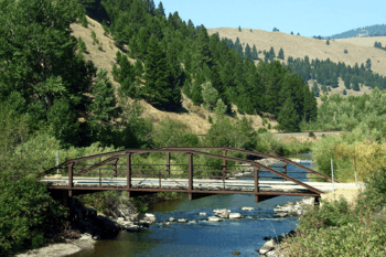
The Little Blackfoot River Bridge at Avon, Montana.
|
|
|
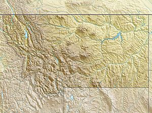
Location of the headwaters of the Little Blackfoot River in Powell County, Montana
|
|
| Country | United States |
| State | Montana |
| County | Powell County |
| Physical characteristics | |
| Main source | West side of the Continental Divide in southeastern Powell County, Montana 7,476.5 ft (2,278.8 m) 46°21′46″N 112°29′31″W / 46.36278°N 112.49194°W |
| River mouth | Clark Fork River Powell County, Montana 4,243 ft (1,293 m) 46°21′46″N 112°29′31″W / 46.36278°N 112.49194°W |
| Length | 48 mi (77 km) |
| Basin features | |
| Basin size | 413 sq mi (1,070 km2) |
The Little Blackfoot River is a river in Montana, United States. It flows for about 48-mile (77 km) (77 km) through Powell County, Montana. This river is a tributary of the larger Clark Fork River.
Contents
Where the River Flows
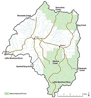
The Little Blackfoot River is found in Powell County, Montana. It's about 48-mile (77 km) long. The area of land that drains into the river, called its watershed, covers 413 square miles (1,070 km2) (1,070 km²). The river got its name from the Piegan Blackfeet tribe. They often visited this area long ago. The name was first written down in 1831 by a trader named John Work.
The river starts high up on the west side of the Continental Divide. This is a line of mountains that separates rivers flowing to the Pacific Ocean from those flowing to the Atlantic. The river begins near Thunderbolt Mountain in the Boulder Mountains. Long, long ago, before the last Ice Age, a glacier on Thunderbolt Mountain helped shape the valley where the river flows. This glacier was very big, about 24 to 25 miles (39 to 40 km) (39 to 40 km) long!
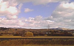
The Little Blackfoot River eventually flows into the Clark Fork River near Garrison, Montana. For most of its journey, the river winds through thick forests in the mountains. Some parts of its watershed are open mountain valleys. A small portion is used for farming, especially for growing hay. Just over half of the land in the river's watershed is privately owned.
The amount of rain and snow in the Little Blackfoot River watershed changes a lot. Valleys might get 10 to 20 inches (25 to 51 cm) (25 to 51 cm) of precipitation. The mountains can get much more, from 30 to 50 inches (76 to 127 cm) (76 to 127 cm). The river's water flow also changes throughout the year. It's usually highest in May because of melting snow and spring rains. The lowest water levels are in September.
There are only a few small towns along the river. These include Elliston and Avon, Montana. Most of the area is made up of scattered ranches and rural homes. U.S. Route 12 runs alongside the river for much of its length.
How People Use the River's Water
The main way people use the Little Blackfoot River is for irrigation. This means they use the water to grow hay on ranches. The hay is then fed to cattle. Many people have rights to use water from the river. We don't know exactly how much water is taken each year.
In the past, mining was very common in the Elliston area. This happened from the 1860s until the late 1900s. Mining activities have had some negative effects on the river. There are many old, abandoned mines in the river's watershed. Some of these mines could still impact the river's health.
Logging, which is cutting down trees, also happened in the 1970s and 1980s. However, it's not a major activity in the area anymore.
River Health and Pollution
Some parts of the Little Blackfoot River and its smaller streams are affected by pollution. This means they might not be able to fully support fish and other aquatic life. For example, the upper part of the river can only partly support fish. However, it's generally safe for farming, drinking water, and recreation. The lower part of the river is a bit more polluted. It also only partly supports fish, and people should be careful if using it for drinking or swimming. It is safe for farming and industry.
Several things can pollute the river. Chemicals like nitrate and nitrite are a concern in the lower river. These often come from ranching, hay farming, and cattle grazing. Toxic metals were also found in the river starting in 1990. In the upper river, metals like cadmium, copper, and lead were found in amounts that could harm aquatic life. Some levels of arsenic and lead were also too high for human drinking water. In the lower river, lead and arsenic were also found in amounts that were too high.
Fish and Wildlife in the River
The Little Blackfoot River has a fairly healthy population of fish. You can find fish like mottled sculpin, mountain whitefish, slimy sculpin, westslope cutthroat trout, brook trout, brown trout, and rainbow trout. The brook, brown, and rainbow trout were brought to the river by people.
Even though the river has many fish, the westslope cutthroat trout are a "species of concern." This means their numbers are going down, and they are losing their natural homes. Another fish, the bull trout, used to live here but is now gone from the watershed.
One of the biggest problems for fish in the river is too much sediment and silt. This is like fine dirt and sand that washes into the river. When cattle graze too much along the riverbanks, it can remove plants that hold the soil in place. This leads to more dirt washing into the river. This makes the river shallower and removes deep pools where fish like to live. Some old mining activities also made parts of the river wider and shallower.
Some parts of the river are in great shape for wildlife. Other parts have problems because of less plant life, erosion, and human changes to the riverbanks. The United States Environmental Protection Agency has said that the Little Blackfoot River adds a lot of sediment to the Clark Fork River.
Historical Importance
An explorer and U.S. Army lieutenant named John Mullan discovered "Hell Gate Pass" on September 24, 1853. This mountain pass is near where the Little Blackfoot River begins. In March 1854, Mullan also found Mullan Pass, which is another important mountain pass nearby.
The Little Blackfoot River Bridge in Avon, Montana, is a special historical site. It's part of "Montana's Historic Steel Truss Bridges," which are listed on the National Register of Historic Places. This bridge was built in 1914 for $2,540. It is 61 feet (19 m) (19 m) long and 16 feet (4.9 m) (4.9 m) wide. The bridge is a unique type called a pin-connected camelback Pratt truss steel bridge. This kind of bridge is very rare, and this is the only one like it in Montana.
 | Aurelia Browder |
 | Nannie Helen Burroughs |
 | Michelle Alexander |


