Little Venice Island facts for kids

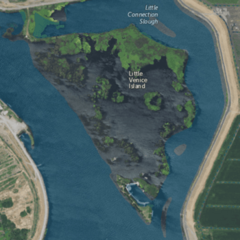
USGS aerial imagery of Little Venice Island, with Medford Island to the west, Empire Tract to the east, and a bridge connecting to Venice Island on the northwest.
|
|
| Geography | |
|---|---|
| Location | Northern California |
| Coordinates | 38°03′02″N 121°30′05″W / 38.05056°N 121.50139°W |
| Adjacent bodies of water | Sacramento–San Joaquin River Delta |
| Highest elevation | 0 ft (0 m) |
| Administration | |
|
United States
|
|
| State | |
| County | San Joaquin |
Little Venice Island is a small piece of land located in the Sacramento–San Joaquin River Delta in California. It's part of San Joaquin County, which is in the northern part of California. This island is known for being very flat, with an elevation of 0 feet (or 0 meters) above sea level. This measurement was taken by the United States Geological Survey (USGS) in 1981.
Contents
Discover Little Venice Island
Little Venice Island might be small, but it's an interesting part of California's geography. It's one of many islands found in the large delta region where two major rivers meet.
Where is Little Venice Island Located?
Little Venice Island is found in the heart of the Sacramento–San Joaquin River Delta. This delta is a huge area where the Sacramento River and the San Joaquin River flow together before reaching San Francisco Bay. It's a mix of waterways, islands, and wetlands.
- Part of San Joaquin County: The island belongs to San Joaquin County, which is in the central part of California's Central Valley.
- Coordinates: You can find Little Venice Island on a map using its coordinates: 38°03′02″N 121°30′05″W / 38.05056°N 121.50139°W. These numbers help pinpoint its exact spot on Earth.
What is the Sacramento–San Joaquin River Delta?
The Sacramento–San Joaquin River Delta is a very important natural area in California. It's like a giant network of rivers, channels, and islands.
- Water Supply: This delta is a key source of water for millions of people and farms across California.
- Wildlife Habitat: It's also home to many different kinds of plants and animals, including fish, birds, and other wildlife.
- Island Formation: Many of the islands in the delta, like Little Venice Island, were formed over time by sediment (like mud and sand) carried by the rivers.
How High is Little Venice Island?
One unique fact about Little Venice Island is its elevation.
- Sea Level: In 1981, the United States Geological Survey (USGS) measured the island's elevation as 0 feet (which is the same as 0 meters). This means the island is right at the same level as the sea.
- USGS Role: The USGS is a science agency in the United States. They study the Earth, its natural resources, and natural hazards. Measuring elevations is one of the many things they do to help us understand our planet.
 | Percy Lavon Julian |
 | Katherine Johnson |
 | George Washington Carver |
 | Annie Easley |


