Locke Island

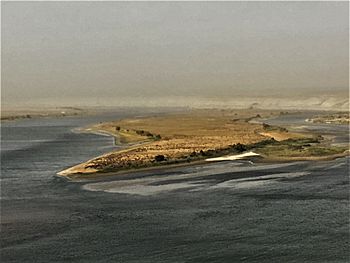
The southern tip of Locke Island seen from the White Bluffs
|
|
|
Locke Island in Washington
|
|
| Geography | |
|---|---|
| Location | Columbia River, Hanford Reach National Monument, Washington |
| Coordinates | 46°42′19″N 119°28′03″W / 46.70528°N 119.46750°W |
| Highest elevation | 397 ft (121 m) |
| Administration | |
|
United States
|
|
| State | Washington |
| County | Grant County |
Locke Island is an island in the Columbia River in Washington, United States. It's part of the Hanford Reach National Monument. This monument was created from lands around the Hanford Site.
Locke Island is a very important archeological site. It is even listed on the National Register of Historic Places. Sadly, the island's history is being threatened. A landslide has changed the river's path. This causes the island to erode, or wear away, quickly.
Contents
Island History
People have used Locke Island in many different ways over time. Long ago, Native Americans used the island. They fished and did other river activities there. Later, American settlers moved into the area. They started farming near the Columbia River. A town called White Bluffs grew up nearby.
However, the town of White Bluffs was later abandoned. This happened when the Hanford Site was built. The Hanford Site was a secret project. It was part of the Manhattan Project during World War II.
Native American Life on the Island
Locke Island is close to old Native American fishing spots. Tribes like the Yakama, Nez Perce, and ancestors of the Wanapum used these areas. Two main fishing spots were called Tah-Koot and Wy-Yow-Na. Many people camped right on Locke Island. Others traveled from places like Idaho to trade goods.
Usually, only members of the local tribes fished here. One Native American told researchers that families would catch about 300 fish. This was during their time fishing in the area. People even held celebrations at the campsites until about 1904.
Many old tools and items have been found on the island. These show that people lived there for a very long time. In 1996–1997, erosion uncovered items buried deep in the ground. These items showed people were there as early as 2,000 years ago. Other items found are from the 1800s. You can find many obsidian cutting tools and arrowheads on the island.
The Native American lands were given to the United States in 1855. This happened at the Walla Walla Council. The Umatilla and Yakama Tribes signed a treaty there.
Why People Left the Island
As more settlers came to the Columbia Basin, Native Americans used Locke Island less. The new settlers changed the river's environment. They caught too many fish and built dams. No roads or buildings were ever built on the island itself. But people did farm and raise animals nearby. This was especially true on the Benton County side of the river. The town of White Bluffs was only a few miles south.
Locke Island became part of a special protected area in the 1940s. This happened when the Hanford Site was built. The government needed a large, secret area for the project. People living there had to move away. The Hanford Site was used to make parts for nuclear weapons. A big security zone was created around it. Locke Island was inside this zone.
Because of this, Locke Island remained untouched. In 2000, much of this security zone became the Hanford Reach National Monument. Locke Island is still part of this monument. It remains closed to the public today.
Island Geology
Locke Island is made of alluvium. This is sand, silt, and clay left by the Columbia River. It has been building up since the Pleistocene Ice Age. Underneath this material are older rocks called the Columbia River Basalt Group. Much of the island's material comes from the Ringold Formation. This formation was laid down by the Columbia River millions of years ago. The White Bluffs are cliffs right next to the island. They were formed by this same erosion.
The White Bluffs have become unstable. Water from the Columbia Basin Irrigation Project flows into the ground. This water makes the cliffs weak. Parts of the cliff have slid into the river. A large slide happened right at Locke Island. This slide has made the eastern side of the river narrower. This causes the river to flow faster around the island. It also increases erosion on the island's middle section.
Since 1996, up to 40 meters (130 ft) of the island's eastern side has been washed away. The landslide started moving in the 1970s. But it has not moved much since 1998. This erosion is a big problem. It threatens the old Native American items on the island. It also harms salmon spawning sites downstream.
Island Ecology
Locke Island is in a shrub-steppe area. This means it's a dry grassland with shrubs. It's in the rain shadow of the Cascade Range. So, it gets little rain and has very hot or cold temperatures.
This area was once an important place for salmon. But by 1999, no salmon were seen spawning around the island. Still, about 81% of the area seems good for salmon to lay their eggs.
Canadian geese used to be very common on Locke Island. In 1957, 129 goose nests were counted there. But Coyotes have reduced the goose population. For many decades, fewer than ten successful nests have been found each year. The coyotes on Locke Island are special. Unlike other islands in the Hanford Reach, coyotes actually live on Locke Island. They don't just visit. The island is also home to deer and eagles.
The plants on the island are similar to other parts of Eastern Washington. You'll mostly find native grasses and short shrubs like sagebrush. These plants provide homes for the animals. However, invasive species are a threat to this plant life.


