Los Alamos, California facts for kids
Quick facts for kids
Los Alamos
|
|
|---|---|

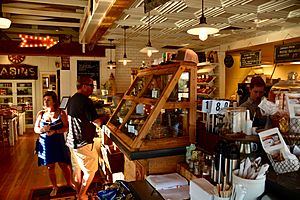
Bob’s Well Bread Bakery, Los Alamos
|
|

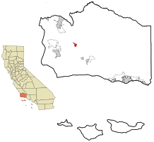
Location in Santa Barbara County and the state of California
|
|
| Country | United States |
| State | California |
| County | Santa Barbara |
| Area | |
| • Total | 3.869 sq mi (10.019 km2) |
| • Land | 3.868 sq mi (10.018 km2) |
| • Water | 0.001 sq mi (0.002 km2) 0.02% |
| Elevation | 568 ft (174 m) |
| Population
(2020)
|
|
| • Total | 1,839 |
| • Density | 475.32/sq mi (183.55/km2) |
| Time zone | UTC-8 (Pacific) |
| • Summer (DST) | UTC-7 (PDT) |
| ZIP code |
93440
|
| Area code | 805 |
| FIPS code | 06-43252 |
| GNIS feature IDs | 245130, 2408131 |
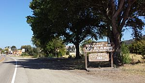
Los Alamos (which means The Cottonwoods in Spanish) is a small community in Santa Barbara County, California, United States. It's not an official city, but a "community" and a "CDP" (which means the government counts its population for statistics).
Los Alamos is located in the Los Alamos Valley. It's considered part of the Santa Ynez Valley area. The town is connected to other places like Vandenberg SFB, Lompoc, Buellton, and Solvang. It is about 140 miles (225 km) northwest of Los Angeles. In 2020, about 1,839 people lived there.
Contents
History of Los Alamos
The land where Los Alamos sits was once part of a large Mexican land grant called Rancho Los Alamos. This was given to José Antonio de la Guerra in 1839. Later, in 1876, three men named Thomas Bell, John S. Bell, and Dr. James B. Shaw bought parts of this land. They decided to create the town of Los Alamos. They even made "Centennial Street" the main road, celebrating 100 years of the U.S.
Los Alamos quickly became a busy stop for stagecoaches from 1861 to 1901. The famous Union Hotel opened in 1880 to welcome travelers. A narrow-gauge train, the Pacific Coast Railway, also ran through Los Alamos from 1882 to 1940. This helped the town grow.
Later, oil was found nearby in 1901 and 1903, which brought more money and jobs to the area. Today, Los Alamos is special because it has the last standing Pacific Coast Railroad Station. You can also find many wine tasting rooms, nice restaurants, and antique shops there. People still pick up their mail from the Post Office downtown, as there is no street delivery.
Geography and Climate
Los Alamos covers about 3.9 square miles (10.1 square kilometers) of land. It's located in the middle of Santa Barbara's wine country, right off U.S. Route 101. The town is in a narrow valley, surrounded by gentle rolling hills.
It's about 10 miles (16 km) north of Buellton and 15 miles (24 km) south of Santa Maria. Los Alamos is somewhat isolated, meaning it's a bit of a drive to bigger cities. San Antonio Creek flows through the town on its way to the ocean.
Weather in Los Alamos
Los Alamos has a "warm-summer Mediterranean climate." This means it has warm, dry summers and mild, wet winters. The average monthly temperatures in summer are not extremely hot, usually below 83°F (28°C).
| Climate data for Los Alamos, California | |||||||||||||
|---|---|---|---|---|---|---|---|---|---|---|---|---|---|
| Month | Jan | Feb | Mar | Apr | May | Jun | Jul | Aug | Sep | Oct | Nov | Dec | Year |
| Mean daily maximum °C (°F) | 64 (18) |
64 (18) |
68 (20) |
71 (22) |
76 (24) |
78 (26) |
81 (27) |
83 (28) |
82 (28) |
78 (26) |
70 (21) |
65 (18) |
73 (23) |
| Mean daily minimum °C (°F) | 38 (3) |
39 (4) |
40 (4) |
41 (5) |
46 (8) |
49 (9) |
52 (11) |
53 (12) |
51 (11) |
44 (7) |
41 (5) |
36 (2) |
44 (7) |
| Average precipitation mm (inches) | 3.2 (81) |
3.2 (81) |
2.8 (71) |
1.2 (30) |
0.3 (7.6) |
0.1 (2.5) |
0 (0) |
0 (0) |
0.2 (5.1) |
0.6 (15) |
1.4 (36) |
2.5 (64) |
15.5 (390) |
| Source: Weatherbase | |||||||||||||
People of Los Alamos
In 2010, Los Alamos had a population of 1,890 people. Most of the people living there were White (88.2 percent). About 40.9 percent of the population identified as Hispanic or Latino.
The population is spread out in terms of age. About 26.2 percent of the people were under 18 years old. The median age was about 38.2 years old. This means half the people were younger than 38.2 and half were older.
Most people in Los Alamos live in homes they own (61.5 percent), while others rent (38.5 percent).
Economy and Jobs
Los Alamos is a small town in an area known for its ranches, oil fields, and farms. Farmers grow vegetables like broccoli, lettuce, and strawberries. There are also many vineyards that grow grapes for wine.
The main street in Los Alamos is Bell Street, also known as California Route 135. This street is home to many local businesses, including restaurants and wineries. Some of these places have even been featured in magazines!
Parks and Fun Things to Do
Los Alamos has a couple of parks for people to enjoy. The local elementary school, Olga Reed School, is right next to Los Alamos County Park. Another park, Arthur Ferrini Park, is located near the Los Alamos Market. Many people in town like to walk or ride their bicycles around.
Arts and Culture
One of the biggest events in Los Alamos is "Los Alamos Old Days." This celebration happens every September on Bell Street. It usually lasts for two days and includes booths, stands, and a parade. The parade celebrates the history and farming traditions of the Los Alamos Valley, which is also known as the "Valley of the Cottonwoods." The name "álamo" in Spanish refers to the Fremont Cottonwood trees that are native to the area and used to grow along San Antonio Creek.
Los Alamos in Movies and Music
Los Alamos has been featured in popular culture:
- The town was shown in an episode of Visiting... with Huell Howser (Episode 1022).
- In the 2004 movie Sideways, one of the main characters, Stephanie, lives in Los Alamos.
- The famous Union Hotel in Los Alamos was used as a filming location for the music video "Say Say Say" by Michael Jackson and Paul McCartney.
See also
 In Spanish: Los Álamos (California) para niños


