Los Alerces National Park facts for kids
Quick facts for kids Los Alerces National Park |
|
|---|---|
| Parque Nacional Los Alerces | |
|
IUCN Category II (National Park)
|
|

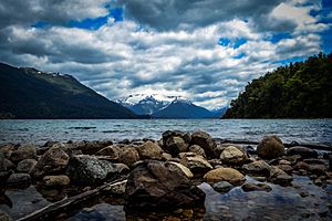
Lake Futalaufquen, one of the many lakes in the Los Alerces National Park.
|
|
| Lua error in Module:Location_map at line 420: attempt to index field 'wikibase' (a nil value). | |
| Location | Chubut Province, Argentina |
| Area | 2,599 km2 (1,003 sq mi) |
| Established | 1937 |
| Governing body | Administración de Parques Nacionales |
| Type: | Natural |
| Criteria: | vii, x |
| Designated: | 2017 (41st session) |
| Reference #: | 1526 |
| Region: | Latin America |
Los Alerces National Park (also known as Parque Nacional Los Alerces in Spanish) is a stunning natural area in Argentina. It is located in the Andes mountains, in the Chubut Province of the Patagonian region. The park's western edge touches the border with Chile.
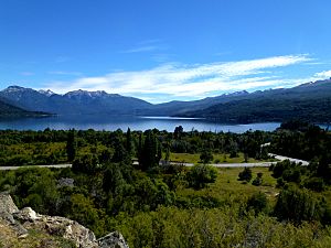
This park was shaped by ancient glaciers, which left behind amazing features like clear lakes and unique rock formations. It is covered in thick, cool forests. Higher up, near the rocky Andean peaks, you'll find open meadows.
A very special part of the park is its alerce forest. The alerce tree is one of the oldest living tree species in the world, with some living for over 3,600 years! These forests are very well-preserved. The park helps protect some of the last untouched Patagonian forests. It is also home to many rare plants and animals found nowhere else.
Contents
Discover the Ancient Alerce Trees
Los Alerces National Park became a World Heritage Site in 2017. It was created in 1937 to protect the alerce trees, which the Mapuche people call lahuán. The park also protects other plants found in the Patagonian Andes.
This park has the largest alerce forest in Argentina. Alerce trees can grow very tall and wide, much like the giant Sequoia trees in the United States. They are among the longest-living trees on Earth. Some alerce trees in Chile are over 3,600 years old!
Alerce trees grow very slowly. They belong to the cypress family. These trees are only found in a small area of Chile and Argentina. Sadly, they are an endangered species because people used to cut them down for wood.
Visiting the Oldest Alerce Trees
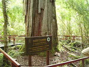
The most famous alerce forest in the park is easy to visit by boat. It is located at a spot called Puerto Sagrario, at the northern end of Lake Menéndez. Here, you can see the largest known alerce tree in Argentina.
This giant tree is about 57 meters (187 feet) tall and 2.2 meters (7.2 feet) wide. It is an incredible 2,600 years old! There are regular tours that take visitors to see this amazing forest. Even taller alerce trees might exist in other parts of Lake Menéndez, but those areas are usually closed to visitors.
The untouched alerce forests in the park cover a huge area. They are found along the two arms of Lake Menéndez and the upper part of Amutui Quimey Reservoir. You can also find them along the streams that flow into these lakes.
Exploring the Park's Geography

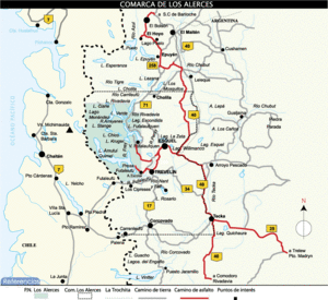
Los Alerces National Park is made up of two main parts. There is the official national park, which covers about 187,379 hectares (723.5 square miles). Next to it is the Los Alerces National Reserve, which is about 71,443 hectares (275.8 square miles). Most of the visitor facilities are in the national reserve.
The park is roughly shaped like a rectangle. It stretches about 65 kilometers (40 miles) from north to south along the Chilean border. It is about 45 kilometers (28 miles) wide from east to west.
Rivers and Lakes of Los Alerces
All the water in Los Alerces National Park flows into the Futaleufú River. This river changes names several times as it flows through Argentina. The park is known for its chain of beautiful lakes, connected by short, fast-flowing rivers.
The chain starts with Lake Rivadavia. Water from Lake Rivadavia flows into the Rivadavia River, which then enters the smaller Green Lake. From Green Lake, the Arrayanes River flows out. This river then meets the water from Lake Menéndez before continuing to Futalaufquen Lake.
Below Futalaufquen Lake is Kruger Lake. The Frey River flows from here into the Amutui Quimey Reservoir, which is a lake made by people. Finally, the Futaleufú River flows out from the Amutui Quimey reservoir and forms the southern boundary of the National Park. Many smaller lakes and streams are scattered throughout the park's mountains and valleys.
The highest point in Los Alerces National Park is Cordon de las Pirámides, which is 2,440 meters (8,005 feet) high. The lowest point is about 330 meters (1,083 feet) where the Futaleufú river crosses into Chile.
Weather and Nature in the Park
The lower areas of Los Alerces National Park have a cool, moist climate. Clouds carrying moisture from the Pacific Ocean hit the Andes mountains on the border with Chile. This brings a lot of rain, up to 3,000 millimeters (118 inches) each year. At higher elevations, this precipitation falls as snow.
As you move eastward from the mountains, the rainfall quickly decreases. This is because of a "rain shadow" effect. At the eastern edge of the park, only about 800 millimeters (31 inches) of rain falls each year.
Temperatures and Seasons
Temperatures in the park range from cold to mild. It can even freeze during any month of the year. At the park headquarters, which is one of the lowest spots, the warmest month is January. The average high temperature is 24° Celsius (75° Fahrenheit), and the average low is 8° Celsius (46° Fahrenheit).
July is the coldest month. The average high temperature is 7° Celsius (45° Fahrenheit), and the average low is -1° Celsius (30° Fahrenheit). Temperatures get colder as you go higher up the mountains. The tree line is around 1,400 meters (4,600 feet). Above this, you'll find bare rock, snowfields, and the Torrecillas glacier between the two arms of Lake Menéndez.
Park's Diverse Forests
The western part of the park gets a lot of rain. Here, you'll find Valdivian temperate rain forests below the high Andes. Much of the rest of the park has Patagonian forests, similar to those in Lanín and Nahuel Huape National Park. These forests include trees like coihues and lenga. You can also see beautiful arrayán (Luma apiculata) trees along the Arrayanes river.
Even though there isn't a truly dry season, the park gets the most rain and snow during the Southern Hemisphere winter months, from July to August.
Fun Things to Do in Los Alerces
A hydroelectric dam in the park helps create energy for a city called Puerto Madryn. This dam also created the large Amutui Quimey Reservoir.
The park is a great place for walking and fishing. You can also take boat trips on the beautiful lakes. From tour boats on Lake Menéndez, you can even see the amazing Torrecillas glacier up close!
See also
 In Spanish: Parque nacional Los Alerces para niños
 | Selma Burke |
 | Pauline Powell Burns |
 | Frederick J. Brown |
 | Robert Blackburn |


