Sea Bright, New Jersey facts for kids
Quick facts for kids
Sea Bright, New Jersey
|
||
|---|---|---|
|
Borough
|
||
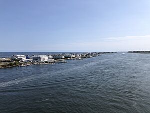
View of Sea Bright from the Highlands–Sea Bright Bridge, with the Shrewsbury River in the foreground and the Atlantic Ocean in the background (2024)
|
||
|
||
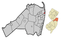
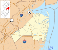
Map of Sea Bright in Monmouth County. Inset: Location of Monmouth County highlighted in the State of New Jersey.
|
||
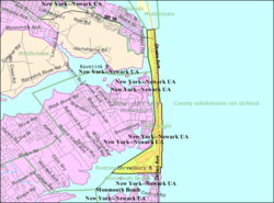
Census Bureau map of Sea Bright, New Jersey
|
||
| Country | ||
| State | ||
| County | Monmouth | |
| Incorporated | March 21, 1889 | |
| Government | ||
| • Type | Borough | |
| • Body | Borough Council | |
| Area | ||
| • Total | 1.29 sq mi (3.33 km2) | |
| • Land | 0.72 sq mi (1.86 km2) | |
| • Water | 0.57 sq mi (1.47 km2) 43.88% | |
| Area rank | 472nd of 565 in state 42nd of 53 in county |
|
| Elevation | 3 ft (0.9 m) | |
| Population
(2020)
|
||
| • Total | 1,449 | |
| • Estimate
(2023)
|
1,425 | |
| • Rank | 513th of 565 in state 47th of 53 in county |
|
| • Density | 2,013.1/sq mi (777.3/km2) | |
| • Density rank | 296th of 565 in state 35th of 53 in county |
|
| Time zone | UTC−05:00 (Eastern (EST)) | |
| • Summer (DST) | UTC−04:00 (Eastern (EDT)) | |
| ZIP Code |
07760
|
|
| Area code(s) | 732 | |
| FIPS code | 3402566240 | |
| GNIS feature ID | 0885387 | |
Sea Bright is a small town, called a borough, located on the beautiful Jersey Shore in Monmouth County, New Jersey. In 2020, about 1,449 people lived here.
Sea Bright became a borough on March 21, 1889. It was formed from parts of Ocean Township. The town was officially re-established in 1897.
The name "Sea Bright" might have come from a suggestion by Martha Bayard Stevens. Some people also think it was named after a place called Sea Bright, England, but there's no proof that place exists. In the past, the name was often spelled as one word, "Seabright."
Contents
History of Sea Bright
Early Days and Name Origin
In the early 1840s, Sea Bright was a simple fishing village with small shacks near the beach. The first hotel, Ocean House, opened in 1842, offering fishing and swimming. This area was first called "Nauvoo," which is a Native American word meaning "bright sea." Another idea is that the name comes from the Hebrew language and means "pleasant place." This is the same name that Mormon leader Joseph Smith gave to Nauvoo, a town he founded in Illinois. Smith is believed to have visited Monmouth County in 1840.
Connecting the Town: Bridges
The first bridge connecting Sea Bright to Rumson across the Shrewsbury River was built in 1870. Over the years, several bridges have been built. The bridge that connects to Ocean Avenue in Sea Bright was built in 1950. Because it was getting old and needed many repairs, a new bridge was planned. This new bridge project was completed in 2025. It has wider shoulders and other improvements, like modern controls for the drawbridge part. It also includes a ramp to Sea Bright Beach and upgrades to the nearby Sea Bright park.
The Sea Bright Skiff
The Sea Bright Skiff is a special type of boat that was created on the Jersey Shore in the early 1800s. It was designed for fishing in the ocean by being launched directly from the beach and then brought back to shore.
Geography and Beaches
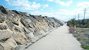
Sea Bright is a small area, covering about 1.29 square miles (3.33 square kilometers). A large part of this area, about 43.88%, is water.
The town is known for its beaches. There are seven private beach clubs that require membership, and they can be quite expensive with long waiting lists. However, there is also a large public beach in the center of town. You need to buy a beach badge to enter this public beach, and it has lifeguards to keep everyone safe. There is also a free public area called the Anchorage, which is popular for surfing but does not have lifeguards. Many public stairs also lead to other unguarded beaches for fishing and relaxing.
Sea Bright is located on a narrow strip of land, called a barrier peninsula. This strip of land separates the Atlantic Ocean from the Navesink and Shrewsbury rivers.
Population and People
Sea Bright has seen its population change over the years. In 2020, 1,449 people lived in the borough. The town is home to a mix of people of different ages and backgrounds.
Parks and Fun Activities
In the summer of 2015, Sea Bright added lifeguards and started charging a daily fee to visit Anchorage Beach. This area used to be free and popular with surfers. Now, it's one of the few oceanfront beaches in New Jersey that requires a fee to enter.
How Sea Bright is Governed
Local Government Structure
Sea Bright is run by a local government system called a "borough." This is a common way for towns to be governed in New Jersey. The town is led by a mayor and a borough council. Both the mayor and the council members are chosen by voters in the November elections.
The mayor is elected for a four-year term. The borough council has six members, and they serve three-year terms. Two council seats are up for election each year. In Sea Bright, the council has a lot of power, and the mayor mainly leads meetings and votes only if there's a tie. The mayor also helps assign council members to different committees.
As of 2025, the mayor of Sea Bright is Brian P. Kelly. The members of the Sea Bright Borough Council include William J. "Jack" Keeler, Erwin W. Bieber, Marc A. Leckstein, Samuel A. Catalano, Heather Gorman, and John M. Lamia Jr.
Education for Students
Public Schools in Sea Bright
Students in Sea Bright from kindergarten through eighth grade attend public schools in the Oceanport School District. The Sea Bright Board of Education was closed in 2009, so Oceanport now handles the education for these younger students.
The Oceanport School District has two schools:
- Wolf Hill Elementary School: For students in pre-kindergarten through 4th grade.
- Maple Place Middle School: For students in grades 5–8.
For high school, students in Sea Bright attend Shore Regional High School. This high school also serves students from nearby towns like Monmouth Beach, Oceanport, and West Long Branch. Shore Regional High School is located in West Long Branch. Sea Bright has one representative on the high school district's board of education.
Students in Sea Bright also have the chance to attend special career academies offered by the Monmouth County Vocational School District.
Getting Around Sea Bright
Roads and Highways
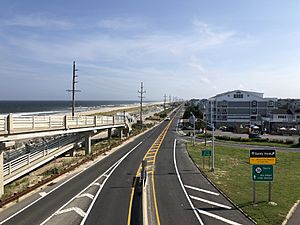
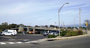
The main road through Sea Bright is Route 36. This road connects the town to Monmouth Beach to the south. Heading north, Route 36 crosses the Shrewsbury River over the Highlands–Sea Bright Bridge to Highlands. This bridge was built between 2008 and 2011.
You can also get to Sea Bright from Rumson to the west by taking Rumson Road, which is also known as County Route 520. The bridge for this road was replaced in 2025.
Public Transportation
If you need to travel by bus, NJ Transit offers local bus service. The 838 bus route connects Sea Bright to Red Bank.
Climate and Environment
Weather in Sea Bright
Sea Bright has a humid subtropical climate. This means it has warm, humid summers and mild winters. The hottest temperature ever recorded was about 99.8°F (37.7°C) in August 2001. Even though summer days often have a cool ocean breeze, it can sometimes get very hot and humid.
In winter, the average coldest temperature is around 5.3°F (-14.8°C). The coldest temperature ever recorded was -3.6°F (-19.8°C) in January 1985. Sea Bright usually gets about 18 to 24 inches (46 to 61 cm) of snow each winter. February is typically the snowiest month.
Local Plants and Nature
The natural plants in Sea Bright are mostly coastal prairie, with a lot of Northern Cordgrass. The area is in plant hardiness zone 7b, which means it can support certain types of plants based on how cold it gets in winter. New leaves usually appear in spring around March 23, and fall colors are at their best in early November.
Notable People from Sea Bright
Many interesting people have lived in or are connected to Sea Bright, including:
- Fred Alexander (1880–1969), a famous tennis player from the early 1900s.
- James Waddell Alexander II (1888–1971), a mathematician who taught at Princeton University.
- Edward Shippen Barnes (1887–1958), an organist and composer.
- Linda Chorney (born 1960), a singer-songwriter and filmmaker.
- Tal Farlow (1921–1998), a jazz guitarist.
- Lindley Miller Garrison (1864–1932), who served as the United States Secretary of War for President Woodrow Wilson.
- Jerry Gaskill (born 1957), the drummer for the rock band King's X.
- John J. McCook (1845–1911), a Civil War officer and lawyer.
- Mildred Mottahedeh (1908–2000), a collector of ceramics and a businessperson.
- Melissa Stark (born 1973), a television reporter and sportscaster for the NFL Network.
- Martha Bayard Stevens (1831–1899), a kind person who helped others and is believed to have suggested the town's name.
- Juan Trippe (1899–1981), who founded the airline Pan Am.
- Charles L. Walters (circa 1862–1894), a politician who was mayor of Sea Bright.
Images for kids
See also
 In Spanish: Sea Bright para niños
 | Leon Lynch |
 | Milton P. Webster |
 | Ferdinand Smith |


