Lower Tenthill, Queensland facts for kids
Quick facts for kids Lower TenthillQueensland |
|||||||||||||||
|---|---|---|---|---|---|---|---|---|---|---|---|---|---|---|---|

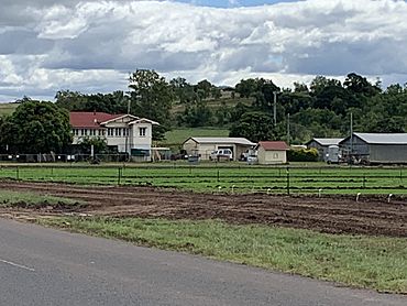
Houses and fields of lettuce, Lower Tenthill, 2022
|
|||||||||||||||
| Population | 236 (2021 census) | ||||||||||||||
| • Density | 9.04/km2 (23.4/sq mi) | ||||||||||||||
| Postcode(s) | 4343 | ||||||||||||||
| Area | 26.1 km2 (10.1 sq mi) | ||||||||||||||
| Time zone | AEST (UTC+10:00) | ||||||||||||||
| Location | |||||||||||||||
| LGA(s) | Lockyer Valley Region | ||||||||||||||
| State electorate(s) | Lockyer | ||||||||||||||
| Federal Division(s) | Wright | ||||||||||||||
|
|||||||||||||||
Lower Tenthill is a small rural area in Queensland, Australia. It is located in the Lockyer Valley Region. This area is known for its farming. In 2021, about 236 people lived in Lower Tenthill.
Contents
Exploring Lower Tenthill's Geography
Lower Tenthill is a place with many creeks. Tenthill Creek flows through the area. It forms part of the boundaries to the southwest and northeast. Farmers use the land along this creek for growing crops.
Water Features
The Lower Tenthill Weir is a special dam on Tenthill Creek. It can hold 70 million litres of water. This water helps to refill the underground water supplies. This process is called recharging groundwater. The northern edge of Lower Tenthill follows Lockyer Creek. Two other creeks, Ma Ma Creek and Deep Creek, also flow through the area. All these creeks are part of the North East Coast drainage basin. This means their water eventually flows towards the coast.
Roads and Travel
Two main roads help people get around Lower Tenthill. The Gatton-Helidon Road runs near the northern boundary. The Gatton–Clifton Road (also known as State Route 80) crosses the area. It goes from the north to the west.
A Look at Lower Tenthill's History
The name Tenthill comes from a large farming property. This property was set up by Phillip Friell around 1845.
Tent Hill Lower State School
The first school in the area opened in 1873. It was called Tent Hill State School. A few years later, in 1876, its name changed to Tent Hill Lower State School. People often called it Lower Tent Hill State School.
Population Changes in Lower Tenthill
The number of people living in Lower Tenthill has changed over the years.
- In 2011, there were 333 people.
- By 2016, the population was 252 people.
- In 2021, the population was 236 people.
Education in Lower Tenthill
Tent Hill Lower State School is the local primary school. It teaches students from Prep to Year 6. The school is located at 90 Lower Tenthill Road. In 2017, about 66 students attended the school. There were 6 teachers and 5 other staff members. In 2018, the school had 69 students, 5 teachers, and 6 other staff.
There are no high schools directly in Lower Tenthill. Students who want to go to high school usually attend Lockyer District State High School. This school is in the nearby town of Gatton.
 | Anna J. Cooper |
 | Mary McLeod Bethune |
 | Lillie Mae Bradford |


