Lowes Island, Virginia facts for kids
Quick facts for kids
Lowes Island, Virginia
|
|
|---|---|
| Country | |
| State | |
| County | |
| Area | |
| • Total | 3.16 sq mi (8.19 km2) |
| • Land | 3.02 sq mi (7.81 km2) |
| • Water | 0.14 sq mi (0.37 km2) |
| Elevation | 300 ft (90 m) |
| Population
(2010)
|
|
| • Total | 10,756 |
| • Density | 3,565/sq mi (1,376.4/km2) |
| Time zone | UTC−5 (Eastern (EST)) |
| • Summer (DST) | UTC−4 (EDT) |
| ZIP code |
20165 (Sterling)
|
| FIPS code | 51-47296 |
| GNIS feature ID | 2584870 |
Lowes Island is a special kind of community in Loudoun County, Virginia, United States. It's called a census-designated place (CDP). This means it's an area that the government counts for population, but it's not an official town or city.
In 2010, about 10,756 people lived in Lowes Island. It's part of the larger Potomac Falls area, along with nearby Countryside and Cascades. The community gets its name from an island in the nearby Potomac River.
Contents
Exploring Lowes Island's Location
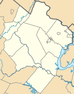
Lowes Island is located in the eastern part of Loudoun County. To its east, you'll find Fairfax County, Virginia. Across the Potomac River to the north is Montgomery County, Maryland.
Neighboring Communities and Cities
Lowes Island has several neighbors. To the east is Great Falls. To the south, you'll find Sugarland Run. Cascades is to the west, and Darnestown, Maryland is to the northeast.
Lowes Island is about 26 miles (42 km) northwest of downtown Washington, D.C.. It's also about 15 miles (24 km) east of Leesburg, which is the main town of Loudoun County.
Land and Water Features
The U.S. Census Bureau says that Lowes Island covers a total area of about 3.2 square miles (8.2 square kilometers). Most of this area, about 3.0 square miles (7.8 square kilometers), is land. The rest, about 0.15 square miles (0.4 square kilometers), is water.
A stream called Sugarland Run forms the western edge of Lowes Island. This stream flows north and eventually joins the Potomac River at the actual Lowes Island.
The Island's Name and History
The community's name comes from a real island in the southern part of the Potomac River. This island is now home to the Trump National Golf Club Washington, D.C.. Donald Trump bought this golf club in 2009. Before that, it was known as the Lowes Island Club.
On the golf club property, there is a monument called the "River of Blood" monument. This memorial was put up to remember a Civil War event.
See also
 In Spanish: Lowes Island (Virginia) para niños
 | Tommie Smith |
 | Simone Manuel |
 | Shani Davis |
 | Simone Biles |
 | Alice Coachman |


