Lyrup, South Australia facts for kids
Quick facts for kids LyrupSouth Australia |
|||||||||||||||
|---|---|---|---|---|---|---|---|---|---|---|---|---|---|---|---|

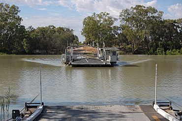
Lyrup Ferry
|
|||||||||||||||
| Established | 1894 | ||||||||||||||
| Postcode(s) | 5343 | ||||||||||||||
| Time zone | ACST (UTC+9:30) | ||||||||||||||
| • Summer (DST) | ACDT (UTC+10:30) | ||||||||||||||
| LGA(s) | Renmark Paringa Council | ||||||||||||||
| State electorate(s) | Chaffey | ||||||||||||||
| Federal Division(s) | Barker | ||||||||||||||
|
|||||||||||||||
Lyrup is a small town in the Riverland area of South Australia. It sits right on the banks of the famous Murray River. Lyrup is about 267 kilometres (166 miles) northeast of Adelaide, which is the capital city of South Australia. It's also only 25 kilometres (15.5 miles) from the town of Renmark.
Getting to Lyrup
One of the cool things about Lyrup is how you get there. You can reach the town by taking a special ferry across the river. This ferry helps connect Lyrup to the nearby areas.
Lyrup's Unique History
Lyrup was started a long time ago, in 1894. The government of South Australia created it as part of a plan to set up "village settlements." These were places where land was shared by the whole community. It was one of twelve such settlements created back then. When Lyrup first began, 243 people came to live there. The town was officially named Lyrup on September 24, 1896. It got its name from an old shack called "Lyrup's Hut."
Lyrup Today
Even now, Lyrup still uses its unique community land system. This means that the land is owned and managed by the community together. The town has a community club where people can gather. There's also a general store where you can buy things. If you visit, you can enjoy the picnic areas along the river. The farms around Lyrup grow many different crops. These include grapes, stone fruit like peaches, citrus fruits, almonds, and apricots. They also grow some corn.
 | William Lucy |
 | Charles Hayes |
 | Cleveland Robinson |


