
Lytle, Texas facts for kids
Quick facts for kids
Lytle, Texas
|
|
|---|---|

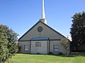
St. Andrew the Apostle Catholic Church in Lytle (established December 8, 1948)
|
|
| Motto(s):
A city on the grow!
|
|

Location of Lytle in Texas
|
|

Location of Lytle in Atascosa County
|
|
| Country | United States |
| State | Texas |
| Counties | Atascosa, Medina, Bexar |
| Area | |
| • Total | 4.81 sq mi (12.45 km2) |
| • Land | 4.76 sq mi (12.33 km2) |
| • Water | 0.05 sq mi (0.12 km2) |
| Elevation | 715 ft (218 m) |
| Population
(2020)
|
|
| • Total | 2,914 |
| • Density | 605.8/sq mi (234.06/km2) |
| Time zone | UTC-6 (Central (CST)) |
| • Summer (DST) | UTC-5 (CDT) |
| ZIP code |
78052
|
| Area code(s) | 830 |
| FIPS code | 48-45288 |
| GNIS feature ID | 2410903 |
Lytle is a city in Texas, United States. It is special because it is located in three different counties: Atascosa, Bexar, and Medina. In 2020, about 2,914 people lived there. Lytle is also part of the larger San Antonio area.
Contents
History of Lytle
Lytle started on a piece of land that was given to Henry Volkner in 1856. This land was near the beginning of Atascosa Creek. In 1870, Volkner sold this land to Fitch S. Adams. Lytle's very first school was built on Adams' property. Everyone agreed that the land would belong to the school as long as the building was there.
How the Railroad Shaped Lytle
In 1881, the International–Great Northern Railroad wanted to build a new station. They first tried to get land from B. G. Andrews. But there was a problem with the land agreement, and Mr. Andrews decided not to give the land.
So, in 1882, a cattleman named Captain John Thomas Lytle found new land about three miles away. One morning, railroad workers moved the entire "Andrews Station" building onto two train cars! They moved it to the new spot near the Lytle-McDaniel Ranch. This new location became known as Lytle, or Lytle Station.
Early Days of the Town
When Lytle got its own post office in 1883, the town also had a general store, a bar, and a person who made caskets, W. J. Garnand. He became the first postmaster, which is the person in charge of the post office.
By 1884, Lytle had about 50 people. It had a church that welcomed different groups, a school, a hotel, and a doctor. By 1892, the population had doubled to 100 people. The town then had four general stores, two places for raising livestock, and a Methodist church.
Growing the Economy
In its early days, Lytle's main jobs were farming and raising cattle. Lytle became a very important place for shipping cattle by train. The old pens where cattle were kept and the loading chute were famous landmarks for many years. They were finally removed in the late 1960s and early 1970s.
Cotton and corn were also big crops. There were special machines called cotton gins in Lytle and a nearby town called Benton City. In the late 1890s, people also started mining coal, which helped the local economy. By 1896, the population reached 150.
By 1914, Lytle had grown even more. It had telephone service, more stores, two lumberyards, and its own weekly newspaper called The Herald. The population reached 600 people, and Lytle School had 127 students. During the Great Depression, the school was made bigger as part of a WPA project, which was a government program to create jobs.
Modern Developments
After World War II, the town's Chamber of Commerce and property owners worked together to raise money to pave the streets. Later, in 1951, Lytle officially became an incorporated city. This meant it could have its own local government.
In 1955, people voted to get city water service by drilling a well. The Lytle Volunteer Fire Department was also started that year. More improvements came later: a gas system in 1960 and a sewer system in 1961. More streets were paved in 1971, and garbage removal and ambulance services were added in 1974. Since then, Lytle has continued to grow and improve.
Geography of Lytle
Lytle is mostly in the northern part of Atascosa County. Only small parts of the city stretch into Bexar and Medina counties.
A major highway, Interstate 35, runs through the southeastern part of Lytle. You can get onto it from Exit 131. Lytle's main street is Texas State Highway 132. This road used to be part of U.S. Route 81. It goes southwest to towns like Natalia and Devine before joining back with I-35.
San Antonio is about 25 miles (40 km) northeast of Lytle if you take I-35. Laredo is about 133 miles (214 km) to the south.
The city covers a total area of about 4.5 square miles (11.66 square kilometers). Most of this area is land, with a small amount of water.
Climate in Lytle
Lytle has a climate with hot and humid summers. The winters are generally mild to cool. This type of weather is known as a humid subtropical climate.
Population Information
| Historical population | |||
|---|---|---|---|
| Census | Pop. | %± | |
| 1960 | 798 | — | |
| 1970 | 1,298 | 62.7% | |
| 1980 | 1,920 | 47.9% | |
| 1990 | 2,255 | 17.4% | |
| 2000 | 2,383 | 5.7% | |
| 2010 | 2,492 | 4.6% | |
| 2020 | 2,914 | 16.9% | |
| U.S. Decennial Census | |||
2020 Census Details
As of the 2020 United States census, there were 2,914 people living in Lytle. These people made up 760 households, with 577 of them being families.
Here's a look at the different groups of people living in Lytle in 2020:
| Race | Number | Percentage |
|---|---|---|
| White (NH) | 820 | 28.14% |
| Black or African American (NH) | 21 | 0.72% |
| Native American or Alaska Native (NH) | 7 | 0.24% |
| Asian (NH) | 16 | 0.55% |
| Pacific Islander (NH) | 1 | 0.03% |
| Some Other Race (NH) | 12 | 0.41% |
| Mixed/Multi-Racial (NH) | 33 | 1.13% |
| Hispanic or Latino | 2,004 | 68.77% |
| Total | 2,914 |
Education in Lytle
Most of Lytle is served by the Lytle Independent School District. This district is home to the Lytle High School Pirates! A small part of Lytle, the area in Bexar County, is served by the Southwest Independent School District. Another small part is in the Natalia Independent School District.
Gallery
-
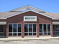
U.S. Post Office in Lytle
-
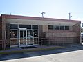
Lytle Community Center
-
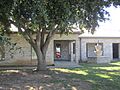
Lytle City Hall
-
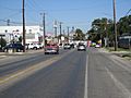
Downtown Lytle
-
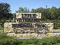
Veterans Memorial Park in Lytle
-
Trinity Baptist Church in Lytle


See also
 In Spanish: Lytle (Texas) para niños
