
Madera Canyon (Arizona) facts for kids
Quick facts for kids Madera Canyon |
|
|---|---|
| White House Canyon | |

The canyon floor.
|
|

Madera Canyon
Location in Arizona
|
|
| Floor elevation | 3,562 feet (1,086 m) |
| Geography | |
| Location | Santa Rita Mountains, Arizona, US |
| Topo map | USGS Mount Hopkins, AZ |
| Rivers | Madera Creek |
Madera Canyon is a beautiful canyon located in the Santa Rita Mountains in Arizona. It's about 25 miles southeast of Tucson. This canyon is part of the Coronado National Forest. It offers many fun activities like camping, picnicking, and miles of hiking trails.
Madera Canyon is also a very important spot for birds. Many birds stop here during their long journeys. This makes it a top place for birdwatching. The canyon was first called White House Canyon because a large white adobe house was built there a long time ago. It was renamed Madera Canyon in the early 1900s, but some local people still use its old name.
Contents
Amazing Animals and Plants in Madera Canyon

Madera Canyon is found in the Santa Rita Mountains. These mountains are one of the biggest "Madrean Sky Islands". These "sky islands" are like tall, cool mountains surrounded by hot, dry desert. This means Madera Canyon has a huge variety of flora (plants) and fauna (animals). You can find everything from cactus in the lower, warmer parts to aspen and pine forests higher up on Mount Wrightson.
Birdwatching Paradise
Madera Canyon is famous for its birds. It's considered one of the best birdwatching spots in the United States! Over 256 different kinds of birds have been seen here. This includes 15 types of hummingbirds and 36 kinds of wood warblers. You might also spot unique birds like the elegant trogon or the flame-colored tanager.
Other Wildlife
Besides birds, many other animals live in Madera Canyon. You might see black bears, mountain lions, and bobcats. There are also white-tailed and mule deer, foxes, coatis, ring-tailed cats, raccoons, and wild turkeys. Squirrels and rabbits are common too. Scientists have even found 16 different kinds of bats living in the canyon!
Understanding Life Zones
Madera Canyon is shaped like a bowl. Water from springs and rain flows down side-canyons into Madera Creek. This creek system, along with the many plants along its banks, forms a special "riparian corridor". This corridor goes through all four of the canyon's "life zones," creating excellent homes for wildlife.
- Lower Sonoran Zone (0 to 4,500 feet): This zone is hot and dry. It has Sonoran Desert plants like desert trees, shrubs, and cactus. As you go higher, it changes to desert grassland with grasses and velvet mesquite trees.
- Upper Sonoran Zone (4,500 to 6,500 feet): This area is cooler and wetter than the Lower Sonoran Zone. It has woodlands with evergreen oaks, alligator juniper, and Mexican piñon pine.
- Transition Zone (6,500 to 8,000 feet): This zone has mild summers and cold winters. You'll find plants common in the Rocky Mountains here. Look for ponderosa pine, Gambel oak, and maples.
- Canadian Zone (8,000 to 9,500 feet): This is the highest and coolest zone. It's found on the tall peaks above the canyon. Plants like Douglas fir, white fir, and quaking aspen grow in this high-altitude area.
A Look Back: History of Madera Canyon


In the early 1900s, many people came to the Santa Rita Mountains looking for valuable minerals. More than a dozen mines were active in Madera Canyon alone.
Famous People and Places
One mine was owned by a very interesting person named Ben Daniels. He had been a marshal in famous old Western towns like Dodge City and Tombstone. He also fought in the Spanish–American War. Later, Daniels built a home in Madera Canyon. He was even elected sheriff of Pima County in 1920!
The Pennington family lived in the area in the 1870s. Their daughter, Josephine, was once kidnapped by Apaches. She was left for dead but bravely survived and found her way back home. Today, Josephine Peak is named after her. Other places in the canyon are also named after miners, ranchers, and early settlers.
Mount Wrightson, a prominent mountain nearby, was named after William Wrightson. He was a miner who was killed in 1865.
Developing the Canyon
In 1905, Madera Canyon and the Santa Rita Mountains became part of the new National Forest System. This meant the land would be protected. In 1911, a group of business people built several cabins in the canyon. They leased the land from the United States Forest Service (USFS).
Over the next few years, roads were improved, and cars became more common. Madera Canyon quickly became a popular summer getaway. In 1922, the Santa Rita Trails Resort was built. Even though the original lodge burned down, it was rebuilt in 1929. It became a year-round resort with cottages, a restaurant, a store, and a post office. In the 1930s, a Civilian Conservation Corps camp was in Madera Canyon. These workers built many rock walls that you can still see today.
The USFS continued to improve the canyon, but too many people caused problems like erosion and issues with water. So, it was decided that the houses on leased land had to be removed. More than 50 cabins were taken down between 1984 and 1991. Only a few homes on private land remain in Madera Canyon today.
The Historic White House


The White House was one of the first permanent buildings in Madera Canyon. It was likely built by a sheepherder in the late 1870s or early 1880s. Later, a family named Wellish used it as a summer home. They owned a store in Tucson and probably whitewashed the adobe building, which gave it its famous name. The White House was so well known that it became a landmark for finding mining claims in the area.
Later, a couple named Alcaro and Benita Morales lived in the house. Alcaro delivered their five children there. Sadly, Benita and her fifth child died during childbirth in 1921. They were buried together in a small plot near the house. The family continued to live there until Alcaro passed away in 1940.
In 2002, the USFS and a non-profit group called Friends Of Madera Canyon did an archeological dig at the site. Today, only a small part of one wall is left. But they were able to figure out where the walls and front door used to be. You can visit the site of the White House near the Proctor Road crossing in Madera Canyon by following a short, paved path.
Gallery
-
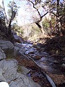
Madera Creek
-
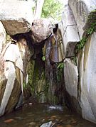
Proctor Falls in the summer of 2007.
-
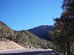
View of the Santa Ritas from Madera Canyon.
-
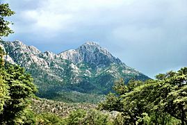
Mount Wrightson from Madera Canyon in 2012.


See also
 In Spanish: Cañón de Madera para niños
