Magnolia, Texas facts for kids
Quick facts for kids
Magnolia, Texas
|
|
|---|---|

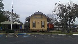
Historic train depot in downtown Magnolia
|
|
| Nickname(s):
Home of Red
|
|

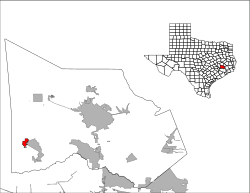
Location of Magnolia, Texas
|
|
| Country | United States |
| State | Texas |
| County | Montgomery |
| Founded | 1840's |
| Incorporated | October 15, 1968 |
| Government | |
| • Type | General Law Type A |
| Area | |
| • Total | 4.865 sq mi (12.600 km2) |
| • Land | 4.845 sq mi (12.547 km2) |
| • Water | 0.020 sq mi (0.053 km2) |
| Elevation | 272 ft (83 m) |
| Population
(2020)
|
|
| • Total | 2,359 |
| • Estimate
(2023)
|
5,320 |
| • Density | 1,098/sq mi (424.0/km2) |
| Time zone | UTC–6 (Central (CST)) |
| • Summer (DST) | UTC–5 (CDT) |
| ZIP Codes |
77353, 77354, 77355
|
| Area code(s) | 713, 281, 832, and 346 |
| FIPS code | 48-46056 |
| GNIS feature ID | 1340838 |
| Sales tax | 8.25% |
Magnolia is a city in southwestern Montgomery County, Texas, in the United States. It is part of the larger Houston area. The city gets its name from the beautiful magnolia trees that grow there. In 2020, about 2,359 people lived in Magnolia.
Contents
History of Magnolia
The area where Magnolia is now was first settled around 1845. A farmer named Mink built his home there, and the settlement was called Mink Prairie. By 1850, its name was shortened to Mink.
After the American Civil War, more people moved to Mink from places like Kentucky and Tennessee. This growth led to a post office being built in 1885.
In 1902, a railroad company, the International-Great Northern Railroad (now Union Pacific), decided to build a railway line north of Mink. Many residents moved closer to this new railroad. The new town was first named Melton, after a rich landowner. However, the postal service often mixed up "Melton" with another town called "Milton." Because of this confusion, local leaders changed the name to Magnolia. In 1903, the Mink post office moved to the new town of Magnolia, and the old town of Mink was eventually left empty.
Geography and Climate
Where is Magnolia?
Magnolia is located in Texas. The United States Census Bureau says the city covers about 4.865 square miles (12.600 square kilometers). Most of this area is land, with a very small part being water.
What is the Climate Like?
Magnolia has a climate with hot, humid summers. The winters are usually mild to cool. This type of weather is called a humid subtropical climate. On climate maps, it's known as "Cfa."
| Climate data for David Wayne Hooks Memorial Airport near Tomball, Texas, 1981–2010 normals, extremes 1888–present | |||||||||||||
|---|---|---|---|---|---|---|---|---|---|---|---|---|---|
| Month | Jan | Feb | Mar | Apr | May | Jun | Jul | Aug | Sep | Oct | Nov | Dec | Year |
| Record high °F (°C) | 84 (29) |
91 (33) |
96 (36) |
95 (35) |
99 (37) |
107 (42) |
105 (41) |
109 (43) |
109 (43) |
99 (37) |
89 (32) |
85 (29) |
109 (43) |
| Mean daily maximum °F (°C) | 61.5 (16.4) |
65.6 (18.7) |
72.1 (22.3) |
78.7 (25.9) |
85.7 (29.8) |
90.4 (32.4) |
93.1 (33.9) |
93.8 (34.3) |
89.2 (31.8) |
82.6 (28.1) |
71.7 (22.1) |
64.5 (18.1) |
79.1 (26.2) |
| Daily mean °F (°C) | 51.5 (10.8) |
55.1 (12.8) |
60.8 (16.0) |
67.9 (19.9) |
75.8 (24.3) |
80.8 (27.1) |
82.1 (27.8) |
82.6 (28.1) |
78.0 (25.6) |
70.1 (21.2) |
60.0 (15.6) |
52.9 (11.6) |
68.2 (20.1) |
| Mean daily minimum °F (°C) | 41.4 (5.2) |
44.7 (7.1) |
49.5 (9.7) |
57.1 (13.9) |
65.9 (18.8) |
71.2 (21.8) |
71.2 (21.8) |
71.4 (21.9) |
66.7 (19.3) |
57.5 (14.2) |
48.3 (9.1) |
41.2 (5.1) |
57.2 (14.0) |
| Record low °F (°C) | 5 (−15) |
6 (−14) |
21 (−6) |
31 (−1) |
42 (6) |
52 (11) |
62 (17) |
54 (12) |
45 (7) |
29 (−2) |
19 (−7) |
7 (−14) |
5 (−15) |
| Average precipitation inches (mm) | 3.55 (90) |
3.03 (77) |
3.59 (91) |
3.39 (86) |
4.77 (121) |
5.22 (133) |
3.84 (98) |
4.70 (119) |
4.57 (116) |
5.30 (135) |
4.72 (120) |
3.80 (97) |
50.48 (1,282) |
| Average precipitation days (≥ 0.01 in) | 9 | 8 | 9 | 7 | 8 | 10 | 10 | 8 | 8 | 8 | 8 | 10 | 101 |
| Source: NOAA (precipitation days 2000–2017 at Bush International) | |||||||||||||
People of Magnolia
Population Growth
The number of people living in Magnolia has grown quite a bit over the years. Here's a quick look at how the population has changed:
| Historical population | |||
|---|---|---|---|
| Census | Pop. | %± | |
| 1970 | 315 | — | |
| 1980 | 867 | 175.2% | |
| 1990 | 940 | 8.4% | |
| 2000 | 1,111 | 18.2% | |
| 2010 | 1,393 | 25.4% | |
| 2020 | 2,359 | 69.3% | |
| 2023 (est.) | 5,320 | 281.9% | |
| U.S. Decennial Census Texas Almanac: 1850-2000 2020 Census |
|||
Who Lives in Magnolia? (2020 Census)
The 2020 census counted 2,359 people living in Magnolia. There were 860 households, which are groups of people living together in one home.
The table below shows the different groups of people who live in Magnolia. "NH" means "Non-Hispanic," and the census counts people of Hispanic or Latino background separately, as they can be of any race.
| Race | Number | Percentage |
|---|---|---|
| White (NH) | 1,625 | 68.89% |
| Black or African American (NH) | 144 | 6.10% |
| Native American or Alaska Native (NH) | 9 | 0.38% |
| Asian (NH) | 28 | 1.19% |
| Pacific Islander (NH) | 0 | 0.00% |
| Some Other Race (NH) | 6 | 0.25% |
| Mixed/Multi-Racial (NH) | 120 | 5.09% |
| Hispanic or Latino | 427 | 18.10% |
| Total | 2,359 | 100.00% |
About 72.8% of the people were White, 6.2% were African American, and 18.1% were Hispanic or Latino.
Population in 2010
In the 2010 census, there were 1,393 people in Magnolia.
- About 29.7% of the population was under 19 years old.
- The average age of people in Magnolia was 37.8 years.
Arts and Culture
The Montgomery County Memorial Library System has a library branch in Magnolia called the Malcom Purvis Branch. It's a great place to find books and learn new things!
Education in Magnolia
Public Schools
The city of Magnolia is part of the Magnolia Independent School District. This district has schools for all ages:
- Younger students (grades K–4) go to Magnolia Elementary, Williams Elementary, or Smith Elementary.
- Students in 5th and 6th grade attend Magnolia Intermediate or Bear Branch Intermediate.
- For 7th and 8th grade, students go to Magnolia Junior High or Bear Branch Junior High.
- Older students (grades 9–12) attend either Magnolia West High School or Magnolia High School.
Colleges and Universities
After high school, students in Magnolia can attend Lone Star College. This college offers many different programs and courses.
Transportation and Roads
Magnolia is located where two important roads meet: FM 1488 and FM 1774. FM 1774 is also known as Magnolia Boulevard. These roads help people travel in and out of the city.
Famous People from Magnolia
Many interesting people have connections to Magnolia:
- Cecil Bell Jr. is a politician who serves in the Texas House of Representatives.
- Buddy Dial was a professional football player for the Pittsburgh Steelers and Dallas Cowboys.
- Michael Galloway was a politician in the Texas Senate.
- Marcus Luttrell is a United States Navy war hero. His story was told in the movie Lone Survivor.
- Morgan Luttrell is also a politician, serving in the United States House of Representatives.
- Nick Mitchell is a professional wrestler.
- Amanda Scarborough is a sports broadcaster for ESPN and used to play softball at Texas A&M.
- Jonathan Clay is a composer who has won a Tony award.
See also
 In Spanish: Magnolia (Texas) para niños
 | DeHart Hubbard |
 | Wilma Rudolph |
 | Jesse Owens |
 | Jackie Joyner-Kersee |
 | Major Taylor |

