Maitland River facts for kids
Quick facts for kids Maitland River |
|
|---|---|

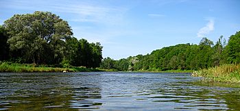
Maitland River west of Auburn, Ontario
|
|
|
Location of the mouth of the Maitland River in southern Ontario
|
|
| Country | Canada |
| Province | Ontario |
| Region | Southwestern Ontario |
| Counties |
|
| Physical characteristics | |
| Main source | Wellington North, Wellington County 447 m (1,467 ft) 43°54′58″N 80°39′22″W / 43.91611°N 80.65611°W |
| River mouth | Lake Huron Goderich, Huron County 176 m (577 ft) 43°44′55″N 81°43′38″W / 43.74861°N 81.72722°W |
| Length | 150 km (93 mi) |
| Basin features | |
| River system | Great Lakes Basin |
| Basin size | 2,592 km2 (1,001 sq mi) |
| Tributaries |
|
The Maitland River is a river in Ontario, Canada. It flows through Huron, Perth, and Wellington counties. This river is part of the Great Lakes Basin, which means its water eventually flows into the Great Lakes. The Maitland River ends by flowing into Lake Huron at the town of Goderich. It is about 150 kilometers (93 miles) long. The river was named after Sir Peregrine Maitland, who was a leader in Upper Canada from 1818 to 1828. Before this, it was known as the Menesetung River.
Contents
The River's Journey: From Source to Lake Huron
The Maitland River starts in a place called Wellington North in Wellington County. From there, it flows west into the town of Minto. It passes through Harriston, where three main highways meet.
The river continues west into Howick in Huron County. Here, it flows over two small dams. One dam is at Gorrie, and the other is at Wroxeter. After this, it goes through the area of Morris-Turnberry.
When the river reaches Wingham in North Huron, it flows over another dam. Here, a smaller river called the Middle Maitland River joins it. The Maitland River then turns southwest and enters Ashfield–Colborne–Wawanosh. From Auburn to Goderich, the river forms the border between Ashfield–Colborne–Wawanosh and Central Huron.
Finally, another smaller river, the South Maitland River, joins it. The Maitland River then turns northwest and reaches its end at Lake Huron in the town of Goderich.
The "Black Hole" of the River
Near Goderich, there is a deep spot in the river known as the "black hole." It is called this because the water is very deep and dark there. Sonar measurements have shown it is about six meters (20 feet) deep. This spot is located at 43°43′15″N 81°39′12.″W / 43.72083°N 81.65333°W. It is important to be careful around very deep parts of rivers.
River Life: Animals and Plants
The lower part of the Maitland River, up to Wingham, is a great place for fish. You can find trout and salmon here. The river is also home to several important and rare species. These include the queen snake, the wavy-rayed lampmussel, and the butternut tree.
You can also find special trees and plants that are common in the Carolinian forest region. These include the bitternut hickory, American sycamore, summer grape, and green dragon. These plants and animals help make the Maitland River a unique natural area.
Smaller Rivers and Streams: Tributaries
Many smaller rivers and streams flow into the Maitland River. These are called tributaries. They add water to the main river as it flows towards Lake Huron. Here are some of the tributaries of the Maitland River:
- Cemetery Creek (joins from the left side)
- Sharpes Creek (joins from the right side)
- Hopkins Creek (joins from the left side)
- South Maitland River (joins from the left side)
- Blyth Brook (joins from the left side)
- Belgrave Creek (joins from the left side)
- Middle Maitland River (joins from the left side)
- Little Maitland River
- Lakelet Creek (joins from the right side)
- Salem Creek (joins from the right side)
 | Tommie Smith |
 | Simone Manuel |
 | Shani Davis |
 | Simone Biles |
 | Alice Coachman |


