Goderich, Ontario facts for kids
Quick facts for kids
Goderich
|
|
|---|---|
| Town of Goderich | |
 |
|
| Motto(s):
Canada's Prettiest Town
|
|
| Country | Canada |
| Province | Ontario |
| County | Huron |
| Founded | 1827 |
| Incorporated | 1850 |
| Area | |
| • Total | 8.64 km2 (3.34 sq mi) |
| Elevation | 213 m (699 ft) |
| Population
(2016)
|
|
| • Total | 7,628 |
| • Density | 882.8/km2 (2,286/sq mi) |
| Time zone | UTC-5 (EST) |
| • Summer (DST) | UTC-4 (EDT) |
| Forward sortation area |
N7A
|
| Area code(s) | 519 and 226 |
| Website | www.goderich.ca |
Goderich is a town in the Canadian province of Ontario. It is the main town of Huron County. The town was started by John Galt and William "Tiger" Dunlop in 1827. It was named after Frederick John Robinson, 1st Viscount Goderich, who was the Prime Minister of the United Kingdom at that time. Goderich became an official town in 1850.
In 2016, about 7,628 people lived in Goderich. The town covers an area of 8.64 square kilometers.
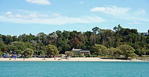
Goderich is located on the eastern shore of Lake Huron. It is known for its beautiful sunsets over the lake. Many people say that Goderich is "the prettiest town in Canada." Tourism is a very important industry for the town. Goderich has also won awards in the Communities in Bloom competition.
Contents
History of Goderich
The Canada Company bought a large area of land called the Huron Tract in 1826. In 1827, they set up their main office in what would become Goderich. The town started to grow by 1829. By 1850, about 1,000 people lived there, and it became an official town.
Dr. William "Tiger" Dunlop was also important in developing the area and founding Goderich. He was in charge of the forests for the Canada Company.
Early records show that the land was bought from the Chippewa First Nation. The town's location was chosen after surveys of the coast in 1824. The first building, a log cabin, was built in 1827. It was the home of Dr. William "Tiger" Dunlop and was called "The Castle."
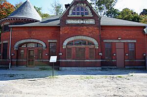
By 1846, Goderich had a working harbour. A lighthouse was also being built. Roads connected Goderich to other towns like Wilmot Township, Ontario and London, Ontario. People were already building ships there. By 1869, the population grew to 4,500. A railway station and steamship docks were in use. Wheat was a major crop shipped from the area.
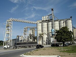
The first modern harbour was built in 1872. The railway arrived in June 1858, and a grain elevator was built in 1859. Fishing also became important, and the pier had many fish shanties. Goderich became a very busy place for shipping by train in the 1940s.
Salt mining became a big industry in 1866. Samuel Platt started opening salt mines near his flour mill. The harbour also had large flour mills starting in the 1870s.
The Goderich lighthouse was the first on the Canadian side of Lake Huron. It opened in 1847. A big storm on Lake Huron in November 1913 caused 19 ships to sink and 244 lives to be lost. Much of the wreckage washed ashore near Goderich.
In 1866, the town got water from four wells. This water was thought to have healing powers, which brought tourists to Goderich. The Ocean House Hotel, built in the 1850s, hosted many visitors. From about 1910, the sandy beaches were popular with locals and tourists. A "bathing house" with lockers and restrooms was built in 1930.
During World War II, the Goderich Airport became a training facility for pilots. It opened in December 1939 and closed in March 1945. A special airplane, a Lancaster X, was given to the town to honor those who served in the war.
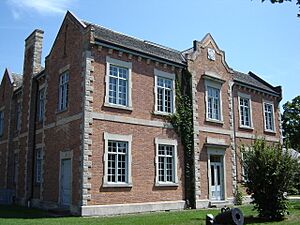
Goderich has many buildings that are recognized for their historical importance.
In 2022, the Mayor, John Grace, passed away. The Deputy Mayor, Myles Murdock, became the acting Mayor. Later, Myles Murdock was elected as the new Mayor of Goderich.
The Goderich Square
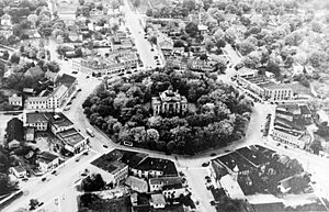
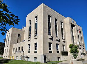
Goderich's downtown area has a unique eight-sided roundabout called 'The Square'. The county courthouse stands in the middle of The Square.
The Government of Canada officially recognized The Square as a historic place in 2007. The town had already seen its importance in 1982.
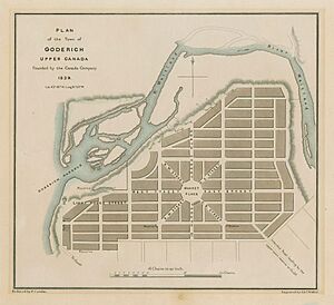
The Square was designed and built between 1840 and the 1890s. In its early days, it held the main office of the Canada Company. This company helped develop much of the county. The design of the square, with its "radial composition," is thought to be by John Galt. It was inspired by old Roman city plans. Over the years, it has been called "Market Square," "The Square," or "Courthouse Square." The original courthouse here was destroyed in a fire. A new building was put in its place in the 1950s.
2011 Tornado
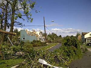
On August 21, 2011, a strong F3 tornado hit Goderich. It came from Lake Huron as a waterspout. This was the strongest tornado to hit Ontario since 1996. The storm caused a lot of damage. It knocked down power lines, ripped roofs off houses, and scattered cars and trees. Many old trees around the Goderich Courthouse were pulled out of the ground.
One person, Norman Laberge, 61, died while working on a dock. Thirty-seven people were hurt. The weather office sent out a tornado warning 12 minutes before the tornado hit. Goderich did not have a tornado siren at the time.
News reports said that 100 houses, 25 buildings, and thousands of old trees were badly damaged or destroyed.
Rebuilding The Square
After the tornado, many buildings around The Square had damaged roofs. The trees in the park around the courthouse were also damaged or uprooted.
A year later, most of the downtown businesses had reopened. However, rebuilding the courthouse, some historic buildings, and replanting trees took much longer.
By 2015, the park had reopened with a new band shell. New trees, plants, a statue, and a water feature were added in front of the courthouse. Much of the area around the park was rebuilt, including commercial buildings. The farmers' market and flea market also reopened.
Climate
| Climate data for Goderich, Ontario (Goderich Airport) 1991–2020, extremes 1866–present | |||||||||||||
|---|---|---|---|---|---|---|---|---|---|---|---|---|---|
| Month | Jan | Feb | Mar | Apr | May | Jun | Jul | Aug | Sep | Oct | Nov | Dec | Year |
| Record high °C (°F) | 17.2 (63.0) |
18.5 (65.3) |
25.1 (77.2) |
28.9 (84.0) |
32.0 (89.6) |
35.0 (95.0) |
37.2 (99.0) |
37.2 (99.0) |
35.0 (95.0) |
28.9 (84.0) |
23.1 (73.6) |
16.7 (62.1) |
37.2 (99.0) |
| Mean daily maximum °C (°F) | −1.3 (29.7) |
−0.6 (30.9) |
3.8 (38.8) |
10.6 (51.1) |
17.4 (63.3) |
22.4 (72.3) |
24.4 (75.9) |
24.0 (75.2) |
21.0 (69.8) |
14.3 (57.7) |
7.3 (45.1) |
1.7 (35.1) |
12.1 (53.8) |
| Daily mean °C (°F) | −4.6 (23.7) |
−4.3 (24.3) |
−0.3 (31.5) |
5.9 (42.6) |
12.3 (54.1) |
17.4 (63.3) |
19.6 (67.3) |
19.3 (66.7) |
16.1 (61.0) |
10.2 (50.4) |
4.1 (39.4) |
−1.1 (30.0) |
7.9 (46.2) |
| Mean daily minimum °C (°F) | −7.8 (18.0) |
−8 (18) |
−4.4 (24.1) |
1.1 (34.0) |
7.1 (44.8) |
12.4 (54.3) |
14.8 (58.6) |
14.5 (58.1) |
11.2 (52.2) |
6.0 (42.8) |
0.8 (33.4) |
−3.9 (25.0) |
3.7 (38.7) |
| Record low °C (°F) | −29.4 (−20.9) |
−32.8 (−27.0) |
−26.1 (−15.0) |
−17.8 (0.0) |
−7.8 (18.0) |
−5.0 (23.0) |
1.1 (34.0) |
1.1 (34.0) |
−3.9 (25.0) |
−11.1 (12.0) |
−24.4 (−11.9) |
−27.8 (−18.0) |
−32.8 (−27.0) |
| Average precipitation mm (inches) | 72.2 (2.84) |
54.9 (2.16) |
74.1 (2.92) |
77.4 (3.05) |
65.2 (2.57) |
76.4 (3.01) |
65.1 (2.56) |
80.9 (3.19) |
90.7 (3.57) |
80.0 (3.15) |
87.4 (3.44) |
101.4 (3.99) |
925.7 (36.44) |
| Average rainfall mm (inches) | 17.9 (0.70) |
20.8 (0.82) |
36.6 (1.44) |
67.1 (2.64) |
64.8 (2.55) |
76.4 (3.01) |
65.1 (2.56) |
80.9 (3.19) |
90.7 (3.57) |
74.5 (2.93) |
61.9 (2.44) |
41.3 (1.63) |
698.0 (27.48) |
| Average snowfall cm (inches) | 65.4 (25.7) |
48.6 (19.1) |
41.1 (16.2) |
11.8 (4.6) |
0.2 (0.1) |
0.0 (0.0) |
0.0 (0.0) |
0.0 (0.0) |
0.0 (0.0) |
9.2 (3.6) |
28.6 (11.3) |
72.3 (28.5) |
277.2 (109.1) |
| Average precipitation days (≥ 0.2 mm) | 19 | 15 | 16 | 13 | 12 | 11 | 10 | 10 | 12 | 13 | 17 | 20 | 168 |
| Average rainy days (≥ 0.2 mm) | 5 | 4 | 7 | 11 | 11 | 11 | 10 | 10 | 12 | 12 | 11 | 8 | 112 |
| Average snowy days (≥ 0.2 cm) | 17 | 14 | 11 | 5 | 0 | 0 | 0 | 0 | 0 | 4 | 8 | 16 | 75 |
| Source: Environment Canada (precipitation/rainfall/snowfall 1951–1980) | |||||||||||||
Population Data
| Historical populations | ||
|---|---|---|
| Year | Pop. | ±% |
| 1841 | 659 | — |
| 1871 | 3,954 | +500.0% |
| 1881 | 4,564 | +15.4% |
| 1891 | 3,839 | −15.9% |
| 1901 | 4,158 | +8.3% |
| 1911 | 4,522 | +8.8% |
| 1921 | 4,107 | −9.2% |
| 1931 | 4,491 | +9.3% |
| 1941 | 4,557 | +1.5% |
| 1951 | 4,934 | +8.3% |
| 1961 | 6,411 | +29.9% |
| 1971 | 6,813 | +6.3% |
| 1981 | 7,322 | +7.5% |
| 1991 | 7,452 | +1.8% |
| 2001 | 7,604 | +2.0% |
| 2006 | 7,563 | −0.5% |
| 2011 | 7,521 | −0.6% |
| 2016 | 7,628 | +1.4% |
In the 2021 Census, Goderich had a population of 7,881 people. They lived in 3,667 homes. This was a small increase from its 2016 population of 7,628. The town's land area is 8.54 square kilometers.
| 0-9 | 10-19 | 20-29 | 30-39 | 40-49 | 50-59 | 60-69 | 70-79 | 80+ | Total | % of population | ||||
|---|---|---|---|---|---|---|---|---|---|---|---|---|---|---|
| Male | 400 | 445 | 365 | 385 | 500 | 595 | 360 | 305 | 195 | 3,555 | 47 | |||
| Female | 335 | 485 | 405 | 375 | 585 | 630 | 435 | 400 | 360 | 4,010 | 53 | |||
| Total | 735 | 930 | 770 | 765 | 1,085 | 1,220 | 795 | 710 | 550 | 7,565 | 100 | |||
| Source: Stats Canada | ||||||||||||||
Goderich Economy

Huron County, where Goderich is located, is mostly known for farming. It produces a lot of crops, more than many other areas in Ontario. Goderich also has some factories, like those for Compass Minerals and Vestas.
The salt mining industry in Goderich is very old. In 1866, people looking for oil found a huge salt deposit about 300 meters underground.
Today, over 150 million tons of salt have been taken from the mine. By 2012, it could produce 9 million tons a year. This mine is 1,750 feet below the surface. It stretches 7 square kilometers under Lake Huron, which is about the size of the town itself. It is the largest underground salt mine in the world.
The salt in Goderich comes from an ancient sea bed from the Silurian age. This rock salt is also found in Windsor, Ontario. Companies like Canadian Salt Co./Windsor Salt Warehouse and Compass Minerals are involved in this industry.
Years ago, Volvo had a factory in Goderich that made road graders. This factory was originally owned by a local company called Champion Road Machinery. Volvo bought it in 1997. In 2008, Volvo decided to close the Goderich factory. Production stopped in 2009.
Tourism in Goderich
Tourism is important for Goderich. Many visitors come to enjoy the Lake Huron shore. Goderich has three beaches nearby. Visitors can shop or stay overnight in town. Goderich also has festivals and events every year.
The Huron Historic Gaol is a National Historic Site of Canada. It was the region's jail from 1842 until 1972. You can visit it between April and October. Famous people like James Donnelly Sr. and Steven Truscott were held here.
The Huron County Museum is a community museum. It has modern exhibits. You can see displays about the early settlement of Huron County. There is a full-size train, a World War II Sherman tank, and a large collection of military items. There is also an exhibit about salt mining. The museum also keeps historical records for Huron County.
Goderich has three public beaches. You can reach them by car by following signs to West Street. After parking, you can walk along a wooden boardwalk that is over a mile long. The main beach is at the north end of the walkway. It has sand and fine gravel. Swimmers can watch large ships loading salt on the other side of the pier. Further south is St. Christopher's beach. At the end of the boardwalk is "Rotary Cove." This is a family-friendly sand beach with lifeguards and playground equipment. There are also man-made structures called groynes along the beach. They help control how sand moves with the water currents.
Besides regular festivals, Goderich sometimes hosts special events. For example, during Goderich's 150th birthday, there was a Skydiving Jamboree at the Goderich Airport. Many parachutists from the U.S.A. and Canada came to this event.
Arts and Culture
Goderich Flag
Goderich has its own official flag. It was chosen in 1977 for the town's 150th birthday. A contest was held for all Goderich schools and residents. Judge Carter from St. Vincent St. won the contest. The flag shows a royal crown in the middle of an octagon. The octagon represents the town's unique eight-sided square. Three waves at the bottom on a blue background represent Lake Huron and the Port of Goderich.
The town also has a full town crest.
Sports and Recreation
Besides school teams, hockey is very popular in Goderich during the winter. The town supports the Jr. C Goderich Flyers hockey team. Many local players are on the Flyers team.
Town Infrastructure
Ports and Harbours
The Goderich Airport is also known as Sky Harbour Airport. It has three runways: two are paved and have lights, and one is grass. It is located north of the town. During World War II, the airport was a training school for pilots. Many aviation businesses are located near the airport. They offer services like painting, repairs, and mechanical work for planes.
Goderich Harbour is owned by the town. It is managed by Goderich Port Management Corporation. It is an industrial harbour. It is mainly used to load salt from the Sifto salt mines onto large ships.
Snug Harbour is a marina inside the industrial harbour. Maitland Valley Marina is also located near Goderich.
Railways
The Goderich-Exeter Railway currently moves freight (goods) by train to Goderich. This railway line was built in 1859. It was later taken over by CN. In 1992, the line was sold to GEXR.
The Canadian Pacific Railway built its own line into Goderich in 1907. Passenger trains ran until the 1960s. The entire line was closed in 1989. A bridge over the Maitland River was turned into a public walkway. It offers views of the harbour, golf course, and river valley.
Education
Public schools in Goderich are managed by the Avon Maitland District School Board. These include Goderich District Collegiate Institute (GDCI) for high school students. Goderich Public School teaches students from junior Kindergarten to grade 6. GDCI was founded in 1841. Goderich Public School was created by combining Victoria Public School and Robertson Memorial Public School.
Catholic schools are managed by the Huron-Perth Catholic District School Board. St. Mary's Catholic School is in Goderich. The closest Catholic high school is in Clinton.
Media
Newspaper
- The local newspaper is the Goderich Signal Star.
Radio Stations
AM
None
FM
- CIYN-FM-1 99.7 "Oldies" - plays classic hits
- CHWC-FM 104.9 "Today's Best Country" - plays country music and local news
- CKNX-FM 101.7 "The One" - plays adult contemporary music and local, regional, and national news
- CIBU-FM 94.5/91.7 "Cool 94.5" - plays classic rock music and local, regional, and national news
Notable People
- Albert Dewsbury (1926–2006) former NHL defenceman
- Gary Doak (1946-2017) former NHL defenceman
- William "Tiger" Dunlop (1792–1846) One of the founders of Goderich
- Brock Dykxhoorn (born 1994) Professional baseball player
- Brenda Elliott (born 1950) Former Ontario government minister
- Larry Jeffrey (1940 - 2022) former NHL forward, won the Stanley Cup in 1967
- C. E. McIntosh member of the Wisconsin State Assembly
- Ted Nasmith fantasy artist, known for illustrating works by J. R. R. Tolkien
- Jack Price (1932–2011) former NHL defenceman
- Jennifer Robinson (born 1976) former six-time Canadian national figure skating champion
- Tim Sale (born 1942), retired government Minister in Manitoba, Canada
- Dick Treleaven (born 1934) Ontario politician
- Steven Truscott, held in the local jail for some time
- Ron Van Horne (1932–2017) Ontario politician
 | Mary Eliza Mahoney |
 | Susie King Taylor |
 | Ida Gray |
 | Eliza Ann Grier |


