
Huron Tract facts for kids
| Huron Tract | |
| HuronTract.JPG | |
| Geography | |
| 1833-1953 area | 2,756,960 acres (11,157.0 km2) of land |
| History | |
| Origin | In 1825 in negotiations with the Chippewas of Chenail Ecarte, the Ausable River, and St. Clair River. |
| Created | 1827 |
| Abolished | 1835 |
| Succeeded by | Surveyed townships transferred to Huron, Middlesex and Kent counties |
Quick facts for kids Demography |
|
|---|---|
| 685. population | 1833 |
| 4804 population | 1839 |
The Huron Tract Purchase, also known as the Huron Block, was a huge area of land in southwestern Ontario. It bordered Lake Huron to the west and Lake Erie to the east. This land is now part of Huron, Perth, Middlesex, and Lambton County, Ontario.
The Huron Tract was bought by the Canada Company. This company was an agent for the British government. Its job was to give out land to new settlers in Upper Canada. Important people like William "Tiger" Dunlop and John Galt helped create the Canada Company. The company bought one million acres (4,000 km2) of land. They called this area the Huron Tract. The Canada Company managed the Huron Tract.
In 1825, a special law was passed to create the Canada Company. Its main goal was to settle the Huron Tract. The company officially started in 1826 and closed in 1953. In Britain, the government usually managed land. But in North America, private companies like the Canada Company often did this. The Canada Company and a powerful group called the Family Compact were very closely linked. This lasted until the Rebellions of 1837.
Contents
History of the Huron Tract


For 5,000 years, groups like the Huron, Algonquin, and Ojibwa used this land. They used it as summer homes for fishing and hunting. To protect their way of life, these tribes guided explorers north. They used waterways like the Magnetawan River to reach Georgian Bay and the Ottawa River.
The British Crown wanted to buy more land, including the Huron Tract. The Chippewas of Chenail Ecarte, the Ausable River, and St. Clair River talked with John Askin. He was the Superintendent of Indian Affairs. They negotiated the sale of this large area.

Land distribution in Upper Canada began with John Graves Simcoe. He was the first Lieutenant Governor of Upper Canada in the late 1700s. He wanted to divide land fairly. Upper Canada was split into three types of land:
- Crown land (for the government)
- Clergy land (for the church)
- Township land (for settlers)
This system worked for a while. But more land was needed as settlement grew. Also, the "Clergy Reserves" became a big problem. To make land distribution easier, the private Canada Company was formed. The Crown also continued to buy more land from Native peoples, like the Huron Tract.
How the Huron Block Changed
The First Nation Chiefs chose certain areas of land near Lake Huron to keep for their own use. These were called reserves:
| Reserve | Area |
|---|---|
| Upper Reserve on the St. Clair River (Sarnia) | 10,280 acres (41.6 km2) |
| Lower Reserve on the St. Clair River (Moore Township) | 2,575 acres (10.42 km2) |
| Mouth of the River aux Sable on Lake Huron | 2,650 acres (10.7 km2) |
| Kettle Point on Lake Huron | 2,446 acres (9.90 km2) |
The Canada Company bought one million acres of the Huron Block. This became known as the Huron Tract. The company planned to sell this land to settlers.
In 1835, the Huron Block townships were put into different counties:
| Huron County | Middlesex County | Kent County (Now in Lambton County) |
|---|---|---|
|
|
|
The townships that were once part of Huron County are now in these counties:
-
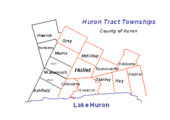
Huron County
-
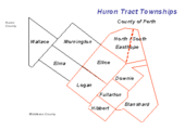
Perth County


The inclusion of Clergy reserves (land set aside for the Anglican Church) caused problems. Decisions about the Huron Tract were made in Britain, far from the colony. The Family Compact and Bishop John Strachan of the Anglican Church in Canada did not want these lands included. After much effort, the bishop got the lands back for the Church. This decision was one of the reasons for the Rebellion of 1837.
Where Township Names Came From
The Huron Tract was divided into 21 townships in 1824. Five townships were named after important British government members: Colborne, Goderich, Hay, Stanley, and Stephen. The other townships were named after members of the Canada Company's committee. Easthope Township was split into North and South because it was too big.
Some directors of the Canada Company, like Edward Ellice, Simon McGillivray, Hart Logan, and Henry Usborne, had lived in Canada. Edward Stanley, the 14th Earl of Derby, visited Canada in 1824.
Here are some townships named after Canada Company committee members from 1824:
- Biddulph Township for Robert Biddulph.
- Bosanquet Township for Charles Bosanquet.
- Colborne Township for Sir John Colborne (later John Colborne, 1st Baron Seaton).
- Downie Township for Robert Downie, a Member of Parliament (MP).
- Easthope Township (North & South) for Sir John Easthope, MP.
- Ellice Township for Edward Ellice, MP.
- Fullarton Township for John Fullarton.
- Goderich Township for Frederick John Robinson, who became Viscount Goderich.
- Hibbert Township for William T. Hibbert.
- Hullett Township for John Hullett.
- Logan Township for Hart Logan.
- McGillivray Township for Simon McGillivray.
- Stanley Township for Edward Stanley, MP.
- Stephen Township for James Stephen, MP.
- Williams Township for William Williams, MP.
- Usborne Township for Henry Usborne.
- Blanshard Township was named for Richard Blanshard, a Canada Company committee member from 1829.
- Hay Township was named for Robert William Hay. He was a government official for the colonies.
Rules for Buying Land
The rules for buying land in the Huron Tract were sometimes confusing. Here's how it generally worked:
Only United Englishmen, Loyalists, or those already allowed free land grants could get Crown lands without buying them. Loyalists were people who stayed loyal to the British Crown after the United States became independent. They moved to Canada and could get 200 acres of land for free. Other people had to buy land. Sales happened on the first and third Tuesday of every month. The land had a starting price. Buyers paid one-fourth of the price right away. The rest was paid in three equal payments each year, with 6% interest. Once all payments were made, the buyer received a special document for the land, free of charge.
The rules for who qualified for free land grants were debated. Sir John Robinson, 1st Baronet, of Toronto, a powerful politician, believed that people who became American citizens after 1783 should give up that citizenship to be considered Loyalists. But others disagreed. This disagreement was one of many issues that led to the Rebellions of 1837.
Historical Plaques

A plaque was put up to remember the pioneers of the Huron Tract. It says:
Pioneers of the Huron Tract 1828-1928
Commemorating the life work of the men who opened the roads, felled the forests, builded the farmsteads, tilled the fields, reaped the harvests—and of the women who made the homes, bore the children, nursed them, reared them, brightened and ennobled domestic life in the Huron Tract during a hundred years.
This plaque was put up by the Historic Sites and Monuments Board of Canada.
Other Related Plaques
- Colonel Anthony Van Egmond 1778-1838 (Anthony Van Egmond)
- The Founding of Goderich (Goderich, Ontario)
- Thomas Mercer Jones 1795-1868 (Thomas Mercer Jones)
- "Tiger" Dunlop 1792-1848 (William "Tiger" Dunlop)
- The Founding of Bayfield (Bayfield, Ontario)
- Fryfogel's Inn 1845, a building on the Huron Road.
- The Wilberforce Settlement 1830 (Wilberforce Colony)
Geography of the Huron Tract

In 1841, the Huron Tract was 1.2 million acres. More land was added later, bringing the total to over 1.7 million acres (6,900 km2). Eventually, the Huron Tract covered 2,756,960 acres.
William "Tiger" Dunlop described the land as mostly loamy or sandy loam. He noted limestone gravel near the lakes. The whole area had a lot of rich soil from plants. Dunlop also said the bedrock was mostly limestone with some sandstone.
Minerals Found Here
Near the lakeshores, there were rocks from the Serpentine group. Granite in red, silver, and gray colors could be seen. Pyrite, also known as fools gold, was found in clay slate. This was especially true at Kettle Point.
Rivers of the Huron Tract


The main rivers in the Huron Tract area are:
- Thames River (Ontario)
- Bayfield River
- Maitland River
- Nith River
- St. Clair River
- Ausable River (Lake Huron)
Land Features and Forests
The natural area of the former Huron Tract is called Mixedwood Plains. Most of the original thick forests are gone now. But some small parts of the old forest still remain. These forests have trees like eastern white pine, eastern hemlock, yellow birch, red pine, sugar maple, red oak, basswood, and white elm. Historically, the southwest part of the Huron Tract also had a small area of Carolinian forest, which has many deciduous trees.
| Ellice Swamp | |
|---|---|
| Location | Perth County, Ontario, Ontario, Canada |
| Named for | Named with reference to Ellice Township (Ontario) |
| Governing body | Upper Thames River Conservation Authority and Grand River Conservation Authority |
| Website | http://www.thamesriver.on.ca/wetlands_and_natural_areas/ellice_gadshill_swamps.htm |
A large cedar swamp was located in the townships of Ellice, Logan, McKillop, and Hullett. The biggest parts of this swamp are known as the Ellice Swamp and the Gads Hill Swamp. Both are located between Milverton and Stratford, Ontario. Ellice Swamp is 2,504 acres (1,013 ha). Gad Hill Swamp is 1,741 acres (705 ha). The Upper Thames River Conservation Authority owns most of Ellice and Gads Hill Swamps. The Grand River Conservation Authority owns the northern part of Ellice Swamp.
A smaller area is called Hullett Swamp or Hullett Provincial Wildlife Area. This wildlife area is currently 2,200 hectares (5,400 acres) along the South Maitland River in Huron County.
Environmental Importance
The former Huron Tract once had many important wetlands, swamps, and one of Ontario's largest deer yards. Today, 3.4% of the former Huron Tract is wetland. Ellice Swamp is a Class 2 Provincially Significant wetland. Other important wetlands in the area include:
- Dorchester Swamp (Class 1 wetland)
- Sifton Bog (Class 2 wetland)
- Golspie Swamp (Class 2 wetland)
Conservation Groups
These groups help protect the natural areas in the region:
- Maitland Valley Conservation Authority
- Ausable Bayfield Conservation Authority
- Upper Thames River Conservation Authority
- St. Clair Region Conservation Authority
See also
- List of cities and towns of Upper Canada
- The Canadas
- Former colonies and territories in Canada
- Timeline of Ontario history
