
Mangareva facts for kids

NASA picture of Mangareva Island
|
|

Mangareva
Location in French Polynesia
|
|
| Geography | |
|---|---|
| Location | Pacific Ocean |
| Coordinates | 23°06′35″S 134°58′15″W / 23.10972°S 134.97083°W |
| Archipelago | Gambier Islands |
| Area | 15.4 km2 (5.9 sq mi) |
| Length | 8 km (5 mi) |
| Highest elevation | 441 m (1,447 ft) |
| Highest point | Mt. Duff |
| Overseas collectivity | French Polynesia |
| Administrative subdivision | Îles Tuamotu-Gambier |
| Commune | Gambier Islands |
| Largest settlement | Rikitea |
| Demographics | |
| Population | 1,239 (2012) |
Mangareva is the largest and most important island in the Gambier Islands. These islands are part of French Polynesia. Mangareva is surrounded by smaller islands like Taravai, Aukena, and Akamaru.
In 2012, about 1,239 people lived on Mangareva. The main village, Rikitea, is the capital of the Gambier Islands.
Mangareva is about 8 kilometers (5 miles) long. It covers about 15.4 square kilometers (5.9 square miles). This is more than half of all the land in the Gambier group. The island has a tall ridge running through its middle. The highest point is Mount Duff, which is 441 meters (1,447 feet) high.
The island also has a large lagoon, about 24 kilometers (15 miles) wide. This lagoon has many reefs. The fish and shellfish in these reefs helped the early islanders survive. They had more food than people on nearby islands without reefs.
Contents
Exploring Mangareva's Past
Mangareva was first settled by Polynesians a long time ago. This was in the first 1,000 years after the year 0. Scientists have found settlements dating back to 1160–1220 CE. But there is also proof of trade with the Pitcairn Islands from 1000 CE. So, people likely settled on Mangareva around 800 CE.
The island used to be covered in thick forests. Many people lived there and traded with other islands using canoes. However, between the 10th and 15th centuries, the islanders cut down too many trees. This led to deforestation, which harmed the environment and the island's economy. You can learn more about this in the Gambier Islands article.
When Europeans Arrived
The first European to visit Mangareva was a British captain named James Wilson. He arrived in 1797 on his ship, the Duff. Captain Wilson named the island group after Admiral James Gambier. The Admiral had helped Wilson get his ship ready for the journey.
Mangareva's Rulers and French Control
Mangareva and the other Gambier Islands were ruled by kings and, later, by regents. A regent is someone who rules when the king is too young or unable to. Eventually, the French took control of the islands.
King Maputeoa asked France to protect his kingdom on February 16, 1844. But the French government never officially agreed to this. On February 4, 1870, the Mangarevan government, led by Prince Regent Arone Teikatoara, changed their minds. They officially took back their request for protection. They asked France not to get involved in their kingdom's business.
However, things changed again. On November 30, 1871, Prince Regent Arone signed a new agreement. This agreement with the French in Tahiti confirmed that the islands were under French protection. The Gambier Islands officially became part of France on February 21, 1881. This was approved by the President of France on January 30, 1882.
Nuclear Tests and Their Impact
In July 1966, the people of Mangareva were affected by nuclear tests. The French military conducted these tests on nearby islands like Moruroa and Fangataufa. The military knew that the islanders were exposed to radiation. They also knew about the possible effects, but they kept this information secret. A journalist named Vincent Jauvert made this information public in 1998. The French government finally admitted it in 2006.
Understanding Mangareva's Environment
Mangareva's Weather and Climate
Mangareva has a tropical rainforest climate. This means it's warm and rainy all year round. The average yearly temperature is about 23.5 degrees Celsius (74.3 degrees Fahrenheit). The island gets a lot of rain, about 1913.5 millimeters (75.3 inches) each year. November is usually the wettest month.
The warmest month is typically March, with an average temperature of about 26.0 degrees Celsius (78.8 degrees Fahrenheit). August is usually the coolest month, with an average of about 21.3 degrees Celsius (70.3 degrees Fahrenheit). The hottest temperature ever recorded was 31.4 degrees Celsius (88.5 degrees Fahrenheit) on March 6, 2016. The coldest was 13.2 degrees Celsius (55.8 degrees Fahrenheit) on August 27, 1992.
| Climate data for Mangareva (1991–2020 averages, extremes 1980–present) | |||||||||||||
|---|---|---|---|---|---|---|---|---|---|---|---|---|---|
| Month | Jan | Feb | Mar | Apr | May | Jun | Jul | Aug | Sep | Oct | Nov | Dec | Year |
| Record high °C (°F) | 31.2 (88.2) |
30.8 (87.4) |
31.4 (88.5) |
30.9 (87.6) |
29.6 (85.3) |
27.5 (81.5) |
26.9 (80.4) |
28.1 (82.6) |
27.7 (81.9) |
28.5 (83.3) |
29.1 (84.4) |
30.1 (86.2) |
31.4 (88.5) |
| Mean daily maximum °C (°F) | 28.0 (82.4) |
28.3 (82.9) |
28.4 (83.1) |
27.0 (80.6) |
25.4 (77.7) |
24.1 (75.4) |
23.4 (74.1) |
23.5 (74.3) |
23.8 (74.8) |
24.6 (76.3) |
25.8 (78.4) |
27.0 (80.6) |
25.8 (78.4) |
| Daily mean °C (°F) | 25.5 (77.9) |
25.8 (78.4) |
26.0 (78.8) |
24.9 (76.8) |
23.4 (74.1) |
22.2 (72.0) |
21.4 (70.5) |
21.3 (70.3) |
21.5 (70.7) |
22.3 (72.1) |
23.5 (74.3) |
24.7 (76.5) |
23.5 (74.3) |
| Mean daily minimum °C (°F) | 23.1 (73.6) |
23.4 (74.1) |
23.6 (74.5) |
22.7 (72.9) |
21.4 (70.5) |
20.3 (68.5) |
19.5 (67.1) |
19.1 (66.4) |
19.3 (66.7) |
20.1 (68.2) |
21.2 (70.2) |
22.3 (72.1) |
21.3 (70.3) |
| Record low °C (°F) | 18.5 (65.3) |
19.3 (66.7) |
18.3 (64.9) |
17.8 (64.0) |
16.0 (60.8) |
15.6 (60.1) |
13.9 (57.0) |
13.2 (55.8) |
14.6 (58.3) |
14.4 (57.9) |
16.6 (61.9) |
15.7 (60.3) |
13.2 (55.8) |
| Average precipitation mm (inches) | 187.4 (7.38) |
175.3 (6.90) |
167.2 (6.58) |
164.8 (6.49) |
174.1 (6.85) |
155.6 (6.13) |
127.9 (5.04) |
135.3 (5.33) |
119.9 (4.72) |
153.7 (6.05) |
165.8 (6.53) |
186.5 (7.34) |
1,913.5 (75.33) |
| Average precipitation days (≥ 1.0 mm) | 14.9 | 13.2 | 13.1 | 12.3 | 12.3 | 12.1 | 12.5 | 11.2 | 10.7 | 11.4 | 11.3 | 13.6 | 148.6 |
| Mean monthly sunshine hours | 216.7 | 194.4 | 203.5 | 155.3 | 142.5 | 123.4 | 135.7 | 154.8 | 150.7 | 164.7 | 174.1 | 180.5 | 1,996.1 |
| Source: Météo-France | |||||||||||||
Traveling to Mangareva
To reach Mangareva, you usually take a boat from the nearby airport. This airport is located across the lagoon.
Mangareva is also a key stop for people traveling to Pitcairn Island. Most travelers fly to Tahiti, then to Mangareva. From Mangareva, it's a long 32-hour boat ride to Pitcairn Island. Some people reach Pitcairn by cargo ships, but this is less common.
Mangarevan Culture and Stories
Books About Mangareva
Many authors have written about Mangareva. Painter and writer Robert Lee Eskridge wrote Manga Reva: The Forgotten Islands (1931). This book shares his observations about the island's environment, people, and traditions. It includes his own drawings and photos. Eskridge also wrote a children's book about his visit, called South Sea Playmates (1933).
Another writer, Garland Roark, mentioned Eskridge's work in his 1962 novel, The Witch of Manga Reva. Sailor and author W. I. B. (Bill) Crealock also wrote about his visit to Mangareva in his book Cloud of Islands. He thought Mangareva was the perfect island.
A Special Way to Count: Binary System
The people of Mangareva developed a unique binary number system. This happened centuries before Europeans invented their own binary system. In 2013, researchers found that the islanders had a special way to count using binary. This system used fewer digits than modern binary.
For example, the number 150 needs eight digits in regular binary (10010110). But in the Mangarevan system, it only needed four digits: VTPK. Here, V (varu) meant 80, T (tataua) was 40, P (paua) was 20, and K (takau) was 10.
Since other Polynesian societies didn't use binary counting, it likely developed on Mangareva. This happened between 1060 and 1360 AD. The modern binary system was invented by Gottfried Leibniz in 1689. This means the Mangarevan binary system was created 300 to 600 years earlier!
In 2020, it was shown that Mangarevan binary counting grew from a traditional Polynesian way of counting. Polynesian groups often counted different types of items in different ways. They counted items one by one, or in groups of two, four, or eight. Even then, they still used a decimal (base-10) system.
In Mangareva, counting items in groups of ten led to special words for numbers. For example, takau meant ten single items. Paua meant ten pairs (20). Tataua meant ten groups of four (40). And varu meant ten groups of eight (80).
With these words and values, binary counting became a simple change to their traditional system. In the old method, every tenth item was set aside to mark a group of ten. In Mangarevan binary, the first round of counting was the same. But in later rounds, items were grouped into eights (varu), then fours (tataua), twos (paua), and singles (takau). This change made the system binary, not decimal.
Mangarevan Gods and Myths
Mangarevan mythology includes gods and goddesses found across the Polynesian triangle. For example, the most important god in Mangareva was Tu. In New Zealand and Hawai'i, the god of war was also named Kū.
Other shared figures include the goddess Haumea. She is believed to have created the world. There is also the demi-god Māui. He is famous for fishing up islands from the bottom of the sea.
Images for kids
-
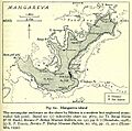
Map of Mangareva dated from 1938
-
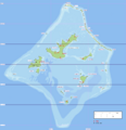
Location within the Gambier Islands
-
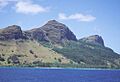
Mt. Duff, 366 meters (1,200 feet), the only volcanic remnant of all the original volcanoes which made up the Tuamotu archipelago
-
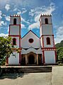
St Michael's Cathedral on Mangareva island
-
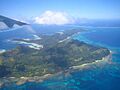
Aerial view
-
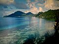
Coastal view


See also
- List of volcanoes in French Polynesia
