Mannington Township, New Jersey facts for kids
Quick facts for kids
Mannington Township, New Jersey
|
|
|---|---|
|
Township
|
|
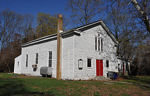
Church in the Marshalltown Historic District
|
|
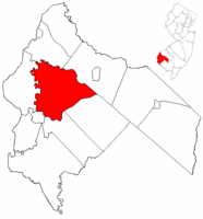
Mannington Township highlighted in Salem County. Inset map: Salem County highlighted in the State of New Jersey.
|
|
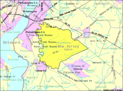
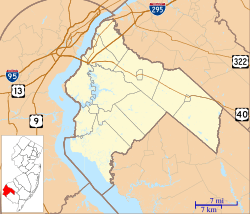
Census Bureau map of Mannington Township, New Jersey
|
|
| Country | |
| State | |
| County | Salem |
| Mentioned | May 12, 1701 |
| Incorporated | February 21, 1798 |
| Government | |
| • Type | Township |
| • Body | Township Committee |
| Area | |
| • Total | 37.90 sq mi (98.17 km2) |
| • Land | 33.88 sq mi (87.76 km2) |
| • Water | 4.02 sq mi (10.41 km2) 10.61% |
| Area rank | 62nd of 565 in state 4th of 15 in county |
| Elevation | 3 ft (0.9 m) |
| Population
(2020)
|
|
| • Total | 1,475 |
| • Estimate
(2023)
|
1,468 |
| • Rank | 512th of 565 in state 13th of 15 in county |
| • Density | 43.5/sq mi (16.8/km2) |
| • Density rank | 554th of 565 in state 14th of 15 in county |
| Time zone | UTC−05:00 (Eastern (EST)) |
| • Summer (DST) | UTC−04:00 (Eastern (EDT)) |
| ZIP Code |
08079 – Salem
|
| Area code(s) | 856 exchanges: 339, 769, 878, 935 |
| FIPS code | 3403343200 |
| GNIS feature ID | 0882133 |
| Website | |
Mannington Township is a township located in Salem County, New Jersey, in the United States. In 2020, about 1,475 people lived here. This was a decrease from 1,806 people counted in 2010.
Contents
History of Mannington Township
Mannington Township was first mentioned on May 12, 1701. Before that, it was known as East Fenwick Township in 1679. The township officially became a part of New Jersey on February 21, 1798. It was one of the first 104 townships created in the state.
In 1878, a part of Mannington Township became part of Quinton Township. The name "Mannington" comes from "Maneto" or "Manito." This was the name of a special spirit or god for the Lenape people, who were Native Americans.
Mannington Township is known as a "dry town." This means that the sale of alcohol is not allowed there by law. Some of the oldest buildings in the township include Barrett's Plantation House and the Salem County Insane Asylum.
Geography of Mannington Township
Mannington Township covers about 37.90 square miles (98.17 square kilometers). Most of this area is land, about 33.88 square miles (87.76 square kilometers). The rest is water, about 4.02 square miles (10.41 square kilometers).
The Salem River flows along the northern and western edges of the township. Mannington Township shares borders with several other towns in Salem County. These include Alloway Township, Carneys Point Township, Pennsville Township, Pilesgrove Township, Quinton Township, and Salem.
Several smaller communities and places are located within Mannington Township. Some of these are Acton, Claysville, Halltown, Marshalltown, Pointers, Portertown, Slapes Corner, Welchtown, and Welchville.
Population and People
| Historical population | |||
|---|---|---|---|
| Census | Pop. | %± | |
| 1810 | 1,664 | — | |
| 1820 | 1,732 | 4.1% | |
| 1830 | 1,726 | −0.3% | |
| 1840 | 2,064 | 19.6% | |
| 1850 | 2,187 | 6.0% | |
| 1860 | 2,393 | 9.4% | |
| 1870 | 2,351 | −1.8% | |
| 1880 | 2,230 | −5.1% | |
| 1890 | 1,870 | −16.1% | |
| 1900 | 1,745 | −6.7% | |
| 1910 | 1,606 | −8.0% | |
| 1920 | 1,456 | −9.3% | |
| 1930 | 1,584 | 8.8% | |
| 1940 | 1,656 | 4.5% | |
| 1950 | 1,686 | 1.8% | |
| 1960 | 2,024 | 20.0% | |
| 1970 | 1,913 | −5.5% | |
| 1980 | 1,740 | −9.0% | |
| 1990 | 1,693 | −2.7% | |
| 2000 | 1,559 | −7.9% | |
| 2010 | 1,806 | 15.8% | |
| 2020 | 1,475 | −18.3% | |
| 2023 (est.) | 1,468 | −18.7% | |
| Population sources: 1810–2000 1810–1920 1850–1870 1850 1870 1880–1890 1890–1910 1910–1930 1940–2000 2000 2010 2020 |
|||
2010 Census Information
In 2010, the township had 1,806 people living in 540 households. About 392 of these were families. The population density was about 53.6 people per square mile.
Most of the people were White (72.59%). About 21.10% were Black or African American. A smaller number were Native American (0.66%) or Asian (0.44%). About 8.19% of the population identified as Hispanic or Latino.
In terms of age, 18.3% of the people were under 18 years old. About 17.4% were 65 years old or older. The average age in the township was 41.4 years.
The average income for a household was about $63,650. For families, the average income was about $75,625. About 6.7% of the total population lived below the poverty line.
Economy of Mannington Township
Mannington Mills is a large company that has a factory in Mannington Township. This factory covers more than 500 acres (200 hectares). The company moved its operations here after it started in Salem in 1915. In 2010, the company worked to clean up contaminated soil at its plant site.
Education in Mannington Township
Students in Mannington Township attend public schools through a local school district.
Local Schools
The Mannington Township School District serves students from pre-kindergarten through eighth grade. These students go to Mannington Township School. In the 2021–22 school year, the school had 176 students and 21 teachers. This means there were about 8.4 students for every teacher.
High School Education
After eighth grade, students attend Salem High School in Salem City. Students from nearby Elsinboro Township, Lower Alloways Creek Township, and Quinton Township also go to this high school. In the 2021–22 school year, Salem High School had 399 students and 39 teachers.
Transportation in Mannington Township
Roads and Highways
As of 2010, Mannington Township had about 69.40 miles (111.69 kilometers) of roads. The township maintained 30.42 miles (48.96 kilometers) of these roads. Salem County maintained 32.36 miles (52.08 kilometers), and the state of New Jersey maintained 6.62 miles (10.65 kilometers).
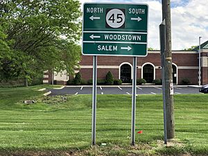
New Jersey Route 45 (Salem-Woodstown Road) is the main highway in the township. County Route 540 (Pointers Auburn Road) also runs through the area. These roads meet with Pointers Sharptown Road (County Route 620) at a place called Pointers. This name comes from the fact that the roads "pointed" toward Salem.
Public Transportation
NJ Transit offers bus service for people in Mannington Township. Bus route 401 connects Salem to Philadelphia. Route 468 provides local service between Penns Grove and Woodstown.
Freight Rail
The southern part of the Salem Branch freight rail line runs through Mannington. This line is about 18.6 miles (29.9 kilometers) long. It used to carry passengers but now only carries goods. Mannington Mills is one of the main businesses that uses this rail line.
Notable People from Mannington Township
Many interesting people have connections to Mannington Township. Some of them include:
- Collins B. Allen (1866–1953), who was the President of the New Jersey Senate.
- Robert Gibbon Johnson (1771–1850), a farmer famous for a story about him eating tomatoes. In 1820, he supposedly ate a basket of tomatoes in public to show they were not poisonous.
- George Washington Nicholson (1832–1912), an artist known for his landscape portraits.
- Bethanne McCarthy Patrick (born 1970), who has been a member of the New Jersey General Assembly since 2022.
- Thomas A. Pankok (1931–2022), a politician who served in the New Jersey General Assembly from 1982 to 1986.
See also
 In Spanish: Municipio de Mannington para niños


