Manor of Hougun facts for kids
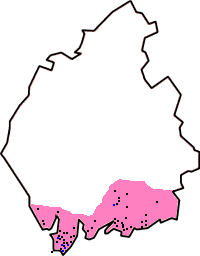
The Manor of Hougun was an old name for a part of what is now Cumbria in North West England. Back in 1086, when the famous Domesday Book was written, only the southern areas of Cumbria were recorded. The westernmost parts, like the Duddon and Furness Peninsulas, were mostly listed as belonging to the Manor of Hougun. The Domesday Book says that around 1060, this area was controlled by Tostig Godwinson, who was an important leader called the Earl of Northumbria.
Contents
Where Was Hougun?
People have argued for a long time about the exact spot of Hougun. Some think it was near Millom, while others suggest High Haume, close to Dalton-in-Furness. This is because High Haume was called Howehom in 1336, which sounds similar. It's also been suggested that the main part of the area was Furness. This might have included the Millom area and even parts of Cartmel. Some historians believe Hougun was a large administrative district, not just a single village.
What Does "Hougun" Mean?
The name "Hougun" likely comes from an old Norse word, haugr, which means "mound" or "hill". Interestingly, Walney Island, which is nearby at the western end of Morecambe Bay, was also known as the Island of Hougun (Houganai).
The Domesday Book of 1086
The Domesday Book entry for Hougun is very important. It helps us understand how much of the north-west of England the Normans controlled after their conquest. This was probably true until 1092, when William II of England took over Carlisle and northern Cumberland. North of the Hougun area, the land was part of Strathclyde/Cumbria, which was under Scottish rule.
Some experts think the Domesday entry gives us a glimpse of the "change between the Anglo-Norse and Norman worlds in the 11th century." It suggests that the Hougun area was mostly self-governing. It didn't have the same "shire" and "wapentake" system that was common further south in England.
Before the areas of Lancaster, Cumberland, and Westmorland were properly organized (around 1157-1182), parts of the Hougun area were separated. For example, Furness Abbey was given the Furness peninsula. Also, St Bees Priory received land from the Norman lord of Millom around 1125.
Hougun in the Domesday Book
The Domesday entry for Hougun lists different places and how much land they had. Land was measured in carucates in the north. A carucate was roughly the amount of land needed to support one household for a year.
Here's what the Domesday Book says about Hougun:
- In Hougun Manor, Earl Tosti had four carucates of land that could be taxed (called geld).
- All these villages belonged to Hougun:
- Chiluestreuic (Killerwick, now lost), 3 carucates.
- Sourebi (Sowerby), 3 carucates.
- Hietun (possibly Hawcoat), 4 carucates.
- Daltune (Dalton-in-Furness), 2 carucates.
- Warte (possibly Thwaite Flat), 2 carucates.
- Neutun (Newton, likely in Furness), 6 carucates.
- Walletun (Waltoncote, lost, probably in Furness), 6 carucates.
- Suntun (possibly Sunbrick/Stank, lost), 2 carucates.
- Fordebodele (Fordbootle, lost, maybe near Roose), 2 carucates.
- Rosse (Roose), 6 carucates.
- Hert (Hart, lost, probably near Gleaston Mill), 2 carucates.
- Lies (Leece), 6 carucates.
- Alia Lies (another Leece, lost), 2 carucates.
- Glassertun (Gleaston), 2 carucates.
- Steintun (Stainton), 2 carucates.
- Clivertun (Crivelton, lost, but might be near Newtown), 4 carucates.
- Ouregrave (Orgrave), 3 carucates.
- Meretun (Marton), 4 carucates.
- Pennigetun (Pennington), 2 carucates.
- Gerleuuorde (Ireleth), 2 carucates.
- Borch (possibly Broughton-in-Furness/Birkrigg), 6 carucates.
- Beretseige (Bardsea), 4 carucates.
- Witingham (Whicham), 4 carucates.
- Bodele (Bootle), 4 carucates.
- Santacherche (Kirksanton), 1 carucate.
- Hougenai (Walney), 6 carucates.
Other Nearby Places
The Domesday Book also mentions other places in the area, like:
- Ulvreston (Ulverston), 6 carucates, owned by Turulf.
- Dene (Dendron), 1 carucate.
- Bodeltun (Bolton-with-Adgarley), 6 carucates.
- Aldingham (Aldingham), 6 carucates, owned by Ernulf.
- Cherchebi (possibly Cartmel), owned by Dwan from the King.
- Holecher (Holker), owned by Orm from the King.
- Neutun (High and Low Newton), King's land.
- Bretebi (Birkby), owned by Orm from the King.
Further east, in what became Westmorland, other places are briefly mentioned. Most of these are in the low-lying areas around the Kent and Lune valleys.
See also
- List of Cumbria-related topics
Related reading
- Tristram Cole (2016) Tostig Godwinson, Earl of Northumbria (CreateSpace Independent Publishing Platform) ISBN: 978-1482351439
- Stephen E. Harding, David Griffiths, Elizabeth Royles (2014) In Search of Vikings: Interdisciplinary Approaches to the Scandinavian Heritage of North-West England (CRC Press) ISBN: 9781482207590
 | Janet Taylor Pickett |
 | Synthia Saint James |
 | Howardena Pindell |
 | Faith Ringgold |


