
Market Street (San Francisco) facts for kids

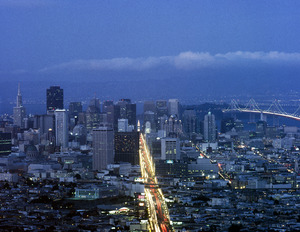
Market Street is conspicuous in the view from Twin Peaks.
|
|
| Owner | City and County of San Francisco |
|---|---|
| Maintained by | San Francisco DPW |
| Length | 3 mi (5 km) |
| Location | San Francisco, California |
| Nearest metro station | Embarcadero Station Montgomery Street Station Powell Street Station Civic Center/UN Plaza station |
| North East end | The Embarcadero |
| South West end | Portola Drive |
| Construction | |
| Commissioned | 1847 |
| Other | |
| Designer | Jasper O'Farrell |
Market Street is a very important street in San Francisco, California. It starts at The Embarcadero by the Ferry Building. This is at the city's northeast edge. The street then goes southwest through downtown San Francisco. It passes famous places like the Civic Center and the Castro District. Market Street ends where it meets Portola Drive in the Twin Peaks area.
Market Street is special because it divides two different street patterns. Streets on its southeast side run parallel or straight across Market Street. But streets on the northwest side are angled about nine degrees differently.
This street is a major route for public transportation in San Francisco. Over time, it has had many types of transport. These include horse-drawn streetcars, cable cars, electric streetcars, electric trolleybuses, and diesel buses. Today, Muni buses, trolleybuses, and old-fashioned streetcars (on the F Market line) all use Market Street. Below the street, the two-level Market Street subway carries Muni Metro trains and Bay Area Rapid Transit (BART). Even though cable cars don't run on Market Street anymore, their lines end very close by. You can find them at the intersections with California Street and Powell Street.
Contents
History of Market Street
How Market Street Was Planned

In 1839, the first street plan was made for Yerba Buena. This was a Mexican trading post. Jean Jacques Vioget designed this plan. Its streets mostly lined up with the main compass directions. Yerba Buena was renamed San Francisco in 1847. This happened after United States troops took it over during the Mexican–American War.
Market Street was first planned in 1847 by Jasper O'Farrell. He was a 26-year-old civil engineer. He designed Market Street to cut across the city for about 3 miles (4.8 km). It goes from the waterfront to the hills of Twin Peaks. People at the time said Market Street looked like an arrow pointing straight at Twin Peaks.
Property owners wanted O'Farrell to keep the older street plan from Vioget. They didn't want him to change roads to fit the hilly land. They also made him create a different angled street plan south of Market Street. This area was called Happy Valley. Market Street was designed to connect these two different street grids. It runs parallel to, and one block north of, Mission Street.
O'Farrell made Market Street the widest street in town. It was 120 feet (37 m) wide. But some property owners were upset about this. They thought the street was too wide. They worried it would take up too much of their land. O'Farrell even had to leave town for a while because of their anger.
At first, Market Street was blocked by large sand dunes. One dune was 60 feet (18 m) tall where the Palace Hotel is now. Another dune was 90 feet (27 m) tall further west. These dunes were leveled between 1852 and 1873. Workers used a steam shovel to move the sand. This machine was nicknamed "Steam Paddy." It was said to do the work of many men.
The sand was used to fill in parts of the bay. It also helped build the San Francisco and San Jose Railroad. Thousands of tons of sand were moved each day. This cleared about 5,000 acres (2,000 ha) of sand dunes. Some of these dunes were 60 feet (18 m) higher than Market Street is today.
Market Street Grows

The first horsecar railway line in San Francisco opened on Market Street. This happened on July 4, 1860. It was run by the Market Street Railroad Company. By 1918, Muni (San Francisco Municipal Railway) was competing with another company. Both had their own train tracks on Market Street. This led to a lot of noise, and people called it the 'roar of the four'.

In 1892, a company called The Owl Drug Company started at 1128 Market Street. It later became a very big drugstore chain in America.
Earthquake and Fire of 1906
-
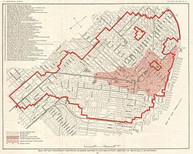
Map showing the area destroyed after the 1906 San Francisco earthquake and fire.
-
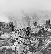
Market Street in ruins after the 1906 earthquake.
-
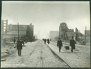
Market Street, looking southwest from near the Ferry Building in 1906.

.jpg)
.jpg)
On April 18, 1906, a big earthquake hit San Francisco. It lasted less than a minute. After the earthquake, a huge fire broke out. Many buildings along Market Street were destroyed. Some buildings were even blown up to stop the fire from spreading. The burned area reached from Dolores and Franklin streets all the way to the waterfront.
Within days, important citizens and property owners made plans to rebuild their buildings. Train services were moved to other streets. Repairs to the tracks on Market Street started quickly.


In 1908, Willis Polk designed special street lamps for Market Street. They were called the Path of Gold Street Lamps. These lamps were very fancy. They had sculptures of covered wagons, mountain lions, and gold prospectors. The city wanted these decorative poles. They helped make the overhead trolley wires look better, which many people didn't like.
Making Market Street Better
In the 1960s, people started thinking about how to improve Market Street. A group of business owners wanted to make it a better place for shopping and entertainment. They hired experts to come up with ideas.
One idea was to make Market Street only for buses and emergency vehicles. Another big change was moving the Muni streetcars underground. This happened as the Bay Area Rapid Transit (BART) system was being built. Construction for the Market Street subway started in 1967. This construction caused a lot of disruption. It led to a decline in the shopping area around mid-Market Street.
In 1980, Muni's streetcar operations mostly moved underground. Full changes happened in 1982. At first, there were no plans to keep the tracks on the surface. But special "Historic Trolley Festivals" in the 1980s were very popular. This led to the return of old streetcars on the F Market line.
Changes to Traffic

In 2009, San Francisco started trying to make Market Street safer. They wanted it to be more pleasant for people walking and biking. For a test, private cars were stopped from driving east from Sixth Street towards the Ferry Building. Drivers had to turn off Market Street. These changes were later made permanent.
In 2012, planning began to ban private cars from Market Street completely. This would be between Franklin and Steuart streets. The goal was to make it better for public transport, bikes, and pedestrians. In 2015, the city banned private vehicles from turning onto Market Street between Third and Eighth streets.
In December 2013, the city also launched free Wi-Fi internet access along Market Street.
The Better Market Street Project

A project called Better Market Street was started to improve how people get around. It focused on making the street better for walking, biking, and public transit. Early tests in 2009 stopped cars from making right turns on parts of the street.
The project faced some delays. But in 2020, it finally started being put into action. The plan included new ideas for bike lanes. It also aimed to change how buses and streetcars pick up passengers. There would be two sets of boarding areas. One set would be for faster, less frequent stops. The other would be for local service with more stops.
If the project is fully completed, it will cost a lot of money. It will also involve repaving sidewalks and fixing sewer lines under the street. In October 2019, the full plan was approved. This included stopping private cars from using most of Market Street.
The change to a car-free Market Street began on January 29, 2020. Studies showed that public transit trips on Market Street became 6-12% faster. There were also very few negative effects on traffic on other streets.
Market Street's Different Areas
Market Street can be thought of as having different "zones" or "sections." Each section has its own unique feel and purpose. Here are some of the main areas:
| Name | Where it is | What it's like |  |
|
|---|---|---|---|---|
| Embarcadero | Embarcadero | Fremont | This is the end of Market Street by the water. It connects the city to the Ferry Building and the waterfront. | |
| Financial | Fremont | 3rd | This part is very busy during weekdays with business people. It's quieter in the evenings and on weekends. | |
| Retail | 3rd | 5th | This is the main shopping area. It has many stores, department stores, and hotels. | |
| Mid-Market | 5th | 7th | This area has historic places like the Orpheum and Warfield theaters. They remind us that this used to be an entertainment district. | |
| Civic Center | 7th | Van Ness | Important landmarks here include the Civic Center, United Nations Plaza, and the San Francisco Main Library. There are also many arts and cultural places nearby. | |
| Octavia | Van Ness | Octavia | The buildings here are smaller. This area feels more like a neighborhood compared to other parts of Market Street. | |
Celebrations and Events

Market Street has often been the site for big parades and celebrations. These events have marked important moments in history. For example, there were parades for the Panama-Pacific International Exposition and the end of World War II.
On Christmas Eve in 1910, a famous opera singer named Luisa Tetrazzini sang a free concert outdoors. About 250,000 people came to listen! Another huge event was the New Year's Eve celebration at the Ferry Building on December 31, 1999. Over 1.2 million people filled Market Street and nearby areas to celebrate the start of a new century.
The San Francisco Gay Pride parade also takes place on Market Street. It attracts many people every year.
When the San Francisco Giants baseball team won the World Series, victory parades were held on Market Street. This happened in 2010, 2012, and 2014.
See also
 In Spanish: Market Street (San Francisco) para niños
