Marshyhope Creek facts for kids
Quick facts for kids Marshyhope Creek |
|
|---|---|

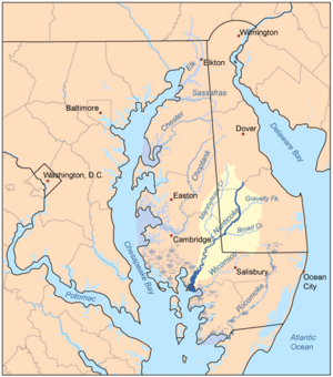
Map of the rivers of the Eastern Shore of Maryland with the Nanticoke and its watershed highlighted and showing Marshyhope Creek.
|
|
| Other name(s) | Tributary to Nanticoke River |
| Country | United States |
| State | Delaware Maryland |
| Counties | Kent (DE) Sussex (DE) Caroline (MD) Dorchester (MD) |
| Physical characteristics | |
| Main source | divide between Marshyhope Creek and Murderkill River Minners Corners, Delaware 60 ft (18 m) 38°55′18″N 075°38′27″W / 38.92167°N 75.64083°W |
| River mouth | Nanticoke River Walnut Landing, Maryland 0 ft (0 m) 38°31′38″N 075°45′24″W / 38.52722°N 75.75667°W |
| Length | 41.74 mi (67.17 km) |
| Basin features | |
| Progression | southwest |
| River system | Nanticoke River |
| Basin size | 41.74 square miles (108.1 km2) |
| Tributaries |
|
Marshyhope Creek is a cool waterway, about 37 miles (60 kilometers) long. It's like a smaller river that flows into a bigger one, the Nanticoke River. You can find it on the Delmarva Peninsula, which is a piece of land shared by Delaware, Maryland, and Virginia.
This creek starts in Kent County, Delaware. Then it travels through Caroline County and Dorchester County, Maryland in Maryland.
About Marshyhope Creek
Marshyhope Creek begins its journey in the southwestern part of Kent County, Delaware. This is close to the city of Harrington. From there, it flows until it reaches the Nanticoke River. The end point is near Sharptown, Maryland.
Where Does It Flow?
The entire area where Marshyhope Creek flows is called a "watershed." This watershed is part of the coastal plain. This means the land is mostly flat and close to sea level. At Federalsburg, the creek reaches sea level. This spot is also known as the "head of navigation." This means it's as far as boats can easily travel up the creek from the sea.
What Are Its Branches?
Just like a tree has branches, a creek has smaller streams that flow into it. These are called tributaries. Marshyhope Creek has many of these smaller branches.
On the western side of the creek, some of the smaller streams include:
- Faulkner Branch
- Sullivan Branch
- Capital Branch
- Green Branch
- Horsepen Arm
On the eastern side, you can find other small streams like:
- Tanyard Branch
- Houston Branch
- Jones Mill Branch
- Double Fork Branch
- Quarter Branch
- Tomahawk Branch
- Prospect Point Branch
These smaller branches help collect water from the surrounding land. They then carry it into Marshyhope Creek, making it bigger as it flows towards the Nanticoke River.
 | Kyle Baker |
 | Joseph Yoakum |
 | Laura Wheeler Waring |
 | Henry Ossawa Tanner |

