
Mattawoman Creek facts for kids
Quick facts for kids Mattawoman Creek |
|
|---|---|

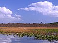
Freshwater-tidal estuary of Mattawoman Creek
|
|
| Country | United States |
| State | Maryland |
| Counties | Charles and Prince George's counties |
| Physical characteristics | |
| River mouth | Potomac River 0 feet (0 m) |
| Length | 30.0 miles (48.3 km) |
Mattawoman Creek is a 30.0-mile-long (48.3 km) waterway in Maryland, United States. It flows into the Potomac River near Indian Head, Maryland, about 20 miles (32 km) downstream from Washington, D.C..
The creek has two main parts. About 23-mile (37 km) of it is a regular river flowing through Prince George's and Charles counties. The other 7-mile (11 km) is a freshwater estuary in Charles County. An estuary is where a river meets the ocean, and the water mixes. For Mattawoman Creek, it's where the fresh river water meets the tidal water of the Potomac River.
Most of the land that drains into Mattawoman Creek, called its watershed, is in Charles County. The rest is in Prince George's County.
Contents
History of Mattawoman Creek
The name Mattawoman comes from an old Native American language called Algonquian. On a map made around 1608 by Captain John Smith, the creek was called Mataughquamend. This name means “where one goes pleasantly.”
Today, the Environmental Protection Agency (EPA) says Mattawoman Creek is "impaired." This means it's not as healthy as it should be. It has too many nutrients, too much dirt (sediment), and fewer living things than it should. This is a problem under the Clean Water Act.
However, Mattawoman Creek is also special. It's the southernmost freshwater estuary of the Potomac River in Maryland. This means it hasn't been damaged as much by cities growing around Washington, D.C. Because of this, it still has a lot of different kinds of plants and animals, which is called biodiversity.
Fish Life in Mattawoman Creek
Scientists from the Maryland Department of Natural Resources study fish in the Chesapeake Bay area. They have found that the Mattawoman estuary is one of the best places for fish that travel.
Many fish that swim from the ocean to fresh water to lay eggs, like alewife, blueback herring, and American shad, are found here. Also, fish that live in both fresh and slightly salty water, such as white and yellow perch, are very common.
The largemouth bass, a popular fish for people to catch, also lives in large numbers in the estuary. Because of all these fish, experts say that Mattawoman Creek is almost perfect for fish. They believe it should be protected from too much building and development.
Wetlands and Marshes
The estuary of Mattawoman Creek has many freshwater tidal marshes. These are wet, grassy areas that are affected by the tides. These marshes are protected by the state of Maryland as Wildlands and Natural Environment Areas.
Other wet areas, called wetlands, are found along the river parts of the creek. One spot in these wetlands has more different kinds of amphibians (like frogs and salamanders) and reptiles (like snakes and turtles) than any other place in Maryland. This shows how important these areas are for wildlife.
Mattawoman Creek Watershed
The Mattawoman Creek watershed includes the towns of Indian Head and Bryans Road. It also covers most of Waldorf, which is the biggest community in Charles County.
More than half of the watershed is still covered by forests. However, about 10% of the land is now covered by "impervious surfaces." These are hard surfaces like roads, parking lots, and buildings where water cannot soak into the ground. When too much land is covered by these surfaces, it can harm the water quality and reduce the number of different species living there.
More forests are expected to be lost, and more impervious surfaces will be built. This is because a large part of the watershed in Charles County is set aside for new development. This area is even bigger than Washington D.C. The U.S. Army Corps of Engineers has warned that a lot of building could seriously hurt the animals and plants in the estuary.
Protecting Natural Resources
Local and state governments know how important Mattawoman Creek's natural resources are. They also know that the creek is at risk from new development.
For example, a plan for the Mattawoman Creek Watershed says that the creek is an "important natural resource." It has many forests, smaller streams, and wetlands that provide great homes for fish and wildlife. But it also warns that the creek's healthy environment is "at risk from current and future development."
Because the creek is so valuable but also so vulnerable, many groups are working to protect it. These groups want to help restore the Chesapeake Bay, which is also affected by growing cities.
Proposed Highway Crossings
There have been plans for two new four-lane highways that would cross Mattawoman Creek. These highways, and the new buildings that would come with them, have caused a lot of discussion.
One plan is for the Western Waldorf Bypass. This highway would cut through about half of the Mattawoman watershed. The other plan is an extension of Charles County’s Cross County Connector. This road would cross the entire width of the watershed. Both proposals have raised concerns about how they might affect the creek and its wetlands.
Other Names for Mattawoman Creek
Over time, Mattawoman Creek has been known by several different names. These names include:
- Mataughquamend
- Matawoman Creeke
- Matawomen Creeke
- Mattawomans Creek
- Mattawomen Creek
- Pangayo
- Saint Thomas Creeke
- Zachia Swamp
Images for kids
-
Freshwater-tidal estuary of Mattawoman Creek
