
Matthews Beach, Seattle facts for kids
Quick facts for kids
Matthews Beach, Seattle
|
|
|---|---|
|
Seattle Neighborhood
|
|

Matthews Beach Park in the Matthews Beach neighborhood.
|
|

Matthews Beach Highlighted in Pink
|
|
| Country | United States |
| State | Washington |
| County | King |
| City | Seattle |
| Named for | Matthews Beach Park |
| Zip Code |
98115
|
| Area Code | 206 |
Matthews Beach is a neighborhood in Seattle, Washington. It's located about 2 miles (3.2 km) northeast of the University of Washington and about 8 miles (12.9 km) northeast of Downtown. It's one of the southern neighborhoods of the Lake City area, which became part of Seattle in 1954.
The general borders of Matthews Beach are:
- To the north: NE 120th Street and Lakeside Place NE, near the Cedar Park neighborhood.
- To the east: Lake Washington.
- To the south: NE 95th Street and Paisley Drive NE, next to the Sand Point and View Ridge neighborhoods.
- To the west: 35th and 45th avenues, bordering the Meadowbrook neighborhood.
Seattle's neighborhoods don't have strict borders. Some people living west of Sand Point Way might feel they belong to nearby areas like Meadowbrook or Wedgwood. Matthews Beach is a quiet neighborhood right next to Lake Washington. It's home to Matthews Beach Park, a popular spot in summer with the city's biggest freshwater swimming beach.
History of Matthews Beach
Matthews Beach gets its name from John G. Matthews. He built his home here in the 1880s. People have lived in the area that is now Matthews Beach for a very long time. They have been here since the end of the last Ice Age, about 8,000 BCE (which is about 10,000 years ago).
The tu-hoo-beed (Thornton Creek) hah-chu-ahbsh (Lake People) of the Duwamish tribe lived nearby. Their village was about a quarter-mile north of the current park. The Duwamish people are part of the Coast Salish group and speak a language called Lushootseed.
Matthews Beach Park: Fun by the Lake
Matthews Beach Park is a great place to visit. The Burke–Gilman Trail runs along the west side of the park. This trail follows the path of an old railway line from the 1880s.
The lower parts of the park and the neighborhood used to be a wetland. This wetland surrounded the mouth of Thornton Creek. A lot of this wetland disappeared in 1916. This happened when the Army Corps of Engineers lowered the water level of Lake Washington. They did this by building the Montlake Cut and the Lake Washington Ship Canal.
The area south of the main beach was once important for air travel. It was where Pan Am had its offices and a dock for its Boeing "Clipper Ships". These were some of the world's first planes that flew commercially over oceans.
Today, Matthews Beach Park has a big, grassy hill with tall Douglas fir trees. You can find picnic tables and a playground there. In the summer, there's a swimming beach with lifeguards and a diving platform. Thornton Creek flows into Lake Washington at the south end of the park. This area has been improved to include a wildlife pond, native plants, and places for birds to nest. Thornton Creek has been home to at least five types of Pacific salmon and trout. There have been efforts to bring parts of the creek back to the surface, which is called daylighting, further upstream.
Images for kids
-
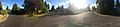
Residential area in Matthews Beach
-
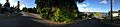
Residential area with a view of Lake Washington
