
Mauston, Wisconsin facts for kids
Quick facts for kids
Mauston, Wisconsin
|
|
|---|---|

Wis-82 & I-90/94 junction
|
|

Location of Mauston in Juneau County, Wisconsin
|
|

Mauston, Wisconsin
Location in Wisconsin

Mauston, Wisconsin
Location in the United States
|
|
| Country | United States |
| State | Wisconsin |
| County | Juneau |
| Government | |
| • Type | Mayor-council government |
| Area | |
| • Total | 4.89 sq mi (12.67 km2) |
| • Land | 4.47 sq mi (11.57 km2) |
| • Water | 0.43 sq mi (1.1 km2) |
| Elevation | 883 ft (269 m) |
| Population
(2020)
|
|
| • Total | 4,347 |
| • Density | 972.5/sq mi (375.5/km2) |
| Time zone | UTC-6 (Central (CST)) |
| • Summer (DST) | UTC-5 (CDT) |
| Zip Code |
53948
|
| Area code(s) | 608 |
| FIPS code | 55-50025 |
| GNIS feature ID | 1569135 |
Mauston is a city in Wisconsin, USA. It's the main city, or county seat, of Juneau County. In 2020, about 4,347 people lived there. Mauston is about 70 miles northwest of Madison, the state capital.
Contents
History of Mauston
Mauston was started by a man named Milton M. Maughs. The town was first called Maughs Town, named after him. Its early days were focused on the lumber industry in Wisconsin. You can learn about Mauston's history at the Boorman House on Union Street.
Geography and Climate
Mauston is located at 43°48′N 90°5′W / 43.800°N 90.083°W. It is in the Central Standard time zone. The city sits about 883 feet above sea level.
Land and Water Areas
The United States Census Bureau says Mauston covers about 4.9 square miles. Most of this area, about 4.47 square miles, is land. The rest, about 0.43 square miles, is water.
Mauston's Weather
| Climate data for Mauston, Wisconsin (1991–2020 normals, extremes 1905–present) | |||||||||||||
|---|---|---|---|---|---|---|---|---|---|---|---|---|---|
| Month | Jan | Feb | Mar | Apr | May | Jun | Jul | Aug | Sep | Oct | Nov | Dec | Year |
| Record high °F (°C) | 56 (13) |
71 (22) |
84 (29) |
91 (33) |
96 (36) |
100 (38) |
103 (39) |
102 (39) |
99 (37) |
90 (32) |
76 (24) |
66 (19) |
103 (39) |
| Mean daily maximum °F (°C) | 26.3 (−3.2) |
31.1 (−0.5) |
43.1 (6.2) |
56.2 (13.4) |
68.5 (20.3) |
77.4 (25.2) |
81.5 (27.5) |
79.8 (26.6) |
72.4 (22.4) |
59.6 (15.3) |
44.5 (6.9) |
31.6 (−0.2) |
56 (13) |
| Daily mean °F (°C) | 17.2 (−8.2) |
21.3 (−5.9) |
33.2 (0.7) |
45.4 (7.4) |
57.5 (14.2) |
66.8 (19.3) |
70.9 (21.6) |
68.8 (20.4) |
61 (16) |
48.7 (9.3) |
35.8 (2.1) |
23.4 (−4.8) |
45.8 (7.7) |
| Mean daily minimum °F (°C) | 8 (−13) |
11.4 (−11.4) |
23.2 (−4.9) |
34.6 (1.4) |
46.6 (8.1) |
56.1 (13.4) |
60.3 (15.7) |
57.9 (14.4) |
49.7 (9.8) |
37.8 (3.2) |
27 (−3) |
15.3 (−9.3) |
35.7 (2.1) |
| Record low °F (°C) | −37 (−38) |
−38 (−39) |
−35 (−37) |
5 (−15) |
18 (−8) |
30 (−1) |
40 (4) |
33 (1) |
20 (−7) |
9 (−13) |
−18 (−28) |
−30 (−34) |
−38 (−39) |
| Average precipitation inches (mm) | 1.34 (34) |
1.25 (32) |
2.01 (51) |
3.73 (95) |
4.51 (115) |
5.11 (130) |
3.83 (97) |
4.47 (114) |
3.75 (95) |
2.69 (68) |
2.01 (51) |
1.63 (41) |
36.33 (923) |
| Average snowfall inches (cm) | 13.1 (33) |
11 (28) |
7.1 (18) |
2.8 (7.1) |
0 (0) |
0 (0) |
0 (0) |
0 (0) |
0 (0) |
0.2 (0.51) |
2.5 (6.4) |
9.9 (25) |
46.6 (118) |
| Average precipitation days (≥ 0.01 in) | 8.3 | 7.4 | 8.2 | 11.2 | 13.1 | 11.6 | 9.8 | 9.8 | 9.6 | 9.6 | 7.7 | 8.9 | 115.2 |
| Average snowy days (≥ 0.1 in) | 6.1 | 5.7 | 3.1 | 1 | 0 | 0 | 0 | 0 | 0 | 0.1 | 1.7 | 4.9 | 22.6 |
| Source: NOAA | |||||||||||||
Getting Around Mauston
Mauston has its own airport, the Mauston-New Lisbon Union Airport (82C). This airport is for general aviation, meaning smaller planes use it. It is shared with the nearby town of New Lisbon. For bigger planes and commercial flights, the closest airports are about an hour away. These are Dane County Regional Airport and La Crosse Regional Airport. You can reach them using Interstate 90.
Major Roads
Two major highways, Interstate 90 and Interstate 94, run together near Mauston. There's an exit at Wisconsin Highway 82. U.S. Route 12 and Wisconsin Highway 16 also pass through downtown Mauston. Wisconsin Highway 58 goes north and south through the town. It crosses over I-90/I-94 but does not have an exit there. WIS-82 goes east and west through town and connects to the interstate exit.
Railroad Connections
Mauston is also served by a railroad line. This line is part of the Canadian Pacific Kansas City Tomah Subdivision. It used to be a main route for the Milwaukee Road between Chicago and Seattle.
Mauston's Population
| Historical population | |||
|---|---|---|---|
| Census | Pop. | %± | |
| 1870 | 952 | — | |
| 1880 | 1,013 | 6.4% | |
| 1890 | 1,343 | 32.6% | |
| 1900 | 1,718 | 27.9% | |
| 1910 | 1,701 | −1.0% | |
| 1920 | 1,966 | 15.6% | |
| 1930 | 2,107 | 7.2% | |
| 1940 | 2,621 | 24.4% | |
| 1950 | 3,171 | 21.0% | |
| 1960 | 3,531 | 11.4% | |
| 1970 | 3,466 | −1.8% | |
| 1980 | 3,284 | −5.3% | |
| 1990 | 3,439 | 4.7% | |
| 2000 | 3,740 | 8.8% | |
| 2010 | 4,423 | 18.3% | |
| 2020 | 4,347 | −1.7% | |
| U.S. Decennial Census | |||
2020 Census Information
In 2020, the population of Mauston was 4,347 people. The city had about 972.5 people per square mile. There were 1,955 homes.
Most people in Mauston were White (89.5%). About 3.6% of the population was Hispanic or Latino. Other groups included Black or African American (2.7%), Native American (1.2%), and Asian (0.8%). Some people identified with two or more races (4.5%).
The average income for a household was $49,730. For families, it was $63,839. About 18.7% of the population lived below the poverty line. This included 14.5% of those under 18 years old. Most adults (89.2%) had finished high school or more. About 15.1% had a college degree.
2010 Census Information
In 2010, Mauston had 4,423 people living in 1,779 households. The population density was about 1007.5 people per square mile.
About 92.8% of the people were White. Other groups included African American (2.6%), Native American (1.2%), and Asian (0.7%). About 3.5% of the population was Hispanic or Latino.
In 29.3% of homes, there were children under 18. About 35.9% of homes had married couples. The average age in the city was 39.3 years.
Schools in Mauston


The Mauston Area School District serves the city and nearby areas. It offers classes from kindergarten through high school. The schools include:
- West Side Elementary (for grades 4K-2)
- Grayside Elementary (for grades 3–5)
- Olson Middle School (for grades 6, 7, and 8)
- Mauston High School (opened in 2001)
There is also Lyndon Station Elementary School in nearby Lyndon Station. It teaches grades K-5.
St. Patrick Parish has run a Catholic school for grades pre-K through 8th since 1895. This school has about 200 students. Mauston also has a campus of Western Technical College.
Media and News
Mauston has its own radio station, WRJC-FM. The local newspaper is the Juneau County Star-Times. Mauston is part of the Madison Television Market. It also gets radio stations from the Wisconsin Dells and Baraboo areas.
Famous People from Mauston
- John T. Benson, a leader in Wisconsin's public education.
- Kelly Bires, a NASCAR driver who also won wrestling championships.
- Thomas John Curran, a judge for the United States Federal Court.
- Kenneth Philip Grubb, another judge for the United States Federal Court.
- Frank H. Hanson, a Wisconsin State Senator and Representative.
- Leo Kieffer, a State Senator in Maine.
- Bill Lobenstein, a player in the NFL.
- Orland Steen Loomis, who was elected as Wisconsin's governor once.
- John Patterson, who received the Medal of Honor.
- Jessica Powers, a Roman Catholic nun and writer.
- Clinton G. Price, a Wisconsin State Representative and lawyer.
- Edwin M. Truell, another recipient of the Medal of Honor.
- Florence E. Ward, an educator and official for the USDA.
Images for kids
-
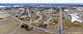
Wis-82 entering on the west side
-
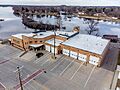
City of Mauston municipal building
-
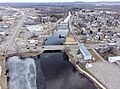
Lemonweir River
-
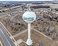
Mauston water tower with cellular tower on top


See also
 In Spanish: Mauston para niños
