Medford, New York facts for kids
Quick facts for kids
Medford, New York
|
|
|---|---|

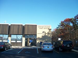
The Medford Post Office in 2013.
|
|

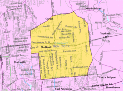
U.S. Census map of Medford.
|
|
| Country | |
| State | |
| County | Suffolk |
| Town | Brookhaven |
| Area | |
| • Total | 10.80 sq mi (27.97 km2) |
| • Land | 10.80 sq mi (27.97 km2) |
| • Water | 0.00 sq mi (0.00 km2) |
| Elevation | 89 ft (27 m) |
| Population
(2020)
|
|
| • Total | 24,247 |
| • Density | 2,245.30/sq mi (866.95/km2) |
| Time zone | UTC−05:00 (Eastern Time Zone) |
| • Summer (DST) | UTC−04:00 |
| ZIP Code |
11763
|
| Area code(s) | 631, 934 |
| FIPS code | 36-46404 |
| GNIS feature ID | 0956903 |
Medford is a small community called a hamlet in New York. It is also a census-designated place, which means it's an area defined by the government for counting people. Medford is located in Suffolk County, on Long Island. In 2020, about 24,247 people lived there.
Contents
Medford's History
The Long Island Rail Road (LIRR) started the Medford station in 1843. This area was a wild, flat land known as the Long Island Central Pine Barrens. The station helped connect Medford to other towns like Patchogue and Port Jefferson. Soon after, a post office was opened.
In 1907, the LIRR created the Medford Prosperity Farm. It was also called Experimental Station #2. This farm was about 80 acres (32 hectares) big. Its goal was to show that crops could grow well in the Pine Barrens. Even Theodore Roosevelt, a former U.S. President, visited the farm in 1910!
Later in the 1900s, new neighborhoods were built in Medford. One of these was Eagle Estates, started in 1963. It included a shopping center and fields for youth baseball. The Long Island Expressway, a major highway, was built through Medford in 1970. This made it easier to travel to and from the area.
Medford's Geography
Medford covers an area of about 28 square kilometers (10.8 square miles). All of this area is land.
Medford's Population
| Historical population | |||
|---|---|---|---|
| Census | Pop. | %± | |
| 2020 | 24,247 | — | |
| U.S. Decennial Census | |||
In 2020, Medford had a population of 24,247 people. Back in 2000, there were 21,985 people living in Medford. Most households were families, with many having children under 18. The average age of people in Medford was about 35 years old.
Education in Medford
Most of Medford is part of the Patchogue-Medford School District. However, small parts of the community are served by the South Country Central School District and the Longwood Central School District.
Media and Radio Stations
Medford is home to two radio stations: W243ES and WLIM. These stations are officially licensed to broadcast from Medford.
Transportation in Medford
Medford has several important roads, including Horseblock Road, New York State Route 112, and the Long Island Expressway.
For public transport, the Long Island Rail Road has a station in Medford. This station has been there since the community began. Suffolk County Transit also provides bus service, connecting Medford to places like Patchogue and Port Jefferson.
Notable People from Medford
- Tricia Cast: An actress known for her roles in soap operas.
- Kevin Connolly: An actor famous for playing "E" in the TV show Entourage. He grew up in Medford.
- Christine Goerke: A talented opera singer.
- Marcus Stroman: A professional baseball pitcher who has played for teams like the New York Yankees and the New York Mets.
- Bryant Neal Vinas: A person known for his involvement with certain groups.
See also
 In Spanish: Medford (Nueva York) para niños
 | Emma Amos |
 | Edward Mitchell Bannister |
 | Larry D. Alexander |
 | Ernie Barnes |


