
Memphis, Missouri facts for kids
Quick facts for kids
Memphis, Missouri
|
|
|---|---|

Town sign
|
|

Location of Memphis, Missouri
|
|
| Country | United States |
| State | Missouri |
| County | Scotland |
| Area | |
| • Total | 1.56 sq mi (4.05 km2) |
| • Land | 1.56 sq mi (4.04 km2) |
| • Water | 0.01 sq mi (0.02 km2) |
| Elevation | 764 ft (233 m) |
| Population
(2020)
|
|
| • Total | 1,731 |
| • Density | 1,111.04/sq mi (428.92/km2) |
| Time zone | UTC-6 (Central (CST)) |
| • Summer (DST) | UTC-5 (CDT) |
| ZIP code |
63555
|
| Area code(s) | 660 |
| FIPS code | 29-47270 |
| GNIS feature ID | 2395092 |
Memphis is a city in Scotland County, Missouri. It is the main city, also known as the county seat, of Scotland County. Memphis is located on the northern border of Missouri, in the United States. In 2020, about 1,731 people lived here. U.S. Highway 136 goes near Memphis. The city is east of Lancaster and west of Kahoka.
Contents
History of Memphis


Scotland County was created on January 29, 1841. However, the town of Memphis was started more than two years later. On May 15, 1843, county leaders met to choose a main city for the county. They picked a spot in the middle of the county. After some discussion, they named it Memphis, like the famous city in Memphis, Egypt. This name was already used by a nearby post office.
An early settler named Samuel Cecil gave about 50 acres of land for the new town. The first map of Memphis was officially recorded on October 11, 1843. Some homes were already in the area. The very first home was a log cabin built in 1835 by Burton Tompkins.
Scotland County's first courthouse was finished in June 1845. It was a two-story brick building and cost $1,500. Ten years later, the county leaders said the building was not safe. A second, bigger courthouse was built in 1856. It cost $19,500 and was in the middle of the town square. This building was used until the early 1900s. It was 40 by 70 feet, which became too small. In May 1905, it was declared unsafe and torn down in 1907. The current Scotland County courthouse was built between October 1907 and July 1908. It cost $50,000.
Memphis During the Civil War
Scotland County saw some important events during the American Civil War. On July 13, 1862, a group of Confederate soldiers, led by Colonel Joseph C. Porter, came to Memphis. They captured the city easily. First, they took weapons from the federal armory. They got about 100 muskets, ammunition, and some uniforms.
The soldiers gathered all the adult men and took them to the courthouse. The men had to promise not to tell anyone about the soldiers for two days. Colonel Porter let any local soldiers go, waiting for them to be officially released. He also let a doctor, who supported the Union, go home because his wife was very sick. Porter's troops went into the courthouse and destroyed records about horse theft. This action has different meanings to different people.
Memphis in the 1900s
In the late 1920s, a company called The Pheasant Aircraft Company started in Memphis. This company built airplanes.
Geography of Memphis
Memphis is located along the North Fabius River. The city covers an area of about 1.57 square miles (4.05 square kilometers). Most of this area, about 1.56 square miles (4.04 square kilometers), is land. A small part, about 0.01 square miles (0.02 square kilometers), is water.
Memphis Climate
| Climate data for Memphis, Missouri (1991–2020 normals, extremes 1938–present) | |||||||||||||
|---|---|---|---|---|---|---|---|---|---|---|---|---|---|
| Month | Jan | Feb | Mar | Apr | May | Jun | Jul | Aug | Sep | Oct | Nov | Dec | Year |
| Record high °F (°C) | 70 (21) |
77 (25) |
85 (29) |
91 (33) |
99 (37) |
102 (39) |
106 (41) |
105 (41) |
103 (39) |
98 (37) |
88 (31) |
71 (22) |
106 (41) |
| Mean daily maximum °F (°C) | 32.5 (0.3) |
37.5 (3.1) |
49.8 (9.9) |
62.2 (16.8) |
72.1 (22.3) |
81.8 (27.7) |
85.8 (29.9) |
84.3 (29.1) |
77.3 (25.2) |
64.6 (18.1) |
49.8 (9.9) |
37.7 (3.2) |
61.3 (16.3) |
| Daily mean °F (°C) | 23.1 (−4.9) |
27.5 (−2.5) |
39.2 (4.0) |
50.6 (10.3) |
61.3 (16.3) |
71.0 (21.7) |
75.1 (23.9) |
73.2 (22.9) |
65.2 (18.4) |
53.1 (11.7) |
39.5 (4.2) |
28.9 (−1.7) |
50.6 (10.3) |
| Mean daily minimum °F (°C) | 13.8 (−10.1) |
17.6 (−8.0) |
28.6 (−1.9) |
39.0 (3.9) |
50.5 (10.3) |
60.2 (15.7) |
64.4 (18.0) |
62.1 (16.7) |
53.2 (11.8) |
41.6 (5.3) |
29.3 (−1.5) |
20.0 (−6.7) |
40.0 (4.4) |
| Record low °F (°C) | −24 (−31) |
−23 (−31) |
−13 (−25) |
6 (−14) |
25 (−4) |
35 (2) |
42 (6) |
40 (4) |
25 (−4) |
15 (−9) |
−13 (−25) |
−23 (−31) |
−24 (−31) |
| Average precipitation inches (mm) | 1.51 (38) |
1.47 (37) |
2.15 (55) |
3.65 (93) |
5.48 (139) |
4.71 (120) |
4.30 (109) |
3.78 (96) |
3.57 (91) |
2.98 (76) |
2.16 (55) |
1.58 (40) |
37.34 (948) |
| Average snowfall inches (cm) | 6.6 (17) |
6.8 (17) |
1.2 (3.0) |
0.4 (1.0) |
0.0 (0.0) |
0.0 (0.0) |
0.0 (0.0) |
0.0 (0.0) |
0.0 (0.0) |
0.2 (0.51) |
0.7 (1.8) |
3.4 (8.6) |
19.3 (49) |
| Average precipitation days (≥ 0.01 in) | 5.0 | 5.4 | 6.9 | 8.5 | 10.0 | 8.8 | 7.2 | 6.7 | 6.2 | 6.6 | 5.5 | 5.5 | 82.3 |
| Average snowy days (≥ 0.1 in) | 2.5 | 2.4 | 0.7 | 0.1 | 0.0 | 0.0 | 0.0 | 0.0 | 0.0 | 0.1 | 0.4 | 2.3 | 8.5 |
| Source: NOAA | |||||||||||||
Memphis Population Data
| Historical population | |||
|---|---|---|---|
| Census | Pop. | %± | |
| 1850 | 183 | — | |
| 1870 | 1,007 | — | |
| 1880 | 1,418 | 40.8% | |
| 1890 | 1,780 | 25.5% | |
| 1900 | 2,195 | 23.3% | |
| 1910 | 1,984 | −9.6% | |
| 1920 | 1,941 | −2.2% | |
| 1930 | 1,728 | −11.0% | |
| 1940 | 1,935 | 12.0% | |
| 1950 | 2,035 | 5.2% | |
| 1960 | 2,106 | 3.5% | |
| 1970 | 2,081 | −1.2% | |
| 1980 | 2,105 | 1.2% | |
| 1990 | 2,094 | −0.5% | |
| 2000 | 2,061 | −1.6% | |
| 2010 | 1,822 | −11.6% | |
| 2020 | 1,731 | −5.0% | |
| U.S. Decennial Census | |||
2010 Census Information
In 2010, the census showed that 1,822 people lived in Memphis. There were 813 households, which are groups of people living together. The city had about 1,168 people per square mile.
About 24% of the people living in Memphis were under 18 years old. About 23.3% were 65 years old or older. The average age in the city was 43.8 years.
Education in Memphis
The public schools in Memphis are managed by the Scotland County R-I School District.
Memphis also has the Scotland County Memorial Library. This library serves everyone in the city and the entire county.
Famous People from Memphis
- Alexandre Hogue: A painter known for his realistic landscapes.
- Tom Horn: A scout during the Apache Wars and a famous gunfighter.
- George Saling: An athlete who won a gold medal in track and field at the 1932 Summer Olympics.
- Adrienne Wilkinson: An actress known for her roles in TV shows like Xena: Warrior Princess.
Gallery
-
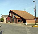
North side of the Memphis square. September, 2012.
-
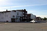
East side of the Memphis square. September, 2012.
-
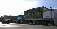
South side of the Memphis square. September, 2012.
-
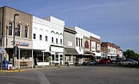
West side of the Memphis square. September, 2012.


See also
 In Spanish: Memphis (Misuri) para niños
