Menlo, Georgia facts for kids
Quick facts for kids
Menlo, Georgia
|
|
|---|---|

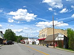
Buildings along 7th Avenue (SR 337)
|
|

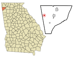
Location in Chattooga County and the state of Georgia
|
|
| Country | United States |
| State | Georgia |
| County | Chattooga |
| Area | |
| • Total | 0.78 sq mi (2.03 km2) |
| • Land | 0.78 sq mi (2.03 km2) |
| • Water | 0.00 sq mi (0.00 km2) |
| Elevation | 1,100 ft (335 m) |
| Population
(2020)
|
|
| • Total | 480 |
| • Density | 613.03/sq mi (236.68/km2) |
| Time zone | UTC-5 (Eastern (EST)) |
| • Summer (DST) | UTC-4 (EDT) |
| ZIP code |
30731
|
| Area code(s) | 706/762 |
| FIPS code | 13-50848 |
| GNIS feature ID | 0332373 |
Menlo is a small city located in Chattooga County, Georgia, in the United States. In 2020, about 480 people lived there. It's a quiet place with a rich history.
History of Menlo
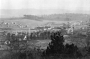
Menlo was first planned out in 1883. A post office, where people could send and receive mail, opened in Menlo in 1886. The state government of Georgia officially made Menlo a town in 1903.
The person who founded the city, Captain Andrew Lawrence, chose the name Menlo. He named it after Menlo Park, New Jersey. This was done to honor the famous inventor Thomas Edison, who had a laboratory in Menlo Park, New Jersey.
Geography of Menlo
Menlo is found at the bottom of the Cumberland Plateau, which is a large, flat-topped mountain area. It's located in the western part of Chattooga County, Georgia. The city is just a little over a mile away from the border with Alabama.
Several roads help people travel to and from Menlo. Georgia State Route 48 goes right through the middle of the city. If you go east on this road, you'll reach Summerville, which is the main town of Chattooga County, about 8 miles away. If you go northwest for about 3 miles, you'll get to Cloudland, which is on top of Lookout Mountain. Another road, SR 337, heads northeast through a place called Broomtown Valley and leads to LaFayette, about 20 miles away.
The city of Menlo covers a total area of about 2.0 square kilometers (or 0.78 square miles). All of this area is land, with no large bodies of water inside the city limits.
Menlo's Population
| Historical population | |||
|---|---|---|---|
| Census | Pop. | %± | |
| 1910 | 376 | — | |
| 1920 | 378 | 0.5% | |
| 1930 | 355 | −6.1% | |
| 1940 | 414 | 16.6% | |
| 1950 | 453 | 9.4% | |
| 1960 | 466 | 2.9% | |
| 1970 | 593 | 27.3% | |
| 1980 | 611 | 3.0% | |
| 1990 | 538 | −11.9% | |
| 2000 | 485 | −9.9% | |
| 2010 | 474 | −2.3% | |
| 2020 | 480 | 1.3% | |
| U.S. Decennial Census | |||
According to the census taken in 2000, there were 485 people living in Menlo. These people lived in 229 different homes, and 141 of these were families.
Most of the people living in Menlo were White (about 96.5%). A smaller number were African American (about 3.3%), and a very small percentage were from two or more different racial backgrounds. About 0.4% of the population identified as Hispanic or Latino.
In terms of age, the population was spread out. About 20% of the people were under 18 years old. Around 24% were 65 years old or older. The average age in Menlo was 44 years old.
The average income for a household in Menlo was $23,750 per year in 2000. For families, the average income was $32,143. Some families and individuals in Menlo had lower incomes.
Commerce in Menlo
Menlo does not have many large businesses or stores. The biggest business in the city is Best Glove, Inc. This company makes and supplies gloves for medical and industrial uses.
See also
 In Spanish: Menlo (Georgia) para niños
 | Sharif Bey |
 | Hale Woodruff |
 | Richmond Barthé |
 | Purvis Young |


