Mill Hill (Derbyshire) facts for kids
Quick facts for kids Mill Hill |
|
|---|---|

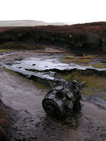
Wreckage of the Liberator bomber on Mill Hill
|
|
| Highest point | |
| Elevation | 544 m (1,785 ft) |
| Prominence | 32 m |
| Parent peak | Kinder Scout |
| Listing | TuMP |
| Geography | |
| Location | Derbyshire, England, UK |
| Parent range | Peak District |
| OS grid | SK061904 |
| Topo map | OS Landranger 110; OL1W |
Mill Hill is a cool, flat-topped hill in the Peak District of England. It stands tall at 544 metres (1,785 ft) high in the county of Derbyshire. It's a great spot for hiking and exploring the outdoors!
Where is Mill Hill?
Mill Hill is located in the beautiful Peak District hills. It's about 4 kilometres (2.5 mi) southeast of the town of Glossop. It's also a similar distance northwest of Kinder Scout, which is the highest point in the Peak District.
What Does Mill Hill Look Like?
Mill Hill has a bare, rounded top covered in peat moorland. A moorland is a type of open, uncultivated land, often covered with heather. You'll find a small pile of stones called a cairn and a marker pole at the very top. Over time, many visitors have walked on the summit, which has caused some erosion. Because of this, the highest point is now actually a little bit to the northeast.
This hill is also part of the famous Pennine Way walking trail. This trail stretches for hundreds of miles across England, and Mill Hill is one of the interesting spots along the way.
Plane Crash Site
Mill Hill is known for a plane crash that happened there during World War II. On October 11, 1944, a Liberator bomber crashed on the hill. This plane belonged to the US 310th Ferry Squadron.
The aircraft was being moved from one air base, RAF Burtonwood, to another, RAF Hardwick. After taking off, the plane had some problems but managed to climb to about 2,800 feet. However, it flew into thick clouds and hit the ground. Luckily, the two crew members, 2nd Lt Creighton R Houpt and SSgt Jerome M Najvar, survived the crash!
 | Isaac Myers |
 | D. Hamilton Jackson |
 | A. Philip Randolph |

