Minamisanriku facts for kids
Quick facts for kids
Minamisanriku
南三陸町
|
|||
|---|---|---|---|
|
Town
|
|||

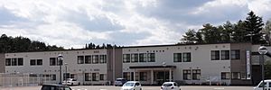
Minamisanriku Town Hall, May 2013
|
|||
|
|||

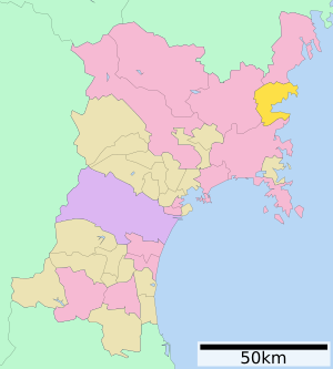
Location of Minamisanriku in Miyagi Prefecture
|
|||
| Country | Japan | ||
| Region | Tōhoku | ||
| Prefecture | Miyagi | ||
| District | Motoyoshi | ||
| Area | |||
| • Total | 163.40 km2 (63.09 sq mi) | ||
| Population
(October 10, 2020)
|
|||
| • Total | 12,225 | ||
| • Density | 74.816/km2 (193.774/sq mi) | ||
| Time zone | UTC+09:00 (Japan Standard Time) | ||
| - Tree | Persera thunbergii | ||
| - Flower | Azalea | ||
| - Bird | Golden eagle | ||
| - Fish | Common octopus | ||
| - Color | sky blue | ||
| Address | 77 Shioiri, Shizugawa, Minamisanriku-cho, Motoyoshi-gun Miyagi-ken 986-0792 | ||
| Climate | Cfa | ||
Minamisanriku (南三陸町, Minamisanriku-chō) is a town located in Miyagi Prefecture, Japan. As of May 1, 2020, about 12,516 people lived there in 4,504 homes. The town covers an area of 163.40 square kilometers (63.09 sq mi). It is a popular place for tourists, known for its beautiful coastline with many wooded islands and mountain inlets. Sadly, large parts of the town were badly damaged by the huge 2011 Tōhoku earthquake and tsunami.
Contents
Exploring Minamisanriku's Geography
Minamisanriku is located in the far northeastern part of Miyagi Prefecture. Its coastline is part of the Sanriku Fukkō National Park. This park is a special protected area that stretches all the way north to Aomori Prefecture.
Mountains and Forests in Minamisanriku
The town is surrounded by the Kitakami Mountains on its north, west, and south sides. These mountains make the area very scenic. About 70% of Minamisanriku is covered in forests. This means there are lots of trees and natural beauty to explore.
Understanding Minamisanriku's Climate
Minamisanriku has a humid subtropical climate. This means it has warm, wet summers and cold winters. The average temperature each year is around 11.4°C (52.5°F). The town gets about 1302.3 mm (51.27 in) of rain each year, with September being the wettest month. The warmest month is usually August, with temperatures around 23.0°C (73.4°F). January is the coldest, with temperatures around 0.7°C (33.3°F).
| Climate data for Shizugawa, Minamisanriku (1991−2020 normals, extremes 1976−present) | |||||||||||||
|---|---|---|---|---|---|---|---|---|---|---|---|---|---|
| Month | Jan | Feb | Mar | Apr | May | Jun | Jul | Aug | Sep | Oct | Nov | Dec | Year |
| Record high °C (°F) | 16.2 (61.2) |
19.6 (67.3) |
23.8 (74.8) |
30.2 (86.4) |
33.5 (92.3) |
34.2 (93.6) |
36.3 (97.3) |
38.0 (100.4) |
35.0 (95.0) |
28.7 (83.7) |
23.5 (74.3) |
20.5 (68.9) |
38.0 (100.4) |
| Mean daily maximum °C (°F) | 5.4 (41.7) |
6.3 (43.3) |
9.8 (49.6) |
15.1 (59.2) |
19.4 (66.9) |
22.1 (71.8) |
25.5 (77.9) |
27.3 (81.1) |
24.2 (75.6) |
19.3 (66.7) |
13.8 (56.8) |
7.9 (46.2) |
16.3 (61.4) |
| Daily mean °C (°F) | 0.7 (33.3) |
1.2 (34.2) |
4.2 (39.6) |
9.2 (48.6) |
14.0 (57.2) |
17.5 (63.5) |
21.4 (70.5) |
23.0 (73.4) |
19.8 (67.6) |
14.2 (57.6) |
8.4 (47.1) |
3.1 (37.6) |
11.4 (52.5) |
| Mean daily minimum °C (°F) | −3.1 (26.4) |
−3.0 (26.6) |
−0.6 (30.9) |
3.8 (38.8) |
9.2 (48.6) |
13.8 (56.8) |
18.3 (64.9) |
19.8 (67.6) |
16.2 (61.2) |
9.8 (49.6) |
3.5 (38.3) |
−0.9 (30.4) |
7.2 (45.0) |
| Record low °C (°F) | −12.3 (9.9) |
−12.5 (9.5) |
−8.1 (17.4) |
−4.4 (24.1) |
0.2 (32.4) |
4.5 (40.1) |
9.5 (49.1) |
12.5 (54.5) |
6.7 (44.1) |
−0.5 (31.1) |
−4.7 (23.5) |
−9.6 (14.7) |
−12.5 (9.5) |
| Average precipitation mm (inches) | 45.3 (1.78) |
39.2 (1.54) |
88.6 (3.49) |
103.3 (4.07) |
116.7 (4.59) |
130.7 (5.15) |
167.3 (6.59) |
142.8 (5.62) |
184.2 (7.25) |
155.3 (6.11) |
70.7 (2.78) |
54.2 (2.13) |
1,302.3 (51.27) |
| Average precipitation days (≥ 1.0 mm) | 6.1 | 6.2 | 8.4 | 9.0 | 10.2 | 11.0 | 13.1 | 11.1 | 11.3 | 9.0 | 7.5 | 7.1 | 110 |
| Mean monthly sunshine hours | 171.9 | 171.4 | 192.3 | 199.5 | 199.7 | 157.9 | 139.9 | 161.1 | 137.9 | 155.6 | 158.6 | 153.4 | 1,997.1 |
| Source: Japan Meteorological Agency | |||||||||||||
Nearby Towns and Cities
Minamisanriku shares borders with a few other places in Miyagi Prefecture:
- Kesennuma
- Tome
- Ishinomaki
Minamisanriku's Population Changes
The number of people living in Minamisanriku reached its highest point in the 1950s. Since then, the population has slowly decreased over the last 70 years.
| Historical population | ||
|---|---|---|
| Year | Pop. | ±% |
| 1920 | 17,054 | — |
| 1930 | 18,410 | +8.0% |
| 1940 | 19,496 | +5.9% |
| 1950 | 25,168 | +29.1% |
| 1960 | 24,852 | −1.3% |
| 1970 | 22,943 | −7.7% |
| 1980 | 22,243 | −3.1% |
| 1990 | 21,401 | −3.8% |
| 2000 | 19,860 | −7.2% |
| 2010 | 17,429 | −12.2% |
| 2020 | 12,225 | −29.9% |
A Look at Minamisanriku's History
The area where Minamisanriku is today was once part of an old Japanese province called Mutsu Province. During the Edo period, a powerful family called the Date clan from Sendai Domain controlled this region. This was when the Tokugawa shogunate ruled Japan.
Tsunami History in Minamisanriku
Minamisanriku has a long history of dealing with tsunamis, which are giant ocean waves.
- In 869, a large earthquake called the 869 Sanriku earthquake caused a tsunami.
- Later, in 1896, the 1896 Sanriku earthquake created a huge tsunami wave. It was 38.2 meters (125.3 ft) high, which was the tallest ever recorded in Japan at that time.
- In 1933, another tsunami hit during the 1933 Sanriku earthquake.
- The 2011 tsunami, however, was even bigger. It created a wave 40.4 meters (132.5 ft) high in Miyako, which was higher than the 1896 record.
How Minamisanriku Was Formed
The modern town of Minamisanriku was created on October 1, 2005. It was formed by combining two smaller towns: Shizugawa and Utatsu. Both of these towns were part of Motoyoshi District. Before that, Shizugawa became a town in 1895, and Utatsu became a town in 1959.
Learning from Past Tsunamis
In 1960, a huge earthquake in Chile, called the 1960 Valdivia earthquake, caused a tsunami that traveled across the Pacific Ocean. This tsunami hit Shizugawa with waves up to 2.8 meters (9.2 ft) high, causing a lot of damage. After this, two-story-high harbor walls were built by 1963 to protect the town. Residents also started practicing tsunami drills every year to be prepared. In 1990, a special plaque and a replica of a moai statue from Chile were placed in the town to remember the disaster and the friendship between the two countries.
Sadly, these harbor walls were not strong enough for the 2011 tsunami, which was so powerful it went over four-story buildings. In 2010, another earthquake in Chile caused a smaller 1.3-meter (4.3 ft) tsunami in Minamisanriku.
The 2011 Earthquake and Tsunami Disaster
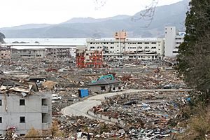
The 2011 Japanese tsunami, which followed the 2011 Tōhoku earthquake, caused terrible destruction in Minamisanriku. Reports said that 95% of the town was destroyed. Only the very tallest buildings were left standing. For days after the disaster, about half of the town's population was missing. In the first week, only 9,700 people were confirmed alive and had been moved to safety. By late June 2011, 1,206 people were confirmed dead or missing.
The town had two places where people could go to be safe from a tsunami, called evacuation centers. Even though both were 20 meters (66 ft) above sea level, the tsunami waves were so big that they covered these centers and swept people away. At least 31 of the town's 80 special evacuation spots were flooded by the tsunami. The tsunami waves in Minamisanriku were about 13.7 meters (45 ft) high on average. The highest wave recorded was 20.5 meters (67.3 ft) just southwest of the town center.
An English teacher at the high school, which was on a hill above the tsunami, said that the "entire town was simply swept away. It just no longer exists." Many children became orphans because their parents were lost in the tsunami. Survivors wrote "SOS" in large white letters on the playing field of Shizugawa High School to signal for help.
When the earthquake hit, the mayor, Jin Sato, was at a town meeting. The three-story building of the town's Crisis Management Department, where Mayor Sato went for safety, was completely covered by the tsunami. Out of 130 people who worked at the town hall, 53 made it to the roof, but only 10 survived. Mayor Sato was one of them. He quickly started working again, setting up a new disaster control center on March 13, 2011.
Shizugawa Hospital was one of the few big buildings that survived the tsunami. It was partly flooded, and 74 out of 109 patients died. Nearly 200 people were rescued from the hospital's roof.
Miki Endo, a 25-year-old woman who worked for the town's Crisis Management Department, became a hero in Japan. She kept broadcasting warnings and alerts over the town's loudspeaker system, even as the tsunami flooded her building. Many people believe she saved many lives by doing this. The three-story building where she worked was completely destroyed inside, with only a red steel frame left. Miki Endo was missing after the disaster and was later confirmed to have died. Photos show the building's roof completely underwater at the peak of the tsunami, with some people holding onto the rooftop antenna.
The remaining steel frame of the building, with its bent parts, has been kept as a reminder of the damage. A new sea wall is being built in Minamisanriku to help protect the town in the future. Other important places, like the town's seafood market, have also been rebuilt. The market was one of the first places to reopen, first in a temporary tent. Since much of the town's fishing boats were damaged or lost, people worked together, sharing supplies and boats to help the fishing industry start again.
Minamisanriku's Economy
Minamisanriku's economy mainly depends on two things: tourism and commercial fishing. Many people visit the town for its beauty, and fishing is a very important job for the local people.
Education in Minamisanriku
Minamisanriku has several schools for children and teenagers:
- Five public elementary schools
- Two public middle schools
- One public high school, which is run by the Miyagi Prefectural Board of Education.
Getting Around Minamisanriku
Train Travel
![]() East Japan Railway Company (JR East) - Kesennuma Line (This train service is currently stopped and replaced by a bus service called BRT.)
East Japan Railway Company (JR East) - Kesennuma Line (This train service is currently stopped and replaced by a bus service called BRT.)
- Rikuzen-Togura - Shizugawa -Shizuhama - Utatsu - Rikuzen-Minato - Kurauchi
Highways
You can reach Minamisanriku by these major roads:
 Sanriku Expressway
 National Route 45
 National Route 398
Fun Places to Visit in Minamisanriku
- Mount Tatsugane
- Tubakishima (a special island that is a National Natural Monument)
- Daio-ji, a Buddhist temple
Friendship Cities
Minamisanriku has special friendships with other cities around the world:
 Besano, Lombardy, Italy (since November 7, 1999)
 Shōnai, Yamagata, Japan (since October 13, 1999)
See also
 In Spanish: Minamisanriku para niños
 | Stephanie Wilson |
 | Charles Bolden |
 | Ronald McNair |
 | Frederick D. Gregory |


