Miyako, Iwate facts for kids
Quick facts for kids
Miyako
宮古市
|
|||
|---|---|---|---|

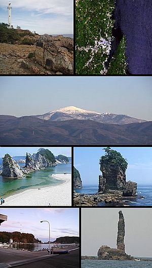
Top left: Cape Todo and lighthouse, Top right: Miyako Bay from satellite, 2nd row: Mount Hayachine, lower left: Jyodo Beach, lower right: Sano Rock, Bottom left: Tago Port, Bottom right: Rosoku (Candle)
|
|||
|
|||
 |
|||
| Country | Japan | ||
| Region | Tōhoku | ||
| Prefecture | Iwate | ||
| Area | |||
| • Total | 1,259.15 km2 (486.16 sq mi) | ||
| Population
(April 1, 2020)
|
|||
| • Total | 51,150 | ||
| • Density | 40.623/km2 (105.212/sq mi) | ||
| Time zone | UTC+09:00 (Japan Standard Time) | ||
| City symbols | |||
| - Tree | Japanese red pine | ||
| - Flower | Montauk daisy (Nipponanthemum nipponicum) | ||
| - Bird | Black-tailed gull | ||
| - Fish | Chum salmon | ||
| Phone number | 0193-62-2111 | ||
| Address | 2-1 Shinkawachō, Miyako-shi, Iwate-ken 027-8501 | ||
Miyako (宮古市, Miyako-shi) is a city located in Iwate Prefecture, Japan. As of April 1, 2020, about 51,150 people lived there. The city covers an area of 1259.15 square kilometers.
Contents
Geography of Miyako
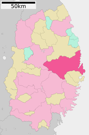
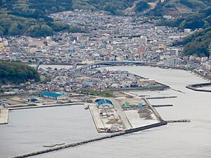
Miyako is in the middle of Iwate Prefecture. It faces the Pacific Ocean to the east. The main part of the city is on Miyako Bay. It's at the northern end of the rias coast, which means it has a coastline with many narrow inlets. Miyako is east of Morioka, the capital of the prefecture.
Miyako is the largest city in Iwate Prefecture by area. It's also the second largest in the Tōhoku region. However, about 90% of the city is covered by mountains and forests. This means only about 9% of the land can be lived on. Even though the overall population density is low, the density in the areas where people live is higher than the average for the prefecture.
A train line and a highway connect Miyako to Morioka. There's also a coastal highway that runs through the town. Miyako has a small port. Parts of the city's coast are in the Sanriku Fukkō National Park. Some of the mountains are in Hayachine Quasi-National Park. The easternmost point of Honshu island, called Cape Todo (魹ヶ崎, Todogasaki), is in Miyako.
Neighboring Towns and Cities
Miyako shares borders with these places in Iwate Prefecture:
Miyako's Climate
Miyako has a climate that is a mix of humid subtropical and oceanic. This means it has mild summers and cold winters. The average temperature in Miyako is about 10.9 degrees Celsius. The city gets about 1282 millimeters of rain each year. September is usually the wettest month, and February is the driest. August is the warmest month, with temperatures around 22.1 degrees Celsius. January is the coldest, with temperatures around 0.5 degrees Celsius.
| Climate data for Miyako, 1991–2020 normals, extremes 1872–present | |||||||||||||
|---|---|---|---|---|---|---|---|---|---|---|---|---|---|
| Month | Jan | Feb | Mar | Apr | May | Jun | Jul | Aug | Sep | Oct | Nov | Dec | Year |
| Record high °C (°F) | 18.9 (66.0) |
21.3 (70.3) |
24.2 (75.6) |
32.1 (89.8) |
32.9 (91.2) |
35.9 (96.6) |
37.4 (99.3) |
37.2 (99.0) |
34.6 (94.3) |
30.0 (86.0) |
26.9 (80.4) |
23.2 (73.8) |
37.4 (99.3) |
| Mean daily maximum °C (°F) | 5.2 (41.4) |
5.6 (42.1) |
9.1 (48.4) |
14.6 (58.3) |
18.9 (66.0) |
21.0 (69.8) |
24.4 (75.9) |
26.3 (79.3) |
23.5 (74.3) |
18.8 (65.8) |
13.5 (56.3) |
7.7 (45.9) |
15.7 (60.3) |
| Daily mean °C (°F) | 0.5 (32.9) |
0.8 (33.4) |
3.9 (39.0) |
8.9 (48.0) |
13.5 (56.3) |
16.5 (61.7) |
20.3 (68.5) |
22.1 (71.8) |
19.1 (66.4) |
13.6 (56.5) |
8.1 (46.6) |
2.9 (37.2) |
10.8 (51.4) |
| Mean daily minimum °C (°F) | −3.5 (25.7) |
−3.5 (25.7) |
−0.8 (30.6) |
3.9 (39.0) |
9.0 (48.2) |
13.1 (55.6) |
17.4 (63.3) |
19.2 (66.6) |
15.6 (60.1) |
9.2 (48.6) |
3.0 (37.4) |
−1.4 (29.5) |
6.8 (44.2) |
| Record low °C (°F) | −17.3 (0.9) |
−15.1 (4.8) |
−14.6 (5.7) |
−7.3 (18.9) |
−1.5 (29.3) |
1.6 (34.9) |
4.9 (40.8) |
9.6 (49.3) |
3.7 (38.7) |
−2.9 (26.8) |
−7.0 (19.4) |
−13.4 (7.9) |
−17.3 (0.9) |
| Average precipitation mm (inches) | 63.4 (2.50) |
54.7 (2.15) |
87.5 (3.44) |
91.9 (3.62) |
98.1 (3.86) |
123.4 (4.86) |
157.5 (6.20) |
177.9 (7.00) |
216.4 (8.52) |
166.1 (6.54) |
62.8 (2.47) |
67.6 (2.66) |
1,370.9 (53.97) |
| Average snowfall cm (inches) | 20 (7.9) |
33 (13) |
28 (11) |
2 (0.8) |
0 (0) |
0 (0) |
0 (0) |
0 (0) |
0 (0) |
0 (0) |
0 (0) |
9 (3.5) |
91 (36) |
| Average precipitation days (≥ 0.5 mm) | 5.4 | 6.0 | 8.2 | 9.2 | 10.6 | 11.1 | 13.6 | 12.4 | 12.1 | 9.0 | 6.4 | 5.5 | 109.4 |
| Average relative humidity (%) | 60 | 62 | 63 | 66 | 74 | 84 | 88 | 87 | 85 | 78 | 69 | 63 | 73 |
| Mean monthly sunshine hours | 158.4 | 153.2 | 179.7 | 186.6 | 185.0 | 152.6 | 133.9 | 153.2 | 133.8 | 149.6 | 146.8 | 147.6 | 1,876.2 |
| Source: Japan Meteorological Agency | |||||||||||||
Population Changes in Miyako
The number of people living in Miyako reached its highest point around 1960. Since then, the population has slowly gone down over the last 60 years.
| Historical population | ||
|---|---|---|
| Year | Pop. | ±% |
| 1920 | 44,635 | — |
| 1930 | 53,366 | +19.6% |
| 1940 | 70,318 | +31.8% |
| 1950 | 55,744 | −20.7% |
| 1960 | 81,093 | +45.5% |
| 1970 | 79,805 | −1.6% |
| 1980 | 78,617 | −1.5% |
| 1990 | 72,538 | −7.7% |
| 2000 | 66,986 | −7.7% |
| 2010 | 59,442 | −11.3% |
| 2020 | 50,369 | −15.3% |
History of Miyako
The area where Miyako is today was once part of an old province called Mutsu Province. People have lived here since at least the Jōmon period, which was a very long time ago. The Emishi people lived here, and later, the imperial family took control. They built a strong settlement on the coast during the early Heian period.
During the Muromachi period, the Nambu clan ruled this area. Miyako became an important seaport for the Morioka Domain during the Edo period, when the Tokugawa shogunate was in power.
On January 27, 1700, a 3-meter-tall tsunami hit Miyako's coast. This tsunami was caused by a huge earthquake far away in Cascadia (North America). It destroyed 20 homes. Records from Miyako helped scientists figure out the exact date of that distant earthquake.
During the Meiji restoration, a big change in Japan's government, the Battle of Miyako Bay was an important naval battle that happened here.
In the Meiji period, modern towns were created. Miyako and Kuwagasaki were two of them. In 1896, a huge 18.9-meter-tall tsunami hit the area, killing 1,859 people. Miyako and Kuwagasaki joined together in 1924. On March 3, 1933, another tsunami destroyed most of the town, killing 911 people and ruining over 98% of the buildings. Miyako officially became a city on June 20, 1940.
Over time, Miyako grew by combining with nearby towns and villages. On June 6, 2005, Miyako absorbed the town of Tarō and the village of Niisato, which more than doubled its size. On January 1, 2010, Miyako also absorbed the village of Kawai.
2011 Tōhoku Earthquake and Tsunami
On March 11, 2011, Miyako was severely affected by a tsunami caused by the 2011 Tōhoku earthquake. The city's fishing fleet had 960 ships, but only about 30 to 60 of them survived.
Scientists from the University of Tokyo studied the area. They found that the tsunami waters reached at least 37.9 meters (about 124 feet) above sea level in some places. This was almost as high as the record set by the 1896 tsunami. The disaster resulted in 420 confirmed deaths and 92 people missing. About 4,005 buildings in Miyako were destroyed.
Some of the most well-known videos of the tsunami were filmed in Miyako. These videos showed a dark wave rising over a floodwall and carrying away cars. They also showed a fishing ship flipping over as it hit the underwater floodwall and then being crushed under a bridge.
Miyako's Economy
The main parts of Miyako's economy are commercial fishing and processing food from the sea.
Education in Miyako
Colleges
- Miyako Junior College
Schools
Miyako has 21 public elementary schools and 11 public junior high schools. These are run by the city government. The city also has five public high schools, which are run by the Iwate Prefectural Board of Education. There is also one private high school. Additionally, Iwate Prefecture operates a special education school for students with disabilities.
Transportation
Railway
![]() East Japan Railway Company (JR East) - Yamada Line
East Japan Railway Company (JR East) - Yamada Line
- Kuzakai - Matsukusa - Hiratsuto - Kawauchi - Hakoishi - Rikuchū-Kawai - Haratai - Moichi - Hikime - Kebaraichi - Sentoku - Miyako
Sanriku Railway – Rias Line
- Haraigawa - Sokei - Yagisawa Miyakotandai - Tsugaruishi - Miyako - Yamaguchi Danchi - Ichinowatari - Sabane - Tarō - Settai
Highways
 Sanriku Expressway
 Sanriku-kita Jūkan Road
 National Route 45
 National Route 106
 National Route 340
Port
- Port of Miyako
Places to Visit in Miyako
- Cape Todo
- Jōdogahama, a beautiful scenic spot
- Mount Hayachine, one of Japan's 100 Famous Japanese Mountains
- Sakiyama Shell Mound, an ancient site from the Jōmon period
- Sanriku Fukkō National Park
International Connections
Miyako has friendly relationships with these cities:
 Yantai, Shandong province, China (since April 1, 1966)
 La Trinidad, Benguet, Philippines (since August 7, 1992)
Famous People from Miyako
- Toshio Fujiwara, a kick-boxer
- Nobutoshi Hikage, a judoka (judo athlete)
- Mirai Maiumi, a professional wrestler
- Tokuichiro Tamazawa, a politician
Miyako in Movies
Miyako was a place where the movie Times of Joy and Sorrow was filmed in 1957. The movie starred Hideko Takamine and Keiji Sada.
See also
 In Spanish: Miyako (Iwate) para niños
 | Georgia Louise Harris Brown |
 | Julian Abele |
 | Norma Merrick Sklarek |
 | William Sidney Pittman |


