
Morioka facts for kids
Quick facts for kids
Morioka
盛岡市
|
|||
|---|---|---|---|

Morioka City Montage
|
|||
|
|||
 |
|||

Morioka
Location in Japan
|
|||
| Country | Japan | ||
| Region | Tōhoku | ||
| Prefecture | Iwate | ||
| First official recorded | 4th century AD | ||
| City Settled | April 1, 1889 | ||
| Area | |||
| • Total | 886.47 km2 (342.27 sq mi) | ||
| Population
(August 1, 2023)
|
|||
| • Total | 283,981 | ||
| • Density | 320.3504/km2 (829.704/sq mi) | ||
| Time zone | UTC+9 (Japan Standard Time) | ||
| Symbols | |||
| • Tree | Katsura | ||
| • Flower | Rabbit-ear iris | ||
| • Bird | Wagtail | ||
| Phone number | 019-651-4111 | ||
| Address | 12-2 Uchimaru, Morioka-shi, Iwate-ken 020-8530 | ||


Morioka (盛岡市, Morioka-shi) is the main city and capital of Iwate Prefecture in northern Japan. It's part of the Tōhoku region. As of August 2023, about 283,981 people live in Morioka. The city covers an area of 886.47 square kilometres (342.27 sq mi).
Contents
Geography and Nature
Morioka is located in the Kitakami Basin, which is a large valley in central Iwate Prefecture. Three rivers meet here: the Kitakami, the Shizukuishi, and the Nakatsu. The Kitakami River is very important. It's the longest river in the Tōhoku region and the second longest on Japan's Pacific coast.
The city is surrounded by beautiful mountains. To the northwest, you can see Mount Iwate, which is an active volcano. Mount Himekami is to the north, and sometimes you can spot Mount Hayachine to the southeast.
Neighboring Towns and Cities
Morioka shares its borders with several other places in Iwate Prefecture:
Population Changes
The number of people living in Morioka grew steadily until around the year 2000. Since then, the population has slowly decreased.
| Historical population | ||
|---|---|---|
| Year | Pop. | ±% |
| 1960 | 155,575 | — |
| 1970 | 226,868 | +45.8% |
| 1980 | 272,814 | +20.3% |
| 1990 | 292,632 | +7.3% |
| 2000 | 302,857 | +3.5% |
| 2010 | 298,572 | −1.4% |
| 2020 | 289,731 | −3.0% |
Climate and Weather
Morioka has a cold, humid continental climate. This means it has warm, short summers and long, cold winters with lots of snow. The average temperature for the whole year is about 10.2 °C (50.4 °F).
The city gets about 1,314 millimetres (51.7 in) of rain each year, with July being the wettest month. August is usually the warmest month, with temperatures around 23.7 °C (74.7 °F). January is the coldest, with temperatures around −2.4 °C (27.7 °F).
| Climate data for Morioka (1991−2020 normals, extremes 1923−present) | |||||||||||||
|---|---|---|---|---|---|---|---|---|---|---|---|---|---|
| Month | Jan | Feb | Mar | Apr | May | Jun | Jul | Aug | Sep | Oct | Nov | Dec | Year |
| Record high °C (°F) | 13.2 (55.8) |
15.2 (59.4) |
21.0 (69.8) |
29.0 (84.2) |
33.6 (92.5) |
33.7 (92.7) |
37.2 (99.0) |
36.6 (97.9) |
34.7 (94.5) |
29.2 (84.6) |
21.3 (70.3) |
17.9 (64.2) |
37.2 (99.0) |
| Mean daily maximum °C (°F) | 2.0 (35.6) |
3.2 (37.8) |
7.5 (45.5) |
14.4 (57.9) |
20.3 (68.5) |
24.1 (75.4) |
27.1 (80.8) |
28.4 (83.1) |
24.3 (75.7) |
17.9 (64.2) |
10.9 (51.6) |
4.5 (40.1) |
15.4 (59.7) |
| Daily mean °C (°F) | −1.6 (29.1) |
−0.9 (30.4) |
2.6 (36.7) |
8.7 (47.7) |
14.5 (58.1) |
18.8 (65.8) |
22.4 (72.3) |
23.5 (74.3) |
19.3 (66.7) |
12.6 (54.7) |
6.2 (43.2) |
0.8 (33.4) |
10.6 (51.1) |
| Mean daily minimum °C (°F) | −5.2 (22.6) |
−4.8 (23.4) |
−1.8 (28.8) |
3.2 (37.8) |
9.1 (48.4) |
14.2 (57.6) |
18.8 (65.8) |
19.8 (67.6) |
15.2 (59.4) |
7.9 (46.2) |
1.8 (35.2) |
−2.5 (27.5) |
6.3 (43.3) |
| Record low °C (°F) | −20.6 (−5.1) |
−17.7 (0.1) |
−17.1 (1.2) |
−7.8 (18.0) |
−2.0 (28.4) |
1.3 (34.3) |
4.3 (39.7) |
7.4 (45.3) |
2.5 (36.5) |
−3.4 (25.9) |
−8.6 (16.5) |
−17.7 (0.1) |
−20.6 (−5.1) |
| Average precipitation mm (inches) | 49.4 (1.94) |
48.0 (1.89) |
82.1 (3.23) |
85.4 (3.36) |
106.5 (4.19) |
109.4 (4.31) |
197.5 (7.78) |
185.4 (7.30) |
151.7 (5.97) |
108.7 (4.28) |
85.6 (3.37) |
70.2 (2.76) |
1,279.9 (50.39) |
| Average snowfall cm (inches) | 63 (25) |
55 (22) |
39 (15) |
3 (1.2) |
0 (0) |
0 (0) |
0 (0) |
0 (0) |
0 (0) |
0 (0) |
6 (2.4) |
44 (17) |
209 (82) |
| Average precipitation days (≥ 0.5 mm) | 11.9 | 10.5 | 13.2 | 12.2 | 12.3 | 10.5 | 14.6 | 12.5 | 12.5 | 12.4 | 13.8 | 12.6 | 149.0 |
| Average relative humidity (%) | 73 | 71 | 67 | 65 | 68 | 74 | 80 | 79 | 80 | 78 | 76 | 75 | 74 |
| Mean monthly sunshine hours | 115.6 | 124.8 | 157.8 | 171.4 | 188.0 | 161.3 | 130.5 | 145.3 | 128.8 | 141.3 | 117.7 | 103.7 | 1,686.3 |
| Source: Japan Meteorological Agency | |||||||||||||
History of Morioka

People have lived in the Morioka area for a very long time, since the Japanese Paleolithic period (Stone Age). Many ancient tombs and remains from the Jōmon, Yayoi, and Kofun period have been found here.
In the year 803 AD, a military leader named Sakanoue no Tamuramaro built Shiwa Castle nearby. This was to help the imperial family control more land in northern Japan. Later, different powerful families ruled the area.
The Nanbu clan became very strong during the Sengoku period (a time of civil wars). In 1592, they built a castle called Kozukata Castle. After a big battle called the Battle of Sekigahara, this castle was renamed Morioka Castle. Its name was changed from 森岡 to 盛岡, but both are read as "Morioka."
During the Meiji Restoration, a big change in Japan's government, Morioka was part of a group that supported the old government. After this period, Morioka became a prefecture in 1870. Then, in 1872, it became part of Iwate Prefecture.
On April 1, 1889, Morioka officially became a city and the capital of Iwate Prefecture. A train line connected Morioka to Tokyo in 1890, which helped the city grow. Morioka was lucky during World War II and had very little damage from air raids.
In 2006, the village of Tamayama joined Morioka. In 2008, Morioka was named a "core city," which gave it more power to make its own local decisions. In 2011, a large earthquake hit the Tōhoku region. Morioka felt a strong earthquake, but it only caused minor damage and power outages.
Education
Morioka is home to several schools and universities.
Universities and Colleges
- Iwate University
- Iwate Medical University
High Schools
There are many high schools in Morioka. The Iwate Prefectural Board of Education runs eight public high schools:
- Morioka First High School
- Morioka Second High School
- Morioka Third High School
- Morioka Fourth High School
- Morioka South High School
- Morioka Agricultural High School
- Morioka Industrial High School
- Morioka Commercial High School
The city government also runs one public high school, and there are ten private high schools.
Transportation
Morioka is a hub for transportation, with several railway lines and highways connecting it to other parts of Japan.
Railway Lines
![]() East Japan Railway Company (JR East) - Tōhoku Shinkansen (bullet train)
East Japan Railway Company (JR East) - Tōhoku Shinkansen (bullet train)
- Morioka Station
![]() East Japan Railway Company (JR East) - Tōhoku Main Line
East Japan Railway Company (JR East) - Tōhoku Main Line
- Iwate-Iioka - Senbokuchō - Morioka
![]() East Japan Railway Company (JR East) - Tazawako Line (Akita Shinkansen)
East Japan Railway Company (JR East) - Tazawako Line (Akita Shinkansen)
- Morioka - Maegata
![]() East Japan Railway Company (JR East) - Yamada Line
East Japan Railway Company (JR East) - Yamada Line
- Morioka - Kamimorioka - Yamagishi - Kamiyonai
![]() East Japan Railway Company (JR East) - Hanawa Line
East Japan Railway Company (JR East) - Hanawa Line
- Morioka - Kōma
![]() Iwate Ginga Railway Line
Iwate Ginga Railway Line
- Morioka – Aoyama – Kuriyagawa – Shibutami – Kōma
Highways
 Tōhoku Expressway – Morioka-Minami IC, Morioka IC
 National Route 4
 National Route 46
 National Route 106
 National Route 281
 National Route 282
 National Route 396
 National Route 455
 National Route 456
Fun Things to See and Do
Morioka has many interesting places to visit and things to experience.
- Iwate Museum of Art: This museum shows art by famous local artists like Tetsugoro Yorozu and Shunsuke Matsumoto. It also has exhibitions from Japan and around the world.
- Rock-Breaking Cherry Tree: This is a famous cherry tree that grows out of a large rock. It's considered a special natural monument in Japan.
- Iwate Prefectural Museum: Learn about the history, nature, and culture of Iwate Prefecture here.
- Site of Morioka Castle: You can visit the ruins of the old Morioka Castle, which is now a National Historic Site.
- Shiwa Castle ruins: Explore the remains of this ancient castle, also a National Historic Site.
- Bank of Iwate Red Brick Building: This beautiful old building is an Important Cultural Property.
- Morioka Hachimangū: A significant Shinto shrine in the city.
Sports in Morioka
Morioka is home to several sports teams and venues.
Sports Venues
- Iwate Morioka Stadium
- Morioka Racecourse
- Morioka Takaya Arena
Sports Teams
- Iwate Grulla Morioka: A professional football (soccer) team.
- Iwate Big Bulls: A professional basketball team.
Temples and Shrines
Morioka has many beautiful and historic temples and shrines.

- Hōon-ji: This is a Sōtō Zen Buddhist temple with a long history. It was moved to Morioka in the 1600s and was the main temple for the powerful Nambu clan. Inside, you can see the Rakan-dō, which has 500 statues of Rakan (Buddhist saints). These statues even include figures like Kublai Khan and Marco Polo! It's still a place where monks train today.
- Mitsuishi Jinja: This Shinto shrine has three large rocks with chains around them. They are part of a legend called 'Oni no tegata' (the demon's handprint). The story says a demon used to bother people. When people prayed, the demon was chained to these rocks and promised to stop. As proof, the demon left a handprint on one rock. This legend is said to be how Iwate Prefecture got its name, which means "rock hand."
- Morioka Hachiman Shrine: Another important Shinto shrine in Morioka.
- Sakurayama: This is a Shinto shrine that sits about 6 meters (20 feet) above the ground, featuring a massive rock.
Local Food and Drinks
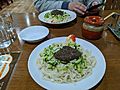
Morioka is famous for its unique local foods, especially its noodles!
- Noodles: You can try jajamen, reimen, and wanko soba. Each one offers a different and delicious taste.
- Brewing: Making drinks like sake is also a big industry in the city.
- Nambu senbei: These are a type of crispy rice cracker, a popular local snack.
-
Morioka jajamen
-

Morioka reimen


Media and News
Morioka has several local TV stations and newspapers:
- Iwate Asahi Television
- Iwate Broadcasting Company
- Iwate Menkoi Television
- Iwate Nippo (newspaper)
- Television Iwate
International Connections
Morioka has a special friendship with a city in Canada.
 Victoria, British Columbia, Canada (They have been sister cities since 1985.)
Famous People from Morioka
Many notable people have come from Morioka:
- Hara Takashi: A former Prime Minister of Japan.
- Takuboku Ishikawa: A well-known poet.
- Takuya Kawamura: A professional basketball player.
- Yusei Kikuchi: A professional baseball player.
- Yōko Mihara: An actress.
- Milano Collection A.T.: A professional wrestler.
- Taka Michinoku: A professional wrestler.
- The Great Sasuke: A professional wrestler.
- Inazō Nitobe: An author, educator, diplomat, and politician.
- Mitsuo Ogasawara: A footballer.
- Takatō Ōshima: An engineer who made Japan's first Western-style cannon.
- Mikoi Sasaki: An actress.
- Mitsumasa Yonai: A former Prime Minister of Japan.
- Nishikigi Tetsuya: A sumo wrestler.
- Yota Sato (boxer): A professional boxer.
See also
 In Spanish: Morioka para niños
