Monroe, Maine facts for kids
Quick facts for kids
Monroe, Maine
|
|
|---|---|

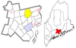
Location of Monroe (in yellow) in Waldo County and the state of Maine
|
|
| Country | United States |
| State | Maine |
| County | Waldo |
| Area | |
| • Total | 39.03 sq mi (101.09 km2) |
| • Land | 38.92 sq mi (100.80 km2) |
| • Water | 0.11 sq mi (0.28 km2) |
| Elevation | 371 ft (113 m) |
| Population
(2020)
|
|
| • Total | 931 |
| • Density | 24/sq mi (9.2/km2) |
| Time zone | UTC-5 (Eastern (EST)) |
| • Summer (DST) | UTC-4 (EDT) |
| ZIP code |
04951
|
| Area code(s) | 207 |
| FIPS code | 23-46475 |
| GNIS feature ID | 0582602 |
Monroe is a small town located in Waldo County, Maine, in the United States. It was named after President James Monroe. In 2020, about 931 people lived there.
Contents
Exploring Monroe's Geography
Monroe covers a total area of about 39.03 square miles (101.09 square kilometers). Most of this area is land, with only a small part being water.
Water Bodies in Monroe
Monroe has several ponds. The main ones are:
- Chase Bog Pond (67 acres)
- Basin Pond (28 acres)
- Lily Pond (27 acres)
- Thistle Pond (16 acres)
- Northern Pond (15 acres)
Monroe's Location and Neighbors
Monroe is found where two roads meet: Route 139 and Route 141. It shares its borders with several other towns:
- To the north: Newburgh
- To the east: Winterport and Frankfort
- To the south: Swanville
- To the southwest: Brooks
- To the west: Jackson
- To the northwest: Dixmont
Monroe's Population Over Time
The number of people living in Monroe has changed quite a bit over the years. Here's a look at how the population has grown and shrunk since 1820:
| Historical population | |||
|---|---|---|---|
| Census | Pop. | %± | |
| 1820 | 732 | — | |
| 1830 | 1,080 | 47.5% | |
| 1840 | 1,602 | 48.3% | |
| 1850 | 1,606 | 0.2% | |
| 1860 | 1,703 | 6.0% | |
| 1870 | 1,375 | −19.3% | |
| 1880 | 1,366 | −0.7% | |
| 1890 | 1,079 | −21.0% | |
| 1900 | 958 | −11.2% | |
| 1910 | 872 | −9.0% | |
| 1920 | 734 | −15.8% | |
| 1930 | 671 | −8.6% | |
| 1940 | 665 | −0.9% | |
| 1950 | 593 | −10.8% | |
| 1960 | 497 | −16.2% | |
| 1970 | 478 | −3.8% | |
| 1980 | 657 | 37.4% | |
| 1990 | 802 | 22.1% | |
| 2000 | 882 | 10.0% | |
| 2010 | 890 | 0.9% | |
| 2020 | 931 | 4.6% | |
| U.S. Decennial Census | |||
Monroe's Population in 2010
According to the census from 2010, there were 890 people living in Monroe. These people made up 402 households and 247 families. The town had about 22.9 people per square mile.
Most of the people living in Monroe were White (97.6%). A small number were African American (0.2%), Asian (0.2%), or from two or more racial backgrounds (1.9%). About 1.2% of the population identified as Hispanic or Latino.
Households and Families
Out of the 402 households:
- 22.6% had children under 18 living with them.
- 49.0% were married couples living together.
- 9.2% had a female head of the household without a husband.
- 3.2% had a male head of the household without a wife.
- 38.6% were not families.
About 30.3% of all households were made up of just one person. Also, 11% of households had someone living alone who was 65 years old or older. On average, there were 2.21 people per household and 2.77 people per family.
Age in Monroe
The average age of people in Monroe in 2010 was 47.5 years.
- 17.8% of residents were under 18 years old.
- 4.9% were between 18 and 24 years old.
- 23% were between 25 and 44 years old.
- 38.3% were between 45 and 64 years old.
- 16.1% were 65 years old or older.
The town had a nearly equal number of males and females, with 49.9% male and 50.1% female.
See also
 In Spanish: Monroe (Maine) para niños
 | Jackie Robinson |
 | Jack Johnson |
 | Althea Gibson |
 | Arthur Ashe |
 | Muhammad Ali |

